

Photo Credits (4)
Difficulty
Moderate
Trail Length
2.4 miles
Trail Type
Out And Back
Elevation Gain
350 ft
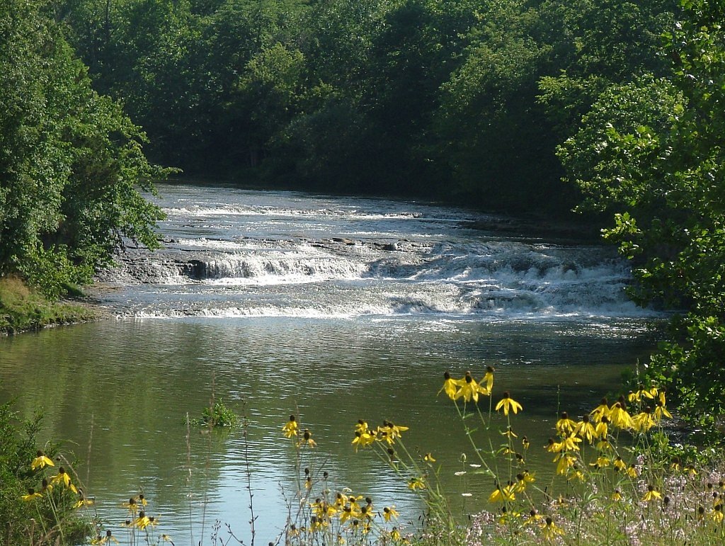
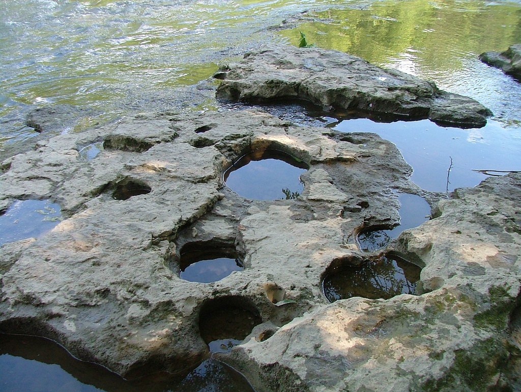
About Greenville Falls
Greenville Falls tumbles through a pocket of Miami County limestone, anchored within the Stillwater - Greenville Falls State Scenic River unit and managed by the SDNR. The falls sit inside a roughly 92-acre preserve that highlights sheer limestone cliffs, a cascading stream, and the evocative remnants of historic mill works — a compact, scenic spot that rewards both photographers and casual explorers. The site carries an SCA designation under SDNR stewardship, meaning the area is managed to protect its natural and cultural features while remaining welcoming to visitors. The property is best experienced on foot: a well-marked route weaves close to the gorge and offers repeated vantage points of the cascade and cliff faces. Expect a mix of gravel paths and raised boardwalks that make the falls accessible while protecting fragile terrain. This is a great outing for anyone looking for a shorter but engaging nature stop that combines geology, history, and water-filled beauty.
The Setting
Greenville Falls sits at 919 feet within Stillwater - Greenville Falls SR, fed by the Greenville Creek, in the foothills of Ohio.
Trail & Hike Details
The Approach
The moderate 2.4-mile out-and-back trail gains 350 feet of elevation on the way to the falls.
Trail Description
Trail type: out-and-back; total length: 2.4 miles; elevation gain: approximately 350 feet. Difficulty: moderate. Surface: primarily gravel walking paths with sections of boardwalk at sensitive viewpoints and wet areas. Grade: moderate overall, with rolling ups and downs as the trail follows the river corridor. The route is well defined but can be uneven in places; sturdy footwear is recommended for navigating roots, rocks, and boardwalk transitions.
What to Expect
Dogs are welcome.
Accessibility
The trail is not wheelchair accessible. Uneven terrain and elevation changes require steady footing.
Frequently Asked Questions
🐶 Are Dogs Allowed at Greenville Falls?
✅ Dogs are allowed
Are There Any Fees or Permits Required?
🆖 No fees required
🏊 Is There Swimming at Greenville Falls?
❌ Swimming is not allowed
When to Visit
Spring and early summer are ideal for visiting Greenville Falls, as the waterfall flow is typically stronger during these seasons. Fall offers beautiful foliage, and winter may provide unique ice formations.
Seasonal Access
The best time to visit is Spring, Summer, Fall, and Winter.
Safety Information
Stay on designated trails to avoid damaging the natural environment and for personal safety. Be cautious near the waterfall and cliffs, as rocks may be slippery.
Current Water Conditions
122 ft³/s
Current discharge — how much water is flowing
About average for this time of year
Based on 93 years of record
1.95 ft
Water depth at gauge
7-Day Discharge Trend
What does this mean for your visit?
Flow is about average for this time of year.
About This Gauge
7-Day Flow Outlook
Based on the USGS gauge Greenville Creek near Bradford OH (5 km away).
Today
Moderate
139 cfs
4/10Tomorrow
Moderate
143 cfs
8/10Mon
Moderate
129 cfs
8/10Tue
Moderate
119 cfs
8/10Wed
Moderate
118 cfs
8/10Thu
Moderate
134 cfs
4/10Fri
Moderate
157 cfs
4/10Best window: Tomorrow — moderate flow, partly sunny (trip score 8/10).
Best time of year: this gauge typically runs highest from late February to early May, peaking in April.
How we calculate this
This is a transparent outlook, not a precise forecast. We take the waterfall's current flow strength (how it ranks against its historical normal for today, from the nearest USGS stream gauge), carry that ranking forward along the gauge's seasonal curve, and nudge it for forecast rain. Confidence is highest for the next day or two and falls further out. Always check official conditions and your own judgment before visiting — high flows can be dangerous.
Know when to go.
Get a free email alert when waterfalls near Covington hit peak flow. We only send when conditions are worth the trip — no weekly newsletters, no spam.
Weather Forecast
Location & Access
Getting There
Greenville Falls is located near Covington, Ohio, and can be accessed via State Route 48. The preserve is well-marked with signs directing visitors to the parking area.
Get Directions on Google MapsParking
A small parking lot is available at the entrance to the Greenville Falls State Scenic River Area. Parking is free.
Elevation
919 feet above sea level
Coordinates
40.107273° N, -84.374671° W
Land Management
Managed by SDNR
Visitor Tips & Gear
Wear comfortable walking shoes as the trail may have uneven surfaces in some areas. Bring a camera to capture the scenic views. Visit after a rainfall for a more dramatic waterfall flow.
As an Amazon Associate, we earn from qualifying purchases.
With 2.4 miles and 350 ft of elevation gain, sturdy boots and trekking poles will help on this moderate trail. Icy conditions are common in winter — traction cleats are a smart addition.

Columbia Watertight II Rain Jacket
Packs into its own pocket, seam-sealed, and keeps you dry from spray and surprise rain.

Polarized Sunglasses (Knockaround)
Cuts glare off the water so you actually see the falls — and your photos turn out better too.

Earth Pak Waterproof Dry Bag
Keeps your phone and gear dry when waterfall mist soaks everything else.

Waterproof Phone Pouch (AiRunTech)
Cheap insurance — take photos right next to the falls without killing your phone.

Timberland Euro Sprint Mid Waterproof
Trusted waterproof boot with premium leather and grippy rubber sole — reliable on rocky, wet trails.

TrailBuddy Trekking Poles
Lightweight aluminum, cork grips, and flip-locks that actually hold — a best-seller for good reason.
Where to Stay

Home2 Suites Troy, OH

Comfort Suites Troy-I75

Holiday Inn Express & Suites Troy by IHG

Quality Inn Greenville North
Browse vacation cabins and private rentals nearby
Unique outdoor stays — tents, yurts, and treehouses
Rent a campervan or RV for your waterfall road trip
Some links are affiliate links. We may earn a commission at no extra cost to you.
Additional Information
Nearby Attractions
Nearby attractions include the Stillwater River, other Miami County parks, and the town of Covington, which offers dining and shopping options.
Wildlife
The area is home to various bird species, small mammals, and aquatic life. Visitors may also see wildflowers and native plants along the trail.
Cities near Greenville Falls
Writing about Greenville Falls? Embed this waterfall on your site for free.