Greasy Falls
Virginia • Shenandoah National Park
By Armen Suny · Last verified May 2026
Photo Credits (1)
Difficulty
Moderate
Trail Length
2.0 miles
Trail Type
Out And Back
Elevation Gain
300 ft
About Greasy Falls
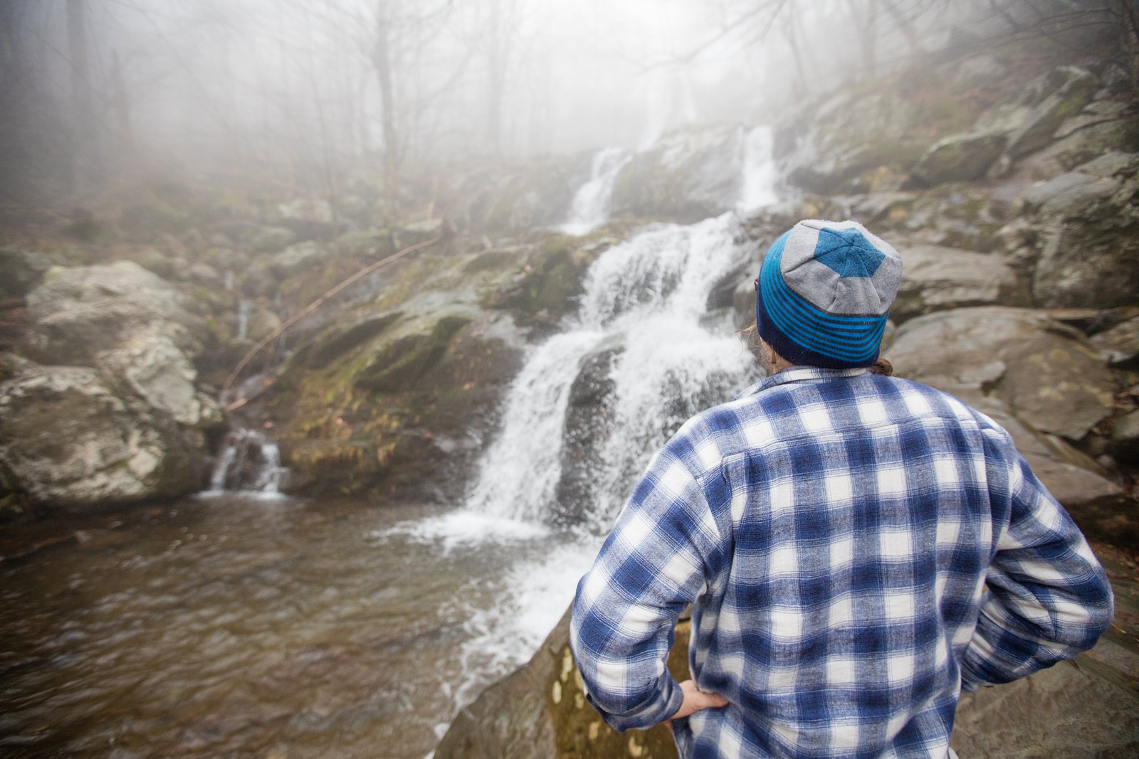
Greasy Falls is a tucked-away cascade inside Shenandoah National Park, managed by the National Park Service. Framed by lush, mature hardwood forest, the falls reward a short but satisfying hike with a peaceful plunge pool and plenty of quiet, nature-filled views. Hike the moderate 2.0-mile out-and-back route (about 300 feet of elevation gain) for a compact day outing that feels farther from the road than the mileage suggests. The setting is very much Shenandoah — shaded, wooded trails and seasonal stream flow — and Mathews Arm Campground is just over 3 km (about 3.06 km) away if you want to turn the trip into an overnight backcountry base. Because the trail can get rocky and slippery after rain, come prepared with sturdy footwear and expect a tranquil, less-crowded waterfall experience under NPS stewardship.
The Setting
Greasy Falls sits at 1,654 feet within Shenandoah National Park, fed by the S F Shenandoah River, in the hills of Virginia.
Trail & Hike Details
The Approach
The moderate 2.0-mile out-and-back trail gains 300 feet of elevation on the way to the falls.
Trail Description
Trail type: out-and-back; distance: 2.0 miles round trip; elevation gain: ~300 feet; difficulty: moderate. The path to Greasy Falls threads through dense, well-shaded hardwood forest with a mix of level walking and short, moderately steep pitches. Expect occasional rocky sections and muddy, slippery footing after wet weather, so hiking shoes with good traction are recommended. Located within Shenandoah National Park (managed by the NPS), the route is a straightforward, compact hike—suitable for most reasonably fit day hikers—and Mathews Arm Campground lies about 3.06 km away for nearby overnight camping.
What to Expect
Visitors can expect a tranquil waterfall surrounded by natural beauty. The falls may vary in flow depending on recent rainfall, with the best views typically occurring in spring or after heavy rain. The area is relatively secluded, offering a quiet experience.
Accessibility
The trail is not wheelchair accessible. Uneven terrain and elevation changes require steady footing.
Frequently Asked Questions
🐶 Are Dogs Allowed at Greasy Falls?
❌ Dogs are not allowed
Are There Any Fees or Permits Required?
🆖 No fees required
🏊 Is There Swimming at Greasy Falls?
❌ Swimming is not allowed
When to Visit
Spring and early summer are ideal for visiting Greasy Falls, as the water flow is usually strongest during these seasons.
Seasonal Access
The best time to visit is Spring, Summer, and Fall. Winter access may be limited. Check with Shenandoah National Park for current conditions.
Safety Information
The trail may be slippery after rain, and there are no guardrails near the falls. Visitors should stay on marked paths and avoid getting too close to the edge of the waterfall. Cell service may be unreliable, so inform someone of your plans before visiting.
Current Water Conditions
526 ft³/s
Current discharge — how much water is flowing
Lower than usual for this time of year
Based on 95 years of record
1.35 ft
Water depth at gauge
7-Day Discharge Trend
What does this mean for your visit?
Flow is lower than usual for this time of year.
About This Gauge
This gauge is on a nearby waterway and may not reflect exact conditions at the falls.
7-Day Flow Outlook
Based on the USGS gauge S F SHENANDOAH RIVER AT FRONT ROYAL, VA (16 km away).
Today
Roaring
526 cfs
9/10Tomorrow
Roaring
523 cfs
9/10Fri
Roaring
584 cfs
6/10Sat
Roaring
600 cfs
6/10Sun
Roaring
605 cfs
6/10Mon
Roaring
509 cfs
9/10Tue
Roaring
534 cfs
6/10Best window: Today — roaring flow, sunny (trip score 9/10).
Best time of year: this gauge typically runs highest from mid February to early May, peaking in March.
How we calculate this
This is a transparent outlook, not a precise forecast. We take the waterfall's current flow strength (how it ranks against its historical normal for today, from the nearest USGS stream gauge), carry that ranking forward along the gauge's seasonal curve, and nudge it for forecast rain. Confidence is highest for the next day or two and falls further out. Always check official conditions and your own judgment before visiting — high flows can be dangerous.
Know when to go.
Get a free email alert when waterfalls near Sperryville hit peak flow. We only send when conditions are worth the trip — no weekly newsletters, no spam.
Weather Forecast
Location & Access
Getting There
Greasy Falls is located in a remote area of Virginia. Access may require driving on unpaved roads, and signage to the falls may be limited. Visitors are advised to use GPS coordinates or detailed maps to locate the trailhead.
Get Directions on Google MapsParking
Parking availability is limited and may consist of a small gravel lot or roadside parking near the trailhead.
Elevation
1,654 feet above sea level
Coordinates
38.774006° N, -78.267502° W
Land Management
Managed by NPS
Visitor Tips & Gear
Bring sturdy hiking shoes, as the trail can be uneven or muddy. Carry water and snacks, as there are no facilities nearby. Cell service may be limited, so plan accordingly.
As an Amazon Associate, we earn from qualifying purchases.
With 2.0 miles and 300 ft of elevation gain, sturdy boots and trekking poles will help on this moderate trail. Sun exposure on the trail makes good sun protection a must in summer.
America the Beautiful Annual Pass
Covers entrance fees at 2,000+ federal recreation sites — required at most National Parks.

Polarized Sunglasses (Knockaround)
Cuts glare off the water so you actually see the falls — and your photos turn out better too.

Columbia Watertight II Rain Jacket
Packs into its own pocket, seam-sealed, and keeps you dry from spray and surprise rain.

Earth Pak Waterproof Dry Bag
Keeps your phone and gear dry when waterfall mist soaks everything else.

Waterproof Phone Pouch (AiRunTech)
Cheap insurance — take photos right next to the falls without killing your phone.

Timberland Euro Sprint Mid Waterproof
Trusted waterproof boot with premium leather and grippy rubber sole — reliable on rocky, wet trails.

TrailBuddy Trekking Poles
Lightweight aluminum, cork grips, and flip-locks that actually hold — a best-seller for good reason.
Where to Stay

Riverside Oasis with Stunning Views, Cozy Firepit!

Doubletree By Hilton Front Royal Blue Ridge Shadows

Barney's Retreat- Rustic cabin on the river!

All Seasons Cottage - Game Room - Firepit By Zen Living Short Term Rental
Browse vacation cabins and private rentals nearby
Unique outdoor stays — tents, yurts, and treehouses
Rent a campervan or RV for your waterfall road trip
Some links are affiliate links. We may earn a commission at no extra cost to you.
Nearby Campground
MATHEWS ARM CAMPGROUND
1.9 miles away · 166 sites
Overview Secluded in the thick trees and rolling hills of the Shenandoah National Park, Mathews Arm Campground is the ideal spot for a camping getaway.Recreation Shenandoah National Park has over 500 miles of trails, including 101 miles of the Appalachian Trail. Some trails lead to a waterfall or viewpoint while others wind deep into the forests and wilderness. Mathews Arm Campground is located near Overall Run Falls, which, at 93 feet, has the highest drop of all the falls in Shenandoah National
Book on Recreation.govNearby Hot Springs
Hot springs near Sperryville, Virginia

Looking for a soak after your hike? Explore more hot springs near Sperryville, Virginia on SoakingSprings.
Explore Virginia springsAdditional Information
Nearby Attractions
Other hiking trails and natural attractions in the area may include scenic overlooks and smaller waterfalls.
Wildlife
The area is home to a variety of wildlife, including birds, deer, and small mammals. Visitors should be cautious of ticks and other insects.
Cities near Greasy Falls
Nearby Waterfalls
Writing about Greasy Falls? Embed this waterfall on your site for free.