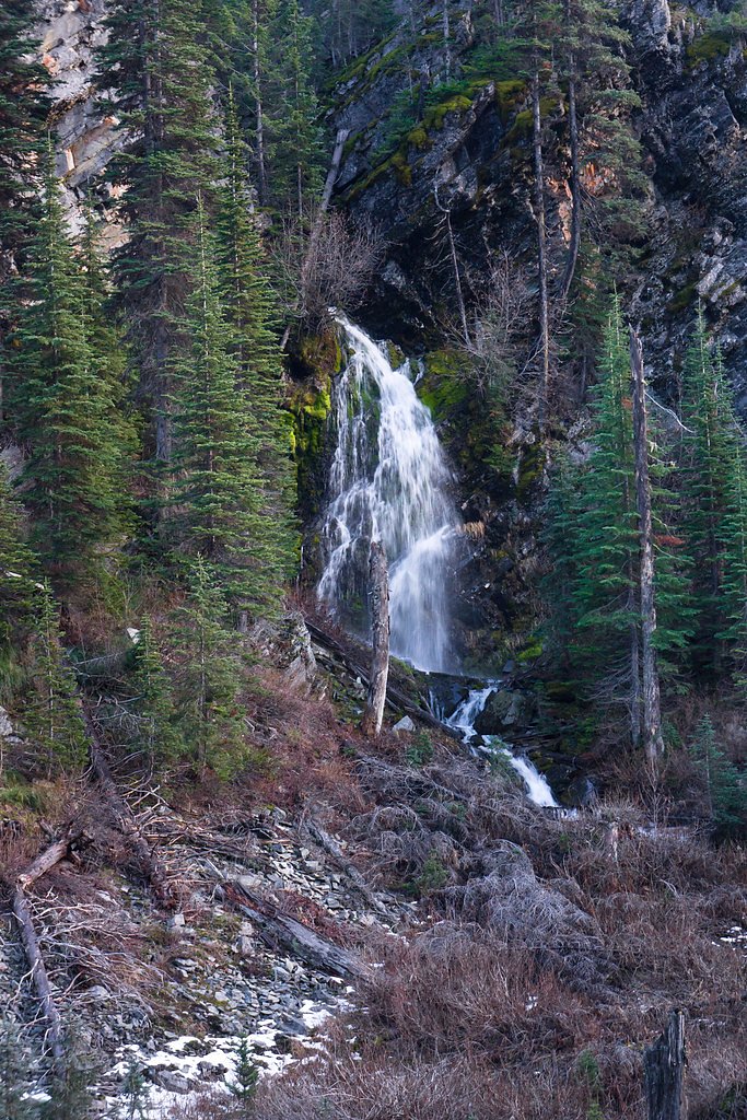
Graves Creek Falls
By Armen Suny · Last verified Mar 2026
Photo Credits (1)
Difficulty
Moderate
Trail Length
2.4 miles
Trail Type
Out And Back
Elevation Gain
350 ft
About Graves Creek Falls
Graves Creek Falls is a peaceful cascade tucked into Montana’s Lolo National Forest and managed by the U.S. Forest Service. The falls sit amid mature forest and make for a lovely destination for photographers and day hikers; the USFS approach follows WINNIEMUCK CREEK (Trail #506), which leads you into the creek corridor where the water tumbles over rock outcrops. The most commonly used route to the falls is an out-and-back trek of about 2.4 miles with roughly 350 feet of elevation gain, rated moderate. USFS trail data characterizes WINNIEMUCK CREEK Trail #506 as a native-material tread, Class 2, with typical grades of 12–20% (USFS GIS records also list the trail at 5.7 miles). If you’re planning an overnight or a longer stay, Cougar Peak Lookout campground is nearby (about 2.65 km), providing convenient camping within a short drive of the trailhead.
The Setting
Graves Creek Falls sits at 2,877 feet within Lolo National Forest, fed by the Prospect Creek, in the hills of Montana.
Trail & Hike Details
The Approach
The moderate hike follows Winniemuck Creek (#506), a 2.4-mile out-and-back trail over natural surface. Expect 350 feet of elevation gain with grades of 12-20%. The trail is moderately developed (Class 2).
USFS Trail
WINNIEMUCK CREEK #506
Trail Class
Moderately Developed
Surface
Avg Grade
USFS Segment
5.70 miTrail Description
Trail: WINNIEMUCK CREEK (USFS Trail #506). Surface: native material. Class: 2. Typical grade: 12–20%. Length: commonly hiked as a 2.4-mile out-and-back to Graves Creek Falls with approximately 350 ft elevation gain (USFS GIS records list the trail at 5.7 miles). Difficulty: moderate. Trail type: out-and-back. Expect mostly native tread with moderate pitch and short steeper sections—suitable for hikers comfortable on uneven forest trails.
What to Expect
Dogs are welcome.
Accessibility
The trail is not wheelchair accessible. Uneven terrain and elevation changes require steady footing.
Frequently Asked Questions
🐶 Are Dogs Allowed at Graves Creek Falls?
✅ Dogs are allowed
Are There Any Fees or Permits Required?
🆖 No fees required
🏊 Is There Swimming at Graves Creek Falls?
❌ Swimming is not allowed
When to Visit
Spring and early summer are the best times to visit, as the water flow is strongest during these seasons.
Seasonal Access
The best time to visit is Spring, Summer, and Fall. Winter access may be limited. Check with Lolo National Forest for seasonal road closures.
Safety Information
Be cautious near the water as rocks can be slippery. Check weather and road conditions before visiting, especially in winter. Carry bear spray if hiking in the area.
Current Water Conditions
118 ft³/s
Current discharge — how much water is flowing
Lower than usual for this time of year
Based on 69 years of record
1.30 ft
Water depth at gauge
7-Day Discharge Trend
What does this mean for your visit?
Flow is lower than usual for this time of year.
About This Gauge
This gauge is on a nearby waterway and may not reflect exact conditions at the falls.
7-Day Flow Outlook
Based on the USGS gauge Prospect Creek at Thompson Falls MT (15 km away).
Today
Moderate
127 cfs
5/10Tomorrow
Moderate
125 cfs
5/10Mon
Moderate
119 cfs
5/10Tue
Moderate
123 cfs
4/10Wed
Moderate
113 cfs
5/10Thu
Low
98 cfs
6/10Fri
Moderate
98 cfs
5/10Best window: Thu — low flow, mostly sunny (trip score 6/10).
Best time of year: this gauge typically runs highest from late March to late June, peaking in May.
How we calculate this
This is a transparent outlook, not a precise forecast. We take the waterfall's current flow strength (how it ranks against its historical normal for today, from the nearest USGS stream gauge), carry that ranking forward along the gauge's seasonal curve, and nudge it for forecast rain. Confidence is highest for the next day or two and falls further out. Always check official conditions and your own judgment before visiting — high flows can be dangerous.
Know when to go.
Get a free email alert when waterfalls near Thompson Falls hit peak flow. We only send when conditions are worth the trip — no weekly newsletters, no spam.
Weather Forecast
Location & Access
Getting There
Graves Creek Falls is located off Graves Creek Road, approximately 15 miles northwest of Thompson Falls, Montana. The falls are accessible via a short drive on a gravel road, but conditions may vary depending on the season.
Get Directions on Google MapsParking
There is a small parking area near the falls, but space may be limited during peak seasons.
Elevation
2,877 feet above sea level
Coordinates
47.720873° N, -115.378096° W
Land Management
Managed by USFS
Visitor Tips & Gear
Visit early in the day to avoid crowds and ensure parking availability. Wear sturdy shoes as the area near the falls may be slippery. Check road conditions before visiting, especially in winter or after heavy rains.
As an Amazon Associate, we earn from qualifying purchases.
With 2.4 miles and 350 ft of elevation gain, sturdy boots and trekking poles will help on this moderate trail. Sun exposure on the trail makes good sun protection a must in summer.

Polarized Sunglasses (Knockaround)
Cuts glare off the water so you actually see the falls — and your photos turn out better too.

Columbia Watertight II Rain Jacket
Packs into its own pocket, seam-sealed, and keeps you dry from spray and surprise rain.

Earth Pak Waterproof Dry Bag
Keeps your phone and gear dry when waterfall mist soaks everything else.

Waterproof Phone Pouch (AiRunTech)
Cheap insurance — take photos right next to the falls without killing your phone.

Timberland Euro Sprint Mid Waterproof
Trusted waterproof boot with premium leather and grippy rubber sole — reliable on rocky, wet trails.

TrailBuddy Trekking Poles
Lightweight aluminum, cork grips, and flip-locks that actually hold — a best-seller for good reason.
Where to Stay

Rimrock Lodge LLC

Rocky Point Ranch, Montana

Riverfront Motel & Cabins

Stardust Motel Wallace
Browse vacation cabins and private rentals nearby
Unique outdoor stays — tents, yurts, and treehouses
Rent a campervan or RV for your waterfall road trip
Some links are affiliate links. We may earn a commission at no extra cost to you.
Nearby Campground
COUGAR PEAK LOOKOUT
1.6 miles away · 1 sites
Overview The Cougar Peak Lookout offers guests an opportunity to experience an old-time Forest Service lookout. The tower commands an impressive view of the river valley, the surrounding Cabinet Mountains and the opposing Coeur d'Alene Mountains. The structure is small and is not elevated like many other lookouts. The lookout can be accessed by vehicle, although late spring snow drifts may compromise parts of the road, requiring visitors to hike a short distance. Guests are responsible for their
Book on Recreation.govNearby Hot Springs
Hot springs near Thompson Falls, Montana
Camas Hot Springs
Camas Hot Springs flows at 113°F on the Flathead Reservation in western Montana, managed as tribal land with restricted or unkn...
Wild Horse Hot Springs
Wild Horse Hot Springs sits on the Flathead Reservation in Sanders County, Montana, near Plains, at 2,756 feet, one of the lowe...
Quinns Hot Springs
Quinns Hot Springs flows at 109 degrees Fahrenheit in the Clark Fork River valley of Sanders County, Montana, at a low elevatio...
Green Springs
Green Springs flows at 79°F on the Flathead Reservation in Sanders County, Montana, at 2,813 feet — one of the lower-elevation ...
Looking for a soak after your hike? Explore more hot springs near Thompson Falls, Montana on SoakingSprings.
Explore Montana springsAdditional Information
Nearby Attractions
Thompson Falls State Park, Kootenai Falls, Ross Creek Cedars Scenic Area
Wildlife
The area is home to various wildlife, including deer, birds, and occasionally bears. Visitors should exercise caution and follow wildlife safety guidelines.
Cities near Graves Creek Falls
Writing about Graves Creek Falls? Embed this waterfall on your site for free.