


Photo Credits (5)
Difficulty
Moderate
Trail Length
2.4 miles
Trail Type
Out And Back
Elevation Gain
350 ft
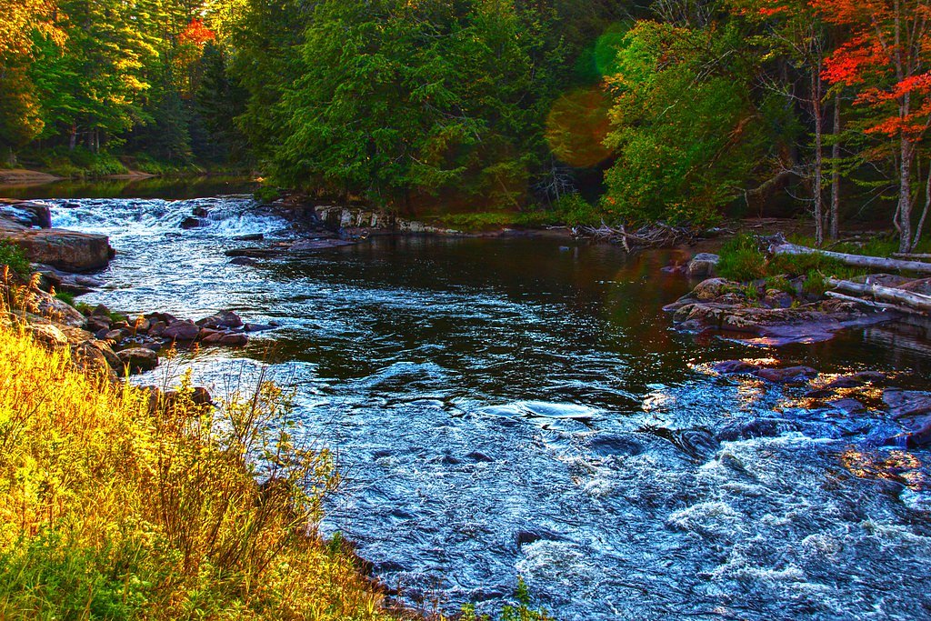
About Flat Rock Falls
Flat Rock Falls is a tucked-away cascade set within New York’s Grass River Wild Forest, offering a peaceful stop for hikers who appreciate layered ledges and the soft roar of falling water. The site is on land owned and managed by SDC and carries the area’s SCA designation, which helps protect the natural character of the falls and surrounding forest. The falls’ broad, flat rock formations create several low cascades and shallow pools that invite photography and quiet observation rather than swimming or heavy use. Access to Flat Rock Falls feels suitably wild without being remote: the approach threads through mixed woods and opens onto a scenic rock apron above the water. Seasonal color and spring run-off are especially striking; because the site is managed by SDC within the Grass River Wild Forest, visitors should follow leave-no-trace practices and any posted rules that protect fragile habitats and the stream corridor.
The Setting
Flat Rock Falls sits at 1,040 feet within Grass River Wild Forest, fed by the Oswegatchie River, in the foothills of New York.
Trail & Hike Details
The Approach
The moderate 2.4-mile out-and-back trail gains 350 feet of elevation on the way to the falls.
Trail Description
The trail is a 2.4-mile out-and-back route with roughly 350 feet of elevation gain and is rated moderate. The hike follows forested terrain with a steady but manageable grade—expect a moderately strenuous walk rather than technical scrambling. Suitable for most hikers comfortable with a moderate uphill effort, the route typically requires good footing in places; there are no formal USFS trail number or surface/class details provided for this route, so pack appropriate footwear and plan for changing trail conditions.
What to Expect
Dogs are welcome.
Accessibility
The trail is not wheelchair accessible. Uneven terrain and elevation changes require steady footing.
Frequently Asked Questions
🐶 Are Dogs Allowed at Flat Rock Falls?
✅ Dogs are allowed
Are There Any Fees or Permits Required?
🆖 No fees required
🏊 Is There Swimming at Flat Rock Falls?
❌ Swimming is not allowed
When to Visit
The best time to visit Flat Rock Falls is during the spring and early summer when water flow is at its peak. Fall is also a great time to visit for the vibrant foliage.
Seasonal Access
The best time to visit is Spring, Summer, and Fall. Winter access may be limited.
Safety Information
Exercise caution near the waterfall as rocks may be slippery. Be aware of changing weather conditions and avoid the area during heavy rain or storms.
Current Water Conditions
425 ft³/s
Current discharge — how much water is flowing
About average for this time of year
Based on 82 years of record
2.96 ft
Water depth at gauge
7-Day Discharge Trend
What does this mean for your visit?
Flow is about average for this time of year.
About This Gauge
This gauge is on a nearby waterway and may not reflect exact conditions at the falls.
7-Day Flow Outlook
Based on the USGS gauge OSWEGATCHIE RIVER NEAR OSWEGATCHIE NY (12 km away).
Today
Low
511 cfs
3/10Tomorrow
Moderate
549 cfs
4/10Thu
Moderate
524 cfs
4/10Fri
Moderate
490 cfs
4/10Sat
Moderate
389 cfs
4/10Sun
Moderate
479 cfs
4/10Mon
Moderate
464 cfs
4/10Best window: Tomorrow — moderate flow, chance showers and thunderstorms (trip score 4/10).
Best time of year: this gauge typically runs highest from early March to mid May, peaking in April.
How we calculate this
This is a transparent outlook, not a precise forecast. We take the waterfall's current flow strength (how it ranks against its historical normal for today, from the nearest USGS stream gauge), carry that ranking forward along the gauge's seasonal curve, and nudge it for forecast rain. Confidence is highest for the next day or two and falls further out. Always check official conditions and your own judgment before visiting — high flows can be dangerous.
Know when to go.
Get a free email alert when waterfalls near Star Lake hit peak flow. We only send when conditions are worth the trip — no weekly newsletters, no spam.
Weather Forecast
Location & Access
Getting There
Flat Rock Falls is located near the town of Willsboro in the Adirondack region of New York. Access is typically via local roads, and visitors should use GPS or local maps to navigate to the trailhead.
Get Directions on Google MapsParking
Parking is available near the trailhead, but spaces may be limited during peak seasons. Visitors are advised to arrive early to secure a spot.
Elevation
1,040 feet above sea level
Coordinates
44.318395° N, -75.007697° W
Land Management
Managed by SDC
Visitor Tips & Gear
Wear sturdy footwear as the trail may be muddy or slippery, especially after rain. Bring insect repellent during the summer months. Arrive early to avoid crowds and secure parking.
As an Amazon Associate, we earn from qualifying purchases.
With 2.4 miles and 350 ft of elevation gain, sturdy boots and trekking poles will help on this moderate trail. Sun exposure on the trail makes good sun protection a must in summer.

Polarized Sunglasses (Knockaround)
Cuts glare off the water so you actually see the falls — and your photos turn out better too.

Columbia Watertight II Rain Jacket
Packs into its own pocket, seam-sealed, and keeps you dry from spray and surprise rain.

Earth Pak Waterproof Dry Bag
Keeps your phone and gear dry when waterfall mist soaks everything else.

Waterproof Phone Pouch (AiRunTech)
Cheap insurance — take photos right next to the falls without killing your phone.

Timberland Euro Sprint Mid Waterproof
Trusted waterproof boot with premium leather and grippy rubber sole — reliable on rocky, wet trails.

TrailBuddy Trekking Poles
Lightweight aluminum, cork grips, and flip-locks that actually hold — a best-seller for good reason.
Where to Stay

Camp Lake Bear

Fairfield Inn & Suites by Marriott Canton

Windjammer Lodge

Best Western University Inn
Browse vacation cabins and private rentals nearby
Unique outdoor stays — tents, yurts, and treehouses
Rent a campervan or RV for your waterfall road trip
Some links are affiliate links. We may earn a commission at no extra cost to you.
Additional Information
Nearby Attractions
Nearby attractions include Willsboro Point and other hiking trails in the Adirondack region.
Wildlife
The area is home to a variety of wildlife, including birds, deer, and small mammals. Visitors should be cautious of ticks and other insects.
Cities near Flat Rock Falls
Nearby Waterfalls


Writing about Flat Rock Falls? Embed this waterfall on your site for free.