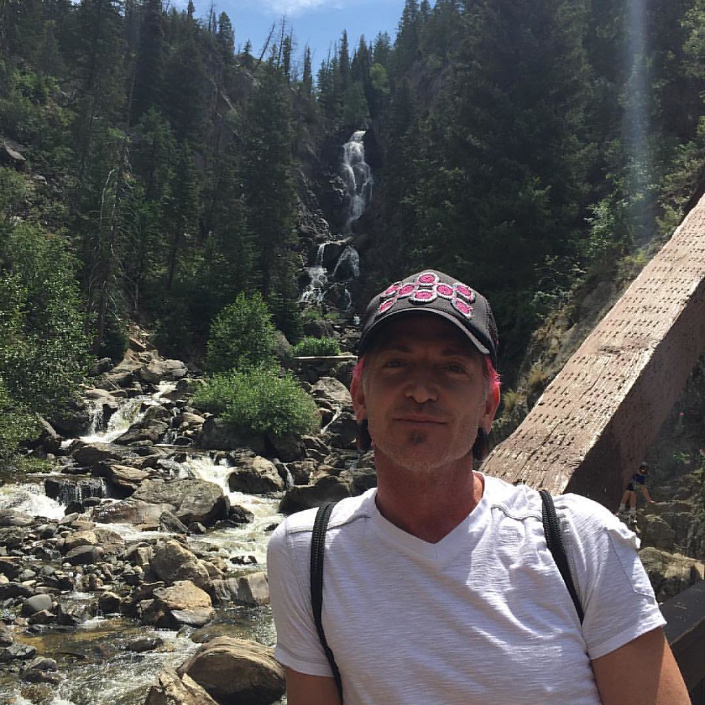
Fish Creek Falls
Colorado • 280 ft
By Armen Suny · Last verified Mar 2026
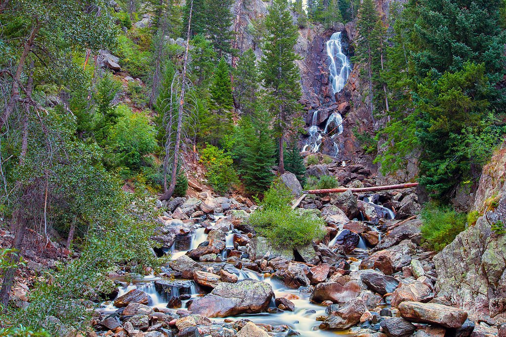
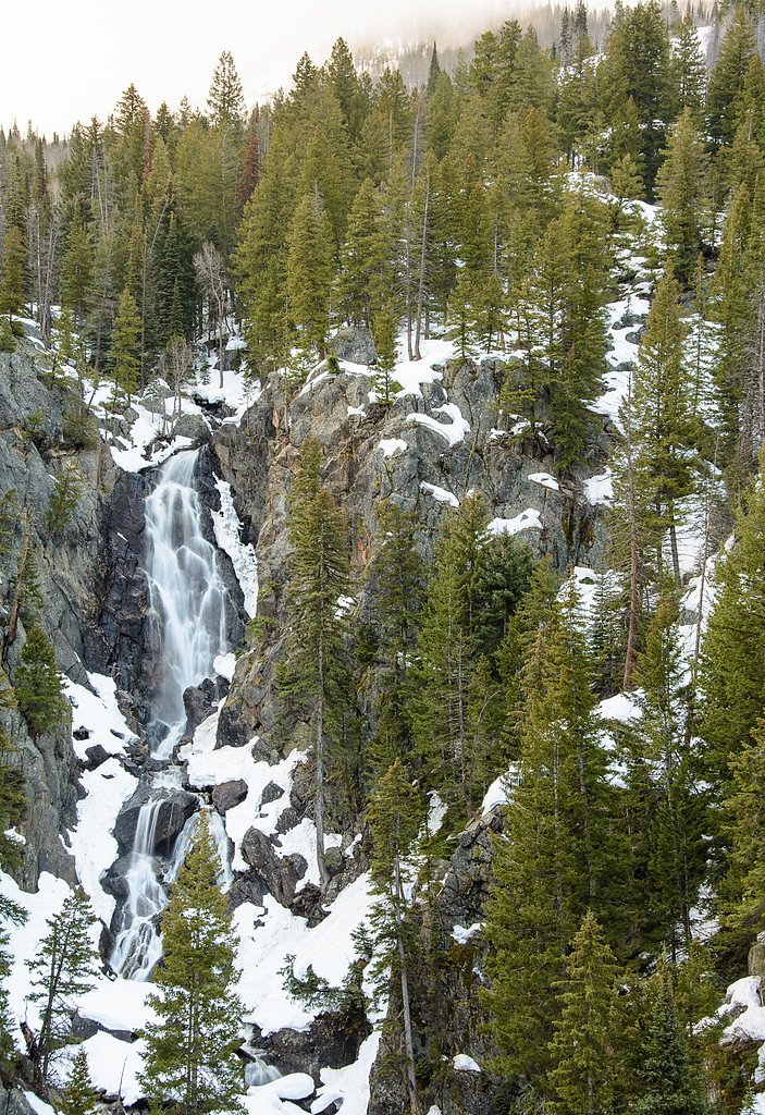
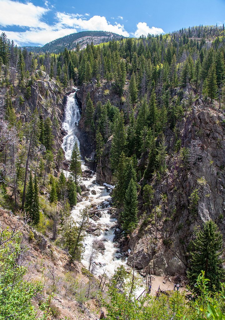
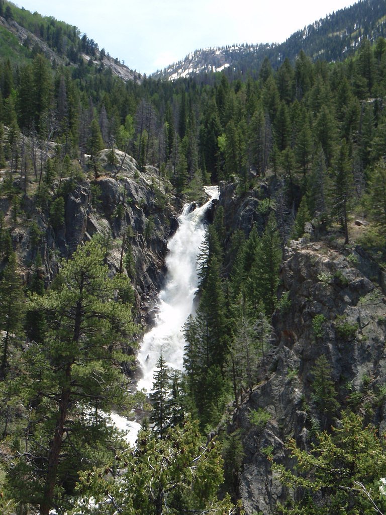
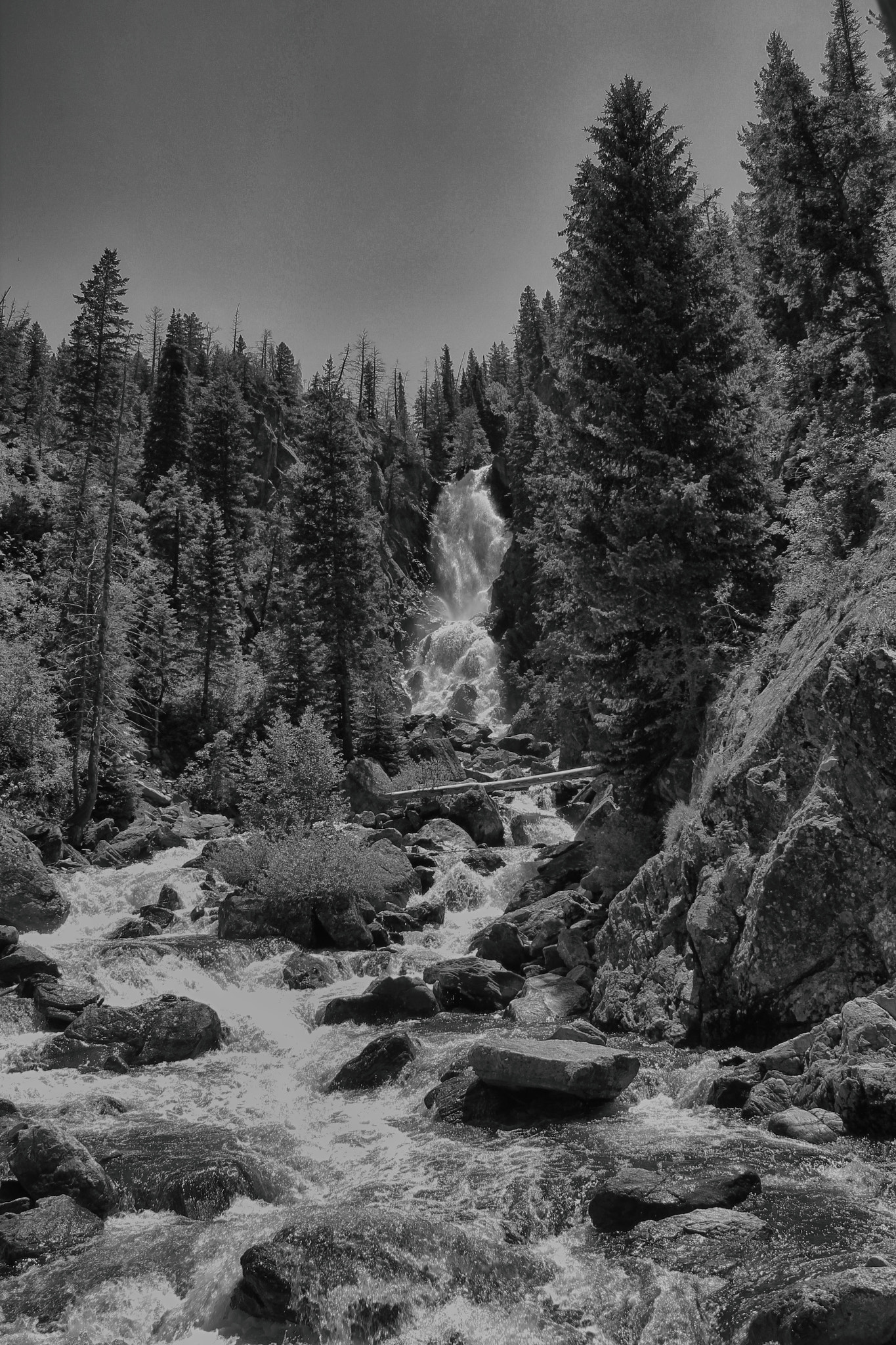
Photo Credits (5)
Difficulty
Moderate
Trail Length
0.5 miles
Trail Type
Out And Back
Elevation Gain
150 ft
About Fish Creek Falls
Fish Creek Falls is a dramatic roughly 283-foot (86 m) cascade tucked about 5 miles east of Steamboat Springs in Routt National Forest, managed by the U.S. Forest Service. Fish Creek flows down from several small lakes in the Rabbit Ears Range, carving a scenic gorge that draws photographers and families alike. In spring the falls are at their most thunderous with snowmelt, and in summer the access road often becomes congested in mid-afternoon as visitors arrive to catch the views. From the parking area at the end of Fish Creek Fall Road you’ll find options for all abilities: a short, paved viewpoint path for quick access to the lower falls, and longer routes that climb toward the upper cascades. The U.S. Forest Service maintains the nearby Creekside Trail (Trail #1001.1) for hikers looking to extend their visit, and the closest developed camping is managed by the Hahns Peak/Bears Ears Ranger District about 5.39 km away—handy for overnight stays and multi-day trips.
The Setting
Fish Creek Falls sits at 7,536 feet within Routt National Forest, in the high mountains of Colorado. At 280 feet, it is among the taller waterfalls in Colorado.
Height: 280 feet
Trail & Hike Details
The Approach
The moderate hike follows Creekside (#1001.1), a 0.5-mile out-and-back trail over natural surface. Expect 150 feet of elevation gain with grades of 12-20%. The trail is developed (Class 3).
USFS Trail
CREEKSIDE #1001.1
Trail Class
Developed
Surface
Avg Grade
USFS Segment
1.16 miTrail Description
From the lot there are two common choices. The short paved path to the lower falls is an easy, well-defined viewpoint route—about 0.5 miles round-trip with roughly 150 feet of elevation gain—an out-and-back that’s suitable for most visitors wanting a quick, scenic stop. For a longer, more rugged option use the U.S. Forest Service Creekside Trail (Trail #1001.1). According to USFS GIS data the Creekside route measures about 1.16 miles, is classified Class 3, and has a natural (NAT) tread surface. Expect sustained grades in the 12–20% range and some rocky, steeper sections as you gain elevation toward the upper falls; the trail is maintained by the USFS within Routt National Forest and is the route to choose when you want a more adventurous hike.
What to Expect
The falls plunge 280 feet. Dogs are welcome.
Accessibility
The trail is not wheelchair accessible. Uneven terrain and elevation changes require steady footing.
Frequently Asked Questions
🐶 Are Dogs Allowed at Fish Creek Falls?
✅ Dogs are allowed
Are There Any Fees or Permits Required?
🤑 Fee: $5.00
🏊 Is There Swimming at Fish Creek Falls?
❌ Swimming is not allowed
When to Visit
Spring and early summer are the best times to visit Fish Creek Falls, as the snowmelt creates a dramatic and powerful waterfall. Fall offers beautiful foliage, while winter provides a unique opportunity to see the frozen falls.
Seasonal Access
The best time to visit is Spring, Summer, Fall, and Winter. Check with Routt National Forest for seasonal road closures.
Safety Information
The trail to the upper falls can be steep and rocky, so proper footwear is essential. Be cautious of slippery rocks near the waterfall. In winter, trails may be icy and require traction devices.
Current Water Conditions
54 ft³/s
Current discharge — how much water is flowing
Lower than usual for this time of year
Based on 50 years of record
1.13 ft
Water depth at gauge
7-Day Discharge Trend
What does this mean for your visit?
Flow is lower than usual for this time of year.
About This Gauge
7-Day Flow Outlook
Based on the USGS gauge FISH CR AT UPPER STA NR STEAMBOAT SPRINGS, CO (2 km away).
Today
Roaring
62 cfs
6/10Tomorrow
Strong
55 cfs
10/10Sun
Strong
45 cfs
10/10Mon
Strong
42 cfs
10/10Tue
Strong
39 cfs
10/10Wed
Strong
34 cfs
10/10Thu
Strong
32 cfs
10/10Best window: Tomorrow — strong flow, sunny (trip score 10/10).
Best time of year: this gauge typically runs highest from mid April to mid July, peaking in June.
How we calculate this
This is a transparent outlook, not a precise forecast. We take the waterfall's current flow strength (how it ranks against its historical normal for today, from the nearest USGS stream gauge), carry that ranking forward along the gauge's seasonal curve, and nudge it for forecast rain. Confidence is highest for the next day or two and falls further out. Always check official conditions and your own judgment before visiting — high flows can be dangerous.
Know when to go.
Get a free email alert when waterfalls near Steamboat Springs hit peak flow. We only send when conditions are worth the trip — no weekly newsletters, no spam.
Weather Forecast
Location & Access
Getting There
Fish Creek Falls is located approximately 4 miles from downtown Steamboat Springs, Colorado. From downtown, take Fish Creek Falls Road to the parking area at the trailhead.
Get Directions on Google MapsParking
There is a designated parking area at the trailhead. A small fee is required for parking, typically $5 per vehicle. Parking can fill up quickly during peak seasons, so arriving early is recommended.
Elevation
7,536 feet above sea level
Coordinates
40.481351° N, -106.771246° W
Land Management
Managed by USFS
Visitor Tips & Gear
Arrive early to secure parking, especially during weekends and holidays. Wear sturdy hiking shoes if planning to hike to the upper falls. Bring plenty of water and sunscreen, as parts of the trail are exposed to the sun.
This trail sits at 7,536 ft above sea level
Elevated TrailUV radiation is roughly 30% stronger at this elevation than at sea level, and the dry air accelerates dehydration. Extra sun protection and fluids go a long way.
As an Amazon Associate, we earn from qualifying purchases.

Coppertone Sport SPF 50 Sunscreen
UV intensity jumps ~4% per 1,000 ft — at this elevation you can burn in half the time.

Sun Bum SPF 30 Lip Balm (3-Pack)
Lips have almost no natural UV protection and burn fast in thin, dry mountain air.

Liquid I.V. Electrolyte Packets
You lose moisture ~2x faster at elevation — electrolytes help you absorb water efficiently.

ROCKNIGHT Polarized UV400 Sunglasses
High-altitude glare off rock and water is intense — UV400 lenses block 99%+ of UVA/UVB.
As an Amazon Associate, we earn from qualifying purchases.
With 0.5 miles and 150 ft of elevation gain, sturdy boots and trekking poles will help on this moderate trail. Icy conditions are common in winter — traction cleats are a smart addition.

Columbia Watertight II Rain Jacket
Packs into its own pocket, seam-sealed, and keeps you dry from spray and surprise rain.

Polarized Sunglasses (Knockaround)
Cuts glare off the water so you actually see the falls — and your photos turn out better too.

Earth Pak Waterproof Dry Bag
Keeps your phone and gear dry when waterfall mist soaks everything else.

Waterproof Phone Pouch (AiRunTech)
Cheap insurance — take photos right next to the falls without killing your phone.

Timberland Euro Sprint Mid Waterproof
Trusted waterproof boot with premium leather and grippy rubber sole — reliable on rocky, wet trails.

TrailBuddy Trekking Poles
Lightweight aluminum, cork grips, and flip-locks that actually hold — a best-seller for good reason.
Where to Stay

Holiday Inn Express & Suites Steamboat Springs by IHG

Walk to Slopes, Heated Pool & Hot Tub, Ground Level Unit

Homewood Suites By Hilton Steamboat Springs

Residence Inn by Marriott Steamboat Springs
Browse vacation cabins and private rentals nearby
Unique outdoor stays — tents, yurts, and treehouses
Rent a campervan or RV for your waterfall road trip
Some links are affiliate links. We may earn a commission at no extra cost to you.
Nearby Campground
Hahns Peak/Bears Ears Ranger District
3.3 miles away · 0 sites
The Hahns Peak/Bears Ears Ranger District includes about 500,000 acres of the Routt National Forest, and terrain ranges from sagebrush flats to forested mountains. There are a wide variety of year-round recreation opportunities available to visitors. The Ranger District office is in Steamboat Springs, Colo. Scroll down for area-specific activities, locations and maps...Select California Park/Black Mountain, Mount Zirkel/Park Range, North Routt, or Steamboat under 'Areas & Activities' in the right
Book on Recreation.govNearby Hot Springs
Hot springs near Steamboat Springs, Colorado

Steamboat Springs
Steamboat Springs reaches 102 degrees Fahrenheit in the heart of a famous Colorado ski town, fed by the same geothermal resourc...
Routt Hot Springs
Routt Hot Springs emerges at a scalding 147°F in Routt County near Steamboat Springs at 7,499 feet elevation, making it one of ...
Strawberry Park Hot Springs
Strawberry Park Hot Springs operates as a developed commercial facility near Steamboat Springs at 7,440 feet elevation, chargin...
Radium Hot Springs (Colorado)
Radium Hot Springs flows at approximately 104°F on Colorado State Wildlife property, situated roughly halfway between Kremmling...

Radium Hot Springs
Radium Hot Springs emerges on Bureau of Land Management property in the Upper Colorado River Special Recreation Management Area...

Hot Sulphur Springs
Hot Sulphur Springs flows at 111°F along Parshall Divide Road in Grand County, emerging just 58 feet from the pavement in the s...
Looking for a soak after your hike? Explore more hot springs near Steamboat Springs, Colorado on SoakingSprings.
Explore Colorado springsAdditional Information
Nearby Attractions
Steamboat Springs, Strawberry Park Hot Springs, Yampa River Botanic Park
Wildlife
The area is home to various wildlife, including deer, birds, and occasionally bears. Visitors should exercise caution and follow Leave No Trace principles.
Cities near Fish Creek Falls
Writing about Fish Creek Falls? Embed this waterfall on your site for free.