Falls of Dismal
By Armen Suny · Last verified Mar 2026
Photo Credits (1)
Difficulty
Moderate
Trail Length
2.4 miles
Trail Type
Out And Back
Elevation Gain
350 ft
About Falls of Dismal
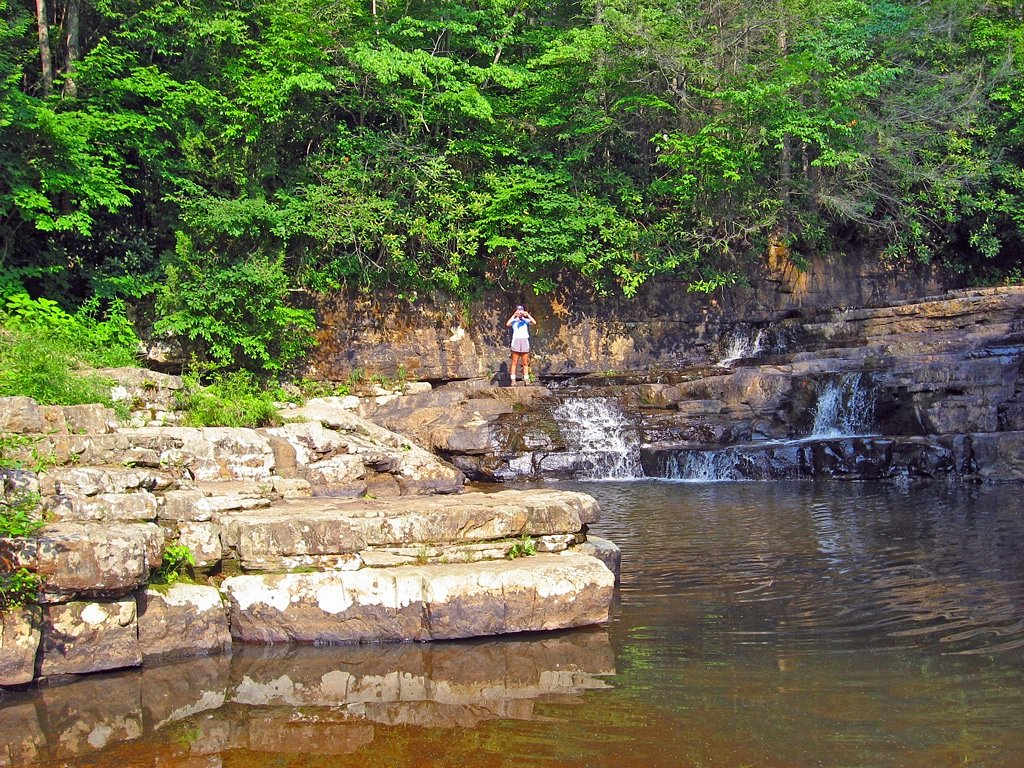
Falls of Dismal is a picturesque waterfall located in the Jefferson National Forest in Giles County, Virginia. It features a wide cascade over a rocky ledge into a serene pool below, making it a popular spot for nature enthusiasts and photographers.
The Setting
Falls of Dismal sits at 2,231 feet within Jefferson National Forest, fed by the Wolf Creek, in the hills of Virginia.
Trail & Hike Details
The Approach
The moderate hike follows Hoof & Hill (#1061), a 2.4-mile out-and-back trail over natural surface. Expect 350 feet of elevation gain with grades of +12-20%. The trail is developed (Class 3).
USFS Trail
HOOF & HILL #1061
Trail Class
Developed
Surface
Avg Grade
USFS Segment
2.01 miTrail Description
The trail to Falls of Dismal is short and relatively flat, making it accessible for most visitors. It follows Dismal Creek and offers scenic views of the surrounding forest. The trail is well-maintained and easy to navigate.
What to Expect
Swimming is permitted. Dogs are welcome.
Accessibility
The trail is not wheelchair accessible. Uneven terrain and elevation changes require steady footing.
Frequently Asked Questions
🐶 Are Dogs Allowed at Falls of Dismal?
✅ Dogs are allowed
Are There Any Fees or Permits Required?
🆖 No fees required
🏊 Is There Swimming at Falls of Dismal?
✅ Swimming is allowed
When to Visit
Spring and early summer are ideal for visiting, as the waterfall flow is typically strongest after seasonal rains.
Seasonal Access
The best time to visit is Spring, Summer, and Fall. Winter access may be limited. Check with Jefferson National Forest for seasonal road closures.
Safety Information
Rocks around the waterfall can be slippery, so exercise caution when exploring near the water. Be aware of changing water levels after heavy rain.
Current Water Conditions
45 ft³/s
Current discharge — how much water is flowing
Much lower than usual for this time of year
Based on 95 years of record
2.75 ft
Water depth at gauge
7-Day Discharge Trend
What does this mean for your visit?
Flow is well below normal for this time of year, so the waterfall may be a trickle.
About This Gauge
This gauge is on a nearby waterway and may not reflect exact conditions at the falls.
7-Day Flow Outlook
Based on the USGS gauge WOLF CREEK NEAR NARROWS, VA (14 km away).
Today
Barely Flowing
48 cfs
3/10Tomorrow
Low
55 cfs
3/10Sun
Low
59 cfs
3/10Mon
Low
55 cfs
3/10Tue
Barely Flowing
45 cfs
5/10Wed
Barely Flowing
41 cfs
5/10Thu
Low
45 cfs
3/10Best window: Tue — barely flowing flow, sunny (trip score 5/10).
Best time of year: this gauge typically runs highest from early February to mid April, peaking in March.
How we calculate this
This is a transparent outlook, not a precise forecast. We take the waterfall's current flow strength (how it ranks against its historical normal for today, from the nearest USGS stream gauge), carry that ranking forward along the gauge's seasonal curve, and nudge it for forecast rain. Confidence is highest for the next day or two and falls further out. Always check official conditions and your own judgment before visiting — high flows can be dangerous.
Know when to go.
Get a free email alert when waterfalls near Mechanicsburg hit peak flow. We only send when conditions are worth the trip — no weekly newsletters, no spam.
Weather Forecast
Location & Access
Getting There
Falls of Dismal is accessible via Dismal Creek Road (Route 671) in the Jefferson National Forest. The waterfall is located near the Appalachian Trail, and visitors can park nearby to access the short trail leading to the falls.
Get Directions on Google MapsParking
There is a small parking area near the trailhead on Dismal Creek Road. Parking may be limited during peak seasons.
Elevation
2,231 feet above sea level
Coordinates
37.188454° N, -80.900356° W
Land Management
Managed by USFS
Visitor Tips & Gear
Arrive early during weekends or peak seasons to secure parking. Wear sturdy shoes as the area around the falls can be slippery. Bring insect repellent during summer months.
As an Amazon Associate, we earn from qualifying purchases.
With 2.4 miles and 350 ft of elevation gain, sturdy boots and trekking poles will help on this moderate trail. Sun exposure on the trail makes good sun protection a must in summer.

Polarized Sunglasses (Knockaround)
Cuts glare off the water so you actually see the falls — and your photos turn out better too.

Columbia Watertight II Rain Jacket
Packs into its own pocket, seam-sealed, and keeps you dry from spray and surprise rain.

Earth Pak Waterproof Dry Bag
Keeps your phone and gear dry when waterfall mist soaks everything else.

Waterproof Phone Pouch (AiRunTech)
Cheap insurance — take photos right next to the falls without killing your phone.

Timberland Euro Sprint Mid Waterproof
Trusted waterproof boot with premium leather and grippy rubber sole — reliable on rocky, wet trails.

TrailBuddy Trekking Poles
Lightweight aluminum, cork grips, and flip-locks that actually hold — a best-seller for good reason.
Where to Stay

Country Inn & Suites by Radisson, Princeton, WV

Sleep Inn & Suites Princeton I-77

Sleep Inn Wytheville I-77 and I-81

Fairfield Inn & Suites by Marriott Princeton
Browse vacation cabins and private rentals nearby
Unique outdoor stays — tents, yurts, and treehouses
Rent a campervan or RV for your waterfall road trip
Some links are affiliate links. We may earn a commission at no extra cost to you.
Nearby Campground
STONY FORK CABIN
19.8 miles away · 1 sites
Overview Stony Fork Cabin is a cozy one-bedroom hideaway with most of the comforts of home. Visitors can hike, mountain bike, explore the many nearby creeks, or simply relax on the cabin's private patio. The cabin is located within the Stony Fork Campground along the Big Walker Mountain Scenic Byway. The Appalachian Trail, Seven Sisters Trail, and stocked fishing streams are all within a close proximity, and the site is easily accessed from I-77. State hunting and fishing regulations and licensin
Book on Recreation.govNearby Hot Springs
Hot springs near Mechanicsburg, Virginia
Alum Springs
Alum Springs flows at 72°F in Pulaski County, Virginia, emerging 18.4 degrees above the 53.6°F ambient temperature at 1,967 fee...

New River White Sulphur Springs
New River White Sulphur Springs produces 85-degree water that flows 30.3 degrees above ambient temperature at 1,780 feet elevat...

Old Sweet Spring
Old Sweet Spring flows at 73°F from a site 59.3 meters from Jefferson Lane in Greenbrier County, West Virginia. The spring emer...
Sweet Chalybeate Spring
Sweet Chalybeate Spring flows at 75 degrees Fahrenheit, emerging 21.1 degrees above ambient temperature at 2,010 feet elevation...
Looking for a soak after your hike? Explore more hot springs near Mechanicsburg, Virginia on SoakingSprings.
Explore Virginia springsAdditional Information
Nearby Attractions
The Appalachian Trail passes nearby, offering additional hiking opportunities. Dismal Falls Campground is also in the area for those interested in camping.
Wildlife
The area is home to a variety of wildlife, including birds, deer, and small mammals. Be cautious of snakes near the water.
Cities near Falls of Dismal
Writing about Falls of Dismal? Embed this waterfall on your site for free.