
Photo Credits (5)
Difficulty
Easy
Trail Length
1.2 miles
Trail Type
Out And Back
Elevation Gain
200 ft
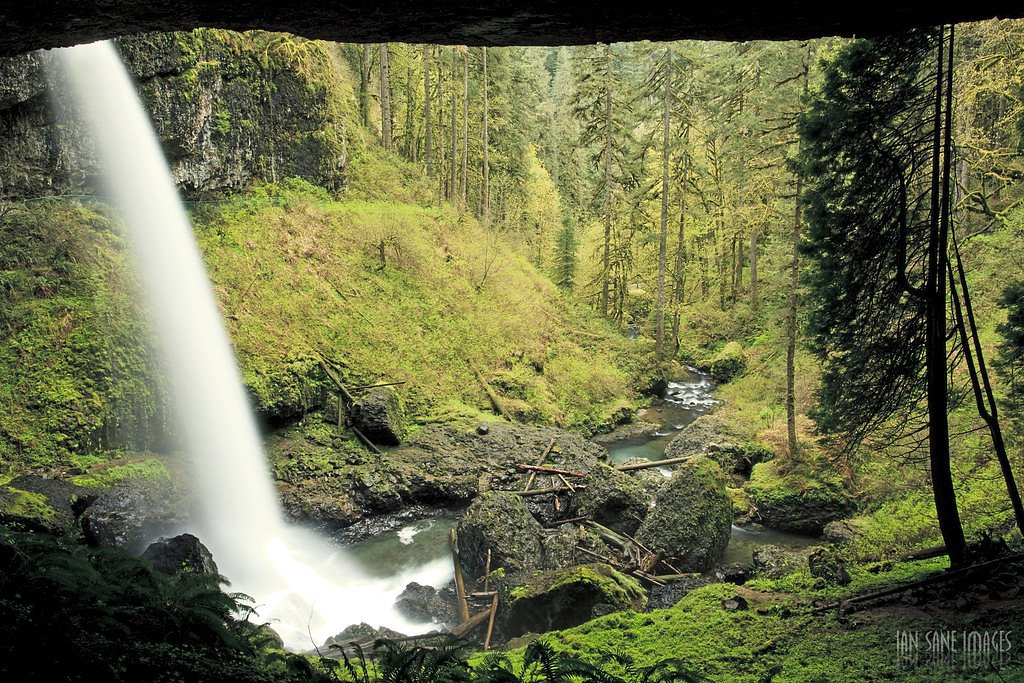
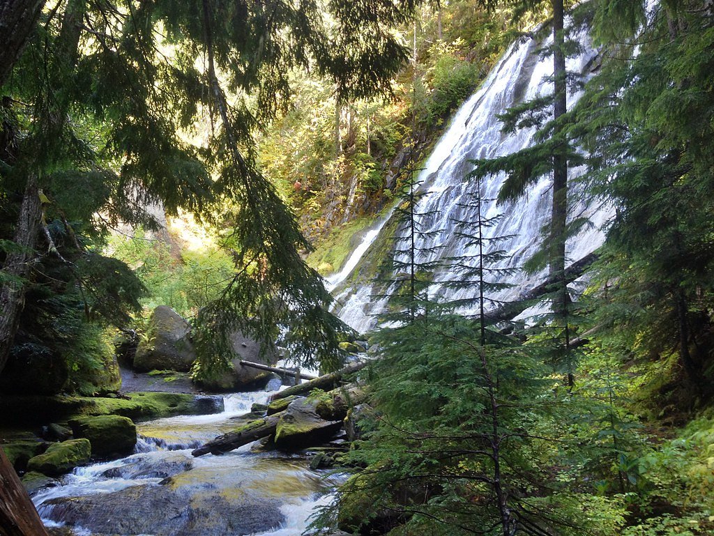
About Fall Creek Falls
Fall Creek Falls sits tucked into the mossy, conifer-dominated slopes of the Willamette National Forest and is managed by the U.S. Forest Service. The cascade drops through a lush forested amphitheater, offering a peaceful photo-worthy viewpoint that rewards a short walk from the trailhead. Visitors will find an approachable outing—perfect for families and anyone looking for a quick nature escape—along the well-marked Diamond Creek Falls Trail (USFS Trail #3598). The setting feels intimate and verdant year-round, with ferns and understory plants framing the stream and falls. Because the route is on Forest Service-managed land, expect native tread and natural trail features rather than paved boardwalks; modest elevation gain and a steady grade make this an inviting option for hikers who want a brief, restorative forest walk without a long backcountry commitment.
The Setting
Fall Creek Falls sits at 4,787 feet within Willamette National Forest, in the mountains of Oregon.
Trail & Hike Details
The Approach
The easy hike follows Diamond Creek Falls (#3598), a 1.2-mile out-and-back trail over natural surface. Expect 200 feet of elevation gain with grades of 12-20%. The trail is developed (Class 3).
USFS Trail
DIAMOND CREEK FALLS #3598
Trail Class
Developed
Surface
Avg Grade
USFS Segment
2.35 miTrail Description
The primary access to Fall Creek Falls follows the USFS Diamond Creek Falls Trail, Trail #3598. USFS data describe this route as a Class 3 trail with a native-material surface and a typical grade of 12–20%, so you’ll encounter firm but uneven tread and a few moderately steep pitches. USFS GIS records list the trail at about 2.35 miles, while common trail descriptions note roughly 1.2 miles of hiking with about 200 feet of elevation gain to reach viewpoints; the route is usually done as an out-and-back and is rated easy overall. Expect a natural soil-and-root trail rather than hardened surfaces, and plan for short sections that require stable footing. The combination of gentle overall elevation and native tread makes it a short, scenic hike—suitable for most hikers prepared for some uneven ground and modest climbs.
What to Expect
Dogs are welcome.
Accessibility
The trail is not wheelchair accessible. Uneven terrain and elevation changes require steady footing.
Frequently Asked Questions
🐶 Are Dogs Allowed at Fall Creek Falls?
✅ Dogs are allowed
Are There Any Fees or Permits Required?
🤑 Fee: $5.00
🏊 Is There Swimming at Fall Creek Falls?
❌ Swimming is not allowed
When to Visit
Spring and early summer are the best times to visit, as the waterfall is typically at its fullest due to snowmelt and rainfall.
Seasonal Access
The best time to visit is Spring, Summer, Fall, and Winter. Check with Willamette National Forest for seasonal road closures.
Safety Information
The trail can be slippery, especially after rain. Stay on the designated path and avoid climbing on rocks near the waterfall. Watch for poison oak along the trail.
Know when to go.
Get a free email alert when waterfalls near Crescent Lake hit peak flow. We only send when conditions are worth the trip — no weekly newsletters, no spam.
Weather Forecast
Location & Access
Getting There
Fall Creek Falls is located off Highway 138, also known as the Rogue-Umpqua Scenic Byway. From Roseburg, head east on Highway 138 for approximately 30 miles. Look for signs indicating the trailhead parking area.
Get Directions on Google MapsParking
There is a small parking area near the trailhead, but it may fill up during peak seasons. Arrive early to secure a spot.
Elevation
4,787 feet above sea level
Coordinates
43.592762° N, -122.138419° W
Land Management
Managed by USFS
Visitor Tips & Gear
Arrive early to avoid crowds, especially during weekends and holidays. Bring sturdy shoes, as the trail can be slippery in wet conditions. Consider visiting in spring when the waterfall flow is strongest.
As an Amazon Associate, we earn from qualifying purchases.
This easy 1.2 miles hike is straightforward — comfortable trail shoes and plenty of water should do. Icy conditions are common in winter — traction cleats are a smart addition.

Columbia Watertight II Rain Jacket
Packs into its own pocket, seam-sealed, and keeps you dry from spray and surprise rain.

Polarized Sunglasses (Knockaround)
Cuts glare off the water so you actually see the falls — and your photos turn out better too.

Earth Pak Waterproof Dry Bag
Keeps your phone and gear dry when waterfall mist soaks everything else.

Waterproof Phone Pouch (AiRunTech)
Cheap insurance — take photos right next to the falls without killing your phone.

Kahtoola MICROspikes
Cult-favorite traction cleats that grip ice and wet rock — essential for winter waterfall hikes.

JOBY GorillaPod Starter Kit
Wraps around railings and rocks for long-exposure waterfall shots — no flat surface needed.
Where to Stay

Shelter Cove Resort & Marina

Cascade Motel

Oakridge Inn & Suites

Westfir Lodge & Mountain Market
Browse vacation cabins and private rentals nearby
Unique outdoor stays — tents, yurts, and treehouses
Rent a campervan or RV for your waterfall road trip
Some links are affiliate links. We may earn a commission at no extra cost to you.
Nearby Campground
Crescent Lake Yurts
10.3 miles away · 3 sites
Overview The Crescent Lake Yurts are located within Crescent Lake Campground on the northwestern shore of Crescent Lake at the eastern base of the Cascade mountain range. Recreation The Crescent Lake area offers a wide-variety of recreation opportunities. The Crescent Lake Day Use Area provides boat launch access to the lake. Crescent Lake is a popular destination for boating, swimming, fishing and paddling. Fawn Lake Trailhead departs from the Crescent Lake Campground and Day Use Area providing
Book on Recreation.govNearby Hot Springs
Hot springs near Crescent Lake, Oregon

Mccredie Springs
McCredie Springs flows at 163°F along Salt Creek in the Willamette National Forest, creating one of western Oregon's most popul...
Kitson Hot Springs
Kitson Hot Springs flows at 109°F within Willamette National Forest at 1,664 feet elevation, positioned just 17 meters from For...
Wall Creek Warm Springs
Wall Creek Warm Springs flows at 106°F deep within Willamette National Forest at 2,362 feet elevation on the western Cascades s...

Umpqua Hot Springs
Umpqua Hot Springs flows at 117°F from multiple geothermal sources along the North Umpqua River in Lane County, forming cascadi...

Cougar Reservoir Hot Springs
Cougar Reservoir Hot Springs, widely known as Terwilliger Hot Springs, flows at 111 degrees Fahrenheit with roadside access req...
Foley Springs
Foley Springs emerges at 178°F in the Cascade Range of Lane County, making it one of Oregon's hottest thermal features with rec...
Looking for a soak after your hike? Explore more hot springs near Crescent Lake, Oregon on SoakingSprings.
Explore Oregon springsAdditional Information
Nearby Attractions
Nearby attractions include Toketee Falls, Watson Falls, and the Umpqua Hot Springs.
Wildlife
The area is home to various wildlife, including birds, deer, and small mammals. Keep an eye out for native flora and fauna along the trail.
Cities near Fall Creek Falls
Nearby Waterfalls

Other waterfalls named Fall Creek Falls
4 other waterfalls share this name across the U.S.
Writing about Fall Creek Falls? Embed this waterfall on your site for free.