Photo Credits (2)
Difficulty
Easy
Trail Length
1.5 miles
Trail Type
Out And Back
Elevation Gain
200 ft
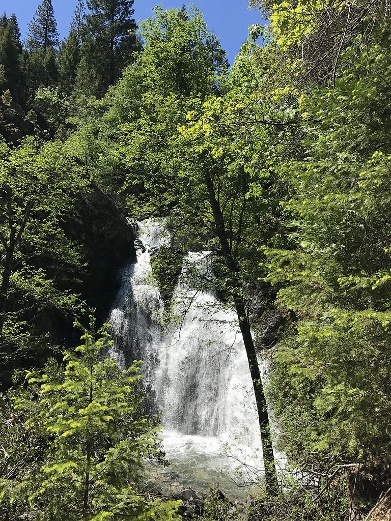
About Faery Falls
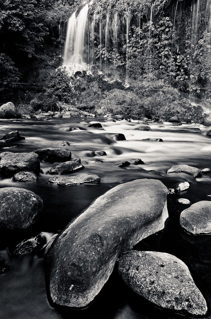
Faery Falls is a charming 50-foot cascade tucked in the Mount Shasta area on lands managed by the U.S. Forest Service within Shasta National Forest. The falls spill into a small, sheltered pool framed by dense forest, making it a favorite quick getaway for hikers and nature lovers. The U.S. Forest Service lists the route as FAIRY FALLS, Trail #04W25C, so you’re visiting a feature on designated NF land when you make the short trip. The broader region around Faery Falls includes classic northern California mountain features such as Castle Lake — a glacial cirque (tarn) west of Mount Shasta whose outlet drains via Castle Lake Creek into Lake Siskiyou and forms part of the headwaters of the Sacramento River; nearly all of Castle Lake sits within Shasta-Trinity National Forest. The setting is peaceful and accessible: most visitors describe the walk as an easy outing that rewards you with a photogenic cascade and quiet forest surroundings.
The Setting
Faery Falls sits at 3,281 feet within Shasta National Forest, in the mountains of California. The falls drop 50 feet.
Height: 50 feet
Trail & Hike Details
The Approach
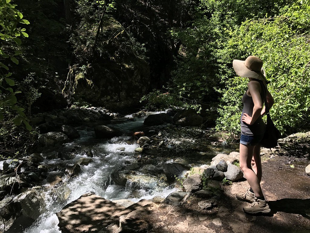
The easy hike follows Fairy Falls (#04W25C), a 1.5-mile out-and-back trail over natural surface. Expect 200 feet of elevation gain with grades of 5-8%. The trail is highly developed (Class 4).
USFS Trail
FAIRY FALLS #04W25C
Trail Class
Highly Developed
Surface
Avg Grade
USFS Segment
0.08 miTrail Description
The route to Faery Falls is commonly enjoyed as an easy 1.5-mile out-and-back with roughly 200 feet of elevation gain. The U.S. Forest Service maintains an official FAIRY FALLS Trail (Trail #04W25C) with a GIS-recorded length of 0.08 miles; that designated tread is native material, classified as Class 4, and typically grades about 5–8%. On the approach hikers follow old dirt road and native-surface tread through forested terrain to reach the waterfall; the short distance and modest gain make this a suitable short hike for most abilities.
What to Expect
The falls drop 50 feet. Dogs are welcome.
Accessibility
The trail is not wheelchair accessible. Uneven terrain and elevation changes require steady footing.
Frequently Asked Questions
🐶 Are Dogs Allowed at Faery Falls?
✅ Dogs are allowed
Are There Any Fees or Permits Required?
🆖 No fees required
🏊 Is There Swimming at Faery Falls?
❌ Swimming is not allowed
When to Visit
Spring is the best time to visit Faery Falls, as the water flow is strongest due to snowmelt. Summer and fall are also good times to visit, but the flow may be reduced. Winter access may be limited due to snow or muddy conditions.
Seasonal Access
The best time to visit is Spring, Summer, and Fall. Winter access may be limited. Check with Shasta National Forest for seasonal road closures.
Safety Information
The trail may be slippery after rain or during winter months. Visitors should exercise caution near the waterfall, as rocks can be wet and slippery. Always stay on marked trails to avoid getting lost.
Know when to go.
Get a free email alert when waterfalls near Mount Shasta hit peak flow. We only send when conditions are worth the trip — no weekly newsletters, no spam.
Weather Forecast
Location & Access
Getting There
Faery Falls is located near the town of Mount Shasta. To reach the trailhead, visitors typically drive to Ney Springs Road, which is accessible via Castle Lake Road. The road to the trailhead may be rough and unpaved, so a high-clearance vehicle is recommended.
Get Directions on Google MapsParking
Parking is available near the trailhead, but it is limited and may fill up during peak seasons. Visitors should park responsibly to avoid blocking the road.
Elevation
3,281 feet above sea level
Coordinates
41.261264° N, -122.335289° W
Land Management
Managed by USFS
Visitor Tips & Gear
Arrive early to secure parking, especially during weekends or holidays. Wear sturdy shoes as the trail may be uneven in some sections. Bring water and snacks, and pack out all trash to keep the area clean.
As an Amazon Associate, we earn from qualifying purchases.
This easy 1.5 miles hike is straightforward — comfortable trail shoes and plenty of water should do. Sun exposure on the trail makes good sun protection a must in summer.

Polarized Sunglasses (Knockaround)
Cuts glare off the water so you actually see the falls — and your photos turn out better too.

Columbia Watertight II Rain Jacket
Packs into its own pocket, seam-sealed, and keeps you dry from spray and surprise rain.

Earth Pak Waterproof Dry Bag
Keeps your phone and gear dry when waterfall mist soaks everything else.

Waterproof Phone Pouch (AiRunTech)
Cheap insurance — take photos right next to the falls without killing your phone.

JOBY GorillaPod Starter Kit
Wraps around railings and rocks for long-exposure waterfall shots — no flat surface needed.

Osprey Daylite Daypack
Light, organized, and just the right size for a day hike — fits water, snacks, and layers.
Where to Stay

Inn At Mount Shasta

Mount Shasta Resort

Cold Creek Inn

Swiss Holiday Lodge
Browse vacation cabins and private rentals nearby
Unique outdoor stays — tents, yurts, and treehouses
Rent a campervan or RV for your waterfall road trip
Some links are affiliate links. We may earn a commission at no extra cost to you.
Nearby Campground
RED FIR FLAT GROUP CAMPGROUND
7.1 miles away · 1 sites
Overview Red Fir Flat Group Campground is located on the southern slope of Mt. Shasta at 6,400 feet in elevation. Snowpack in this location may extend into late June on heavy snow years, and usually sees late season snowfall in early November, possibly October. It is a popular site for meditation/retreat groups. Maximum stay limit is 7 days per group and or indvidual(s) Recreation Most visitors enjoy the peace and solitude of the forest setting. Several hiking trails are located nearby, including
Book on Recreation.govNearby Hot Springs
Hot springs near Mount Shasta, California

Hot Spring, Fumaroles
Hot Spring with fumaroles on Mount Shasta at 14,000 feet elevation represents one of California's highest thermal features, wit...
Hunt Hot Spring
Hunt Hot Spring produces 136-degree water from the forested slopes near McCloud in Siskiyou County at just 1,712 feet elevation...
Big Bend Hot Springs
Big Bend Hot Springs surges at a scalding 180 degrees Fahrenheit from volcanic terrain at just 1,644 feet elevation, creating o...
Big Bend, California
Big Bend sits along a dramatic curve of the Pit River in Shasta County at 1,720 feet elevation, occupying territory historicall...
Bogus Soda Springs
Bogus Soda Springs flows at 76°F from Siskiyou County's volcanic landscape at 2,801 feet elevation. The name suggests early ske...
Klamath Hot Spring
Klamath Hot Spring discharges at 156°F just 27 feet from the nearest road near Montague in Siskiyou County, making it extraordi...
Looking for a soak after your hike? Explore more hot springs near Mount Shasta, California on SoakingSprings.
Explore California springsAdditional Information
Nearby Attractions
Nearby attractions include Castle Lake, Lake Siskiyou, and the town of Mount Shasta, which offers shops, restaurants, and other outdoor activities.
Wildlife
The area is home to a variety of wildlife, including birds, deer, and small mammals. Visitors should be cautious of ticks and other insects.
Cities near Faery Falls
Nearby Waterfalls
Writing about Faery Falls? Embed this waterfall on your site for free.