Deer Creek Falls
Arizona • Grand Canyon National Park • 150 ft
By Armen Suny · Last verified Mar 2026
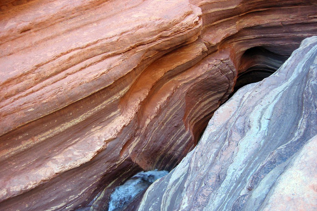
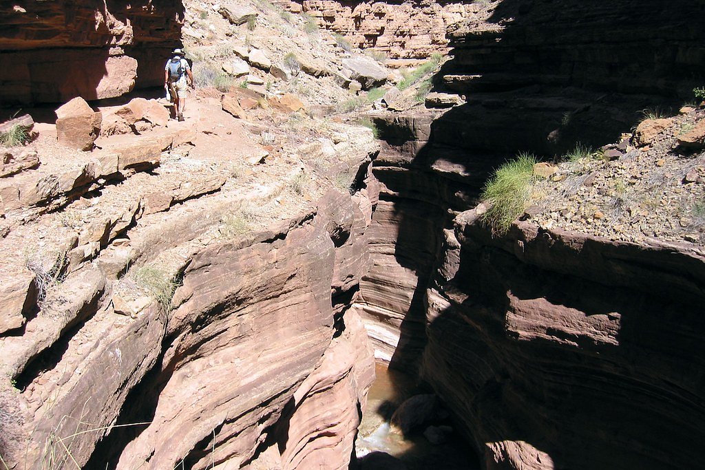
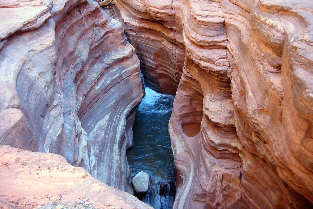
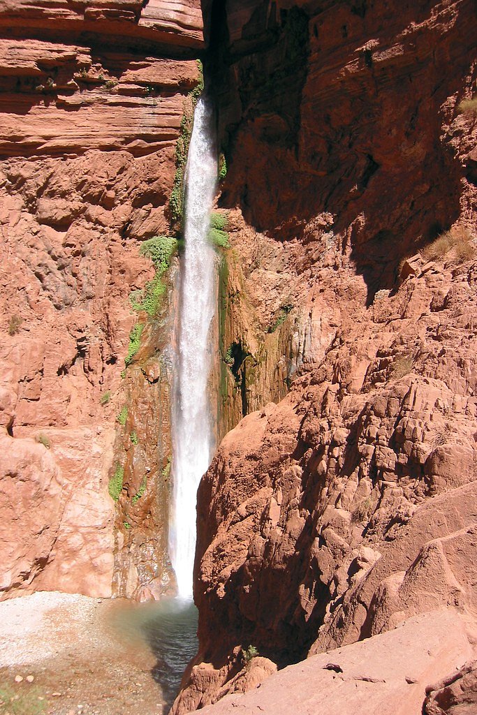

Photo Credits (5)
Difficulty
Hard
Trail Length
14.0 miles
Trail Type
Out And Back
Elevation Gain
4 ft
About Deer Creek Falls
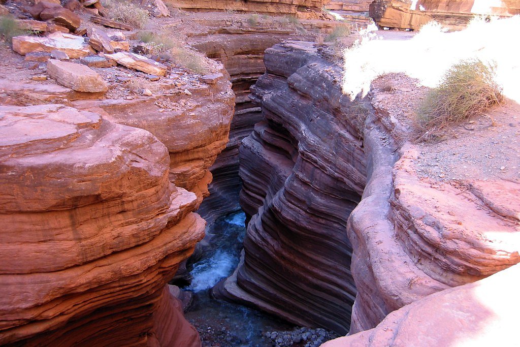
Deer Creek Falls is a dramatic 150-foot cascade where Deer Creek — a right-bank tributary of the Colorado River — plunges out of a narrow slot canyon in the western Grand Canyon. Nestled within Grand Canyon National Park and managed by the National Park Service, the falls are fed by a series of natural springs that give Deer Creek a perennial flow, creating a lush ribbon of water and vegetation amid the desert cliffs. In the final half mile above the river the creek funnels through a tight slot before tumbling over the cliff, producing one of the canyon’s most photogenic waterfalls. The setting feels remote and rewardingly wild: the falls are best appreciated by visitors prepared for a long, strenuous approach and who respect the canyon’s hazards. Deer Creek’s reliable springs sustain the oasis-like pools, but the stream is also prone to severe flash flooding during periods of intense rainfall, so timing and weather awareness are critical when planning a visit to this iconic Grand Canyon feature.
The Setting
Deer Creek Falls sits at 2,228 feet within Grand Canyon National Park, fed by the Havasu Creek, in the hills of Arizona. At 150 feet, it is among the taller waterfalls in Arizona.
Height: 150 feet
Trail & Hike Details
The Approach
The hard 14.0-mile out-and-back trail gains 4 feet of elevation on the way to the falls.
Trail Description
Access to Deer Creek Falls requires a long, strenuous out-and-back route (trail length: 14.0 miles) with a reported difficulty of hard and minimal net elevation gain (listed as 4 feet). Hikers descend into the Grand Canyon and must negotiate steep switchbacks, rocky and exposed sections, and the rugged approach that culminates in the narrow slot canyon in the final half mile before the falls. Trail users should plan for remote backcountry travel, carry appropriate navigation and water treatment gear, and be vigilant for flash-flood conditions in the canyon. Note: this route is within Grand Canyon National Park (NPS).
What to Expect
The falls cascade 150 feet. Swimming is permitted.
Accessibility
The trail involves steep, uneven terrain with significant elevation change and is not accessible to mobility devices.
Frequently Asked Questions
🐶 Are Dogs Allowed at Deer Creek Falls?
❌ Dogs are not allowed
Are There Any Fees or Permits Required?
🤑 Fee: $35.00
Permit required
A backcountry permit is required for overnight hiking trips in the Grand Canyon. Permits can be obtained through the Grand Canyon National Park Backcountry Information Center. For rafting trips, permits are also required and must be secured well in advance.
🏊 Is There Swimming at Deer Creek Falls?
✅ Swimming is allowed
When to Visit
Spring and fall are the best times to visit due to milder temperatures. Summer can be extremely hot, and winter conditions may make access more challenging.
Seasonal Access
The best time to visit is Spring, Summer, and Fall. Winter access may be limited. Watch for flash flood warnings during monsoon season (July through September). Check with Grand Canyon National Park for current conditions.
Safety Information
This is a remote and challenging area. Be prepared for extreme heat, limited water sources, and rugged terrain. Always inform someone of your plans and carry a satellite communication device if hiking. River currents near the falls can be strong, so exercise caution when swimming.
Current Water Conditions
Based on a USGS gauge 15.2 miles away
63 ft³/s
Current discharge — how much water is flowing
Much lower than usual for this time of year
Based on 25 years of record
6.96 ft
Water depth at gauge
7-Day Discharge Trend
What does this mean for your visit?
Flow is well below normal for this time of year, so the waterfall may be a trickle.
About This Gauge
This gauge is on a regional waterway. Conditions at the falls may differ, especially after local rain.
7-Day Flow Outlook
Based on the USGS gauge HAVASU CREEK ABOVE THE MOUTH, NEAR SUPAI, AZ (25 km away).
Today
Low
73 cfs
3/10Tomorrow
Low
77 cfs
3/10Fri
Barely Flowing
68 cfs
5/10Sat
Barely Flowing
64 cfs
5/10Sun
Barely Flowing
64 cfs
5/10Mon
Barely Flowing
64 cfs
5/10Tue
Barely Flowing
64 cfs
5/10Best window: Fri — barely flowing flow, sunny (trip score 5/10).
Best time of year: this gauge typically runs highest from early March to late March, peaking in August.
How we calculate this
This is a transparent outlook, not a precise forecast. We take the waterfall's current flow strength (how it ranks against its historical normal for today, from the nearest USGS stream gauge), carry that ranking forward along the gauge's seasonal curve, and nudge it for forecast rain. Confidence is highest for the next day or two and falls further out. Always check official conditions and your own judgment before visiting — high flows can be dangerous.
Know when to go.
Get a free email alert when waterfalls near Fredonia hit peak flow. We only send when conditions are worth the trip — no weekly newsletters, no spam.
Weather Forecast
Location & Access
Getting There
Deer Creek Falls is most commonly accessed via rafting trips on the Colorado River. It can also be reached by hiking, though this requires a challenging and remote trek through the Grand Canyon. The nearest trailhead is the Bill Hall Trailhead, which connects to the Deer Creek Trail.
Get Directions on Google MapsParking
Parking is available at the Bill Hall Trailhead, but access to this area requires a high-clearance vehicle and careful navigation of remote roads.
Elevation
2,228 feet above sea level
Coordinates
36.389475° N, -112.508168° W
Land Management
Managed by NPS
Visitor Tips & Gear
Plan your trip carefully and be prepared for remote conditions. Bring plenty of water, sun protection, and sturdy footwear. If hiking, start early to avoid the heat and allow ample time for the strenuous trek. If rafting, coordinate with your group to ensure a safe and enjoyable visit.
As an Amazon Associate, we earn from qualifying purchases.
This challenging 14.0 miles trail gains 4 ft in elevation — come prepared with proper hiking boots and trekking poles. Sun exposure on the trail makes good sun protection a must in summer.
America the Beautiful Annual Pass
Covers entrance fees at 2,000+ federal recreation sites — required at most National Parks.

Sawyer Squeeze Water Filter
The backcountry standard — filters 99.9% of bacteria and weighs just 3 oz.

Polarized Sunglasses (Knockaround)
Cuts glare off the water so you actually see the falls — and your photos turn out better too.

Columbia Watertight II Rain Jacket
Packs into its own pocket, seam-sealed, and keeps you dry from spray and surprise rain.

Earth Pak Waterproof Dry Bag
Keeps your phone and gear dry when waterfall mist soaks everything else.

Waterproof Phone Pouch (AiRunTech)
Cheap insurance — take photos right next to the falls without killing your phone.

Timberland Euro Sprint Mid Waterproof
Trusted waterproof boot with premium leather and grippy rubber sole — reliable on rocky, wet trails.
Where to Stay
Browse vacation cabins and private rentals nearby
Unique outdoor stays — tents, yurts, and treehouses
Rent a campervan or RV for your waterfall road trip
Some links are affiliate links. We may earn a commission at no extra cost to you.
Nearby Campground
JUMPUP CABIN
13.7 miles away · 1 sites
Overview Since the 1900s, Jumpup cabin has been used by ranchers as well as the Forest Service, and is listed on the National Register of Historic Places. The site consists of a historic two-room cabin, shed and composting toilet. Recreation Jumpup cabin is located at the trailhead for the Ranger trail, a 17-mile wilderness trail that winds through Kanab Creek. Hiking this area is very popular in the spring and fall months, but is discouraged during the hottest summer months. Water is scarce and
Book on Recreation.govNearby Hot Springs
Hot springs near Fredonia, Arizona
Colorado Pool
Colorado Pool flows at 86 degrees Fahrenheit near the Grand Canyon in Coconino County at 2,912 feet elevation, requiring approx...

Lava Warm Springs
Lava Warm Springs flows at 90°F on the Hualapai Indian Reservation in Mohave County near Peach Springs, emerging 20 degrees war...
Pumpkin Spring
Pumpkin Spring emerges as a mineralized thermal feature in the Grand Canyon's depths, located on the Hualapai Indian Reservatio...
Looking for a soak after your hike? Explore more hot springs near Fredonia, Arizona on SoakingSprings.
Explore Arizona springsAdditional Information
Nearby Attractions
Other notable stops along the Colorado River include Havasu Creek, Tapeats Creek, and Thunder River.
Wildlife
The area is home to a variety of wildlife, including bighorn sheep, lizards, and birds. Be cautious of snakes and other desert creatures.
Cities near Deer Creek Falls
Other waterfalls named Deer Creek Falls
3 other waterfalls share this name across the U.S.
Writing about Deer Creek Falls? Embed this waterfall on your site for free.