Difficulty
Moderate
Trail Length
2.4 miles
Trail Type
Out And Back
Elevation Gain
350 ft
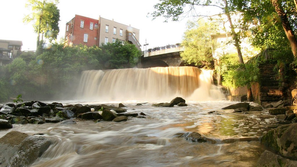
About Deans Fall
Deans Fall is a quietly picturesque waterfall in Ohio that draws hikers and photographers looking for a peaceful natural setting and the sound of cascading water. Framed by wooded slopes and accessible without technical gear, the fall makes for a rewarding short-day outing and a lovely spot to pause and enjoy the quiet of the forest. The most common access follows a 2.4-mile out-and-back route that climbs about 350 feet, rated moderate—a manageable hike for most scrambles and stair-free trekking with a bit of elevation. While there aren’t nearby formal campgrounds within a short walk, the nearest established picnic shelters and camping facilities are roughly 35 kilometers away at Cuyahoga Valley National Park, so plan day trips accordingly.
Trail & Hike Details
The Approach
The moderate 2.4-mile out and back trail gains 350 feet of elevation on the way to the falls.
Trail Description
The primary approach to Deans Fall is a 2.4-mile out-and-back trail with approximately 350 feet of elevation gain and a moderate difficulty rating. The route is best treated as a short day hike—expect a steady climb on the return and variable footing depending on recent weather. Hikers should wear sturdy shoes, bring water, and allow time to enjoy the falls; check local trail reports before heading out for the latest condition updates.
What to Expect
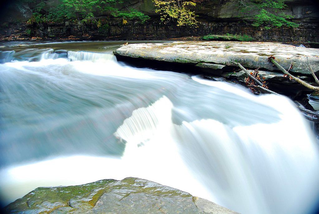
Visitors can expect a tranquil natural setting with a scenic waterfall. The area may have uneven terrain and limited facilities.
Accessibility
The trail is not wheelchair accessible. Uneven terrain and elevation changes require steady footing.
Frequently Asked Questions
🐶 Are Dogs Allowed at Deans Fall?
❌ Dogs are not allowed
Are There Any Fees or Permits Required?
🆖 No fees required
🏊 Is There Swimming at Deans Fall?
❌ Swimming is not allowed
When to Visit
Spring and fall are typically the best times to visit, as the waterfall may have higher water flow during these seasons.
Seasonal Access
The best time to visit is Spring, Summer, and Fall. Winter access may be limited.
Safety Information
Visitors should be cautious of slippery rocks, uneven terrain, and changing weather conditions. Always stay on marked trails if available.
Current Water Conditions
0.79 ft
Water depth at gauge
About This Gauge
7-Day Flow Outlook
Based on the USGS gauge Unnamed trib to Chagrin R at Mayfield Village OH (5 km away).
Best time of year: this gauge typically runs highest from mid February to mid March, peaking in August.
How we calculate this
This is a transparent outlook, not a precise forecast. We take the waterfall's current flow strength (how it ranks against its historical normal for today, from the nearest USGS stream gauge), carry that ranking forward along the gauge's seasonal curve, and nudge it for forecast rain. Confidence is highest for the next day or two and falls further out. Always check official conditions and your own judgment before visiting — high flows can be dangerous.
Know when to go.
Get a free email alert when waterfalls near Gates Mills hit peak flow. We only send when conditions are worth the trip — no weekly newsletters, no spam.
Weather Forecast
Location & Access
Getting There
The exact location and directions to Deans Fall are not well-documented. Visitors are advised to consult local resources or hiking guides for accurate directions.
Get Directions on Google MapsParking
Parking availability is unclear. Visitors should check with local authorities or nearby parks for parking options.
Hours
Elevation
961 feet above sea level
Coordinates
41.520800° N, -81.390100° W
Visitor Tips & Gear
Bring sturdy footwear and be prepared for potential changes in trail conditions. Check weather forecasts before visiting.
As an Amazon Associate, we earn from qualifying purchases.
With 2.4 miles and 350 ft of elevation gain, sturdy boots and trekking poles will help on this moderate trail. Sun exposure on the trail makes good sun protection a must in summer.

Columbia Watertight II Rain Jacket
Packs into its own pocket, seam-sealed, and keeps you dry from spray and surprise rain.

Earth Pak Waterproof Dry Bag
Keeps your phone and gear dry when waterfall mist soaks everything else.

Waterproof Phone Pouch (AiRunTech)
Cheap insurance — take photos right next to the falls without killing your phone.

Timberland Euro Sprint Mid Waterproof
Trusted waterproof boot with premium leather and grippy rubber sole — reliable on rocky, wet trails.

TrailBuddy Trekking Poles
Lightweight aluminum, cork grips, and flip-locks that actually hold — a best-seller for good reason.

Polarized Sunglasses (Knockaround)
Cuts glare off the water so you actually see the falls — and your photos turn out better too.
Where to Stay

Comfort Inn Mayfield Heights Cleveland East

Holiday Inn Cleveland-Mayfield by IHG

Hampton Inn & Suites Cleveland-Beachwood

Hampton Inn Cleveland-Solon
Browse vacation cabins and private rentals nearby
Unique outdoor stays — tents, yurts, and treehouses
Rent a campervan or RV for your waterfall road trip
Some links are affiliate links. We may earn a commission at no extra cost to you.
Nearby Campground
CUYAHOGA VALLEY NATIONAL PARK PICNIC SHELTERS
21.8 miles away · 2 sites
Overview Cuyahoga Valley National Park is a destination for millions of visitors each year who enjoy hiking, riding the Cuyahoga Valley Scenic Railroad , biking and picnicking. Whether you need an area large enough for a family reunion or just an intimate spot for two, Cuyahoga Valley is an ideal destination. Picnic areas are scattered throughout the park. Two rustic shelters, Ledges and Octagon, are available for reservation in the Virginia Kendall Unit of Cuyahoga Valley National Park. Recreati
Book on Recreation.govAdditional Information
Nearby Attractions
Nearby attractions are not well-documented. Visitors may explore other natural areas or parks in the region.
Wildlife
The area may host typical Ohio wildlife, including birds, deer, and small mammals.
Cities near Deans Fall
Nearby Waterfalls
Writing about Deans Fall? Embed this waterfall on your site for free.