
Photo Credits (3)
Difficulty
Moderate
Trail Length
3.0 miles
Trail Type
Out And Back
Elevation Gain
500 ft
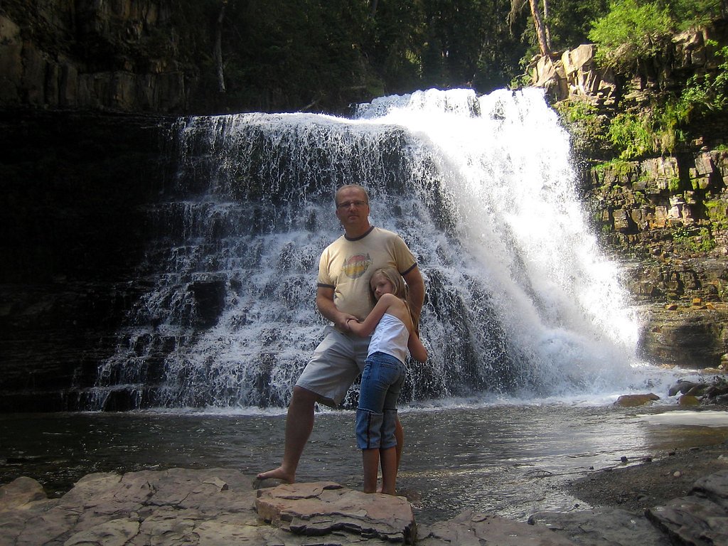
About Dean Falls
Dean Falls is a tucked-away cascade in Montana’s Flathead National Forest, managed by the U.S. Forest Service. The falls are reached via the Spotted Bear River Trail (USFS Trail #83), and because it sees fewer visitors than nearby destinations the setting feels peaceful and forested—an inviting stop for hikers who enjoy quiet river corridors and old-growth stands. The approach is a moderate outing: the commonly used route is a 3.0-mile out-and-back with about 500 feet of elevation gain, making it a good half-day hike for most fit day-trippers. For those planning to stay nearby, the Silvertip Cabin campground is about 7.67 km from the falls, offering a convenient option for an overnight in the National Forest after a day on the trail. Remember that this is a U.S. Forest Service-managed area (Flathead National Forest), so standard backcountry etiquette and Leave No Trace practices help keep the place pristine for everyone.
The Setting
Dean Falls sits at 4,616 feet within Flathead National Forest, in the mountains of Montana.
Trail & Hike Details
The Approach
The moderate hike follows Spotted Bear River (#83), a 3.0-mile out-and-back trail over natural surface. Expect 500 feet of elevation gain with grades of 12-20%. The trail is developed (Class 3).
USFS Trail
SPOTTED BEAR RIVER #83
Trail Class
Developed
Surface
Avg Grade
USFS Segment
0.90 miTrail Description
The route to Dean Falls follows USFS Spotted Bear River Trail (#83). According to Forest Service trail data the trail is classified as Class 3, with a native material surface and typical grade between 12–20%. The commonly hiked route is a moderate 3.0-mile out-and-back with roughly 500 feet of elevation gain; the dataset records the trail at 0.9 GIS miles for the mapped segment. Expect a natural tread of dirt, roots and occasional rocks—sturdy footwear is recommended—and moderate grades that can be steep in short sections.
What to Expect
Visitors can expect a tranquil setting with the sound of cascading water and lush greenery. The area around the falls may be slippery, so caution is advised. Wildlife sightings are possible, including birds and small mammals.
Accessibility
The trail is not wheelchair accessible. Uneven terrain and elevation changes require steady footing.
Frequently Asked Questions
🐶 Are Dogs Allowed at Dean Falls?
❌ Dogs are not allowed
Are There Any Fees or Permits Required?
🆖 No fees required
🏊 Is There Swimming at Dean Falls?
❌ Swimming is not allowed
When to Visit
Spring and early summer are ideal for visiting Dean Falls, as the water flow is typically strongest during this time. Fall offers beautiful foliage, while summer provides warmer weather for hiking.
Seasonal Access
The best time to visit is Spring, Summer, and Fall. Winter access may be limited. Check with Flathead National Forest for seasonal road closures.
Safety Information
Be cautious of slippery rocks near the waterfall. Carry bear spray and make noise while hiking to avoid surprising wildlife. Check weather conditions before your trip, as trails may become muddy or impassable after rain.
Current Water Conditions
Based on a USGS gauge 17.6 miles away
3,740 ft³/s
Current discharge — how much water is flowing
About average for this time of year
Based on 52 years of record
7.85 ft
Water depth at gauge
52°F
ColdBracing — limit time in water
7-Day Discharge Trend
What does this mean for your visit?
Flow is about average for this time of year. Water temperature is a bracing 52 degrees F, limit your time in the water.
About This Gauge
This gauge is on a regional waterway. Conditions at the falls may differ, especially after local rain.
7-Day Flow Outlook
Based on the USGS gauge S F Flathead R ab Twin C nr Hungry Horse MT (28 km away).
Today
Low
4321 cfs
3/10Tomorrow
Low
4094 cfs
4/10Mon
Low
4002 cfs
3/10Tue
Low
3742 cfs
4/10Wed
Barely Flowing
3145 cfs
5/10Thu
Low
3282 cfs
3/10Fri
Moderate
3335 cfs
4/10Best window: Wed — barely flowing flow, mostly sunny (trip score 5/10).
Best time of year: this gauge typically runs highest from mid April to mid July, peaking in June.
How we calculate this
This is a transparent outlook, not a precise forecast. We take the waterfall's current flow strength (how it ranks against its historical normal for today, from the nearest USGS stream gauge), carry that ranking forward along the gauge's seasonal curve, and nudge it for forecast rain. Confidence is highest for the next day or two and falls further out. Always check official conditions and your own judgment before visiting — high flows can be dangerous.
Know when to go.
Get a free email alert when waterfalls near Swan Lake hit peak flow. We only send when conditions are worth the trip — no weekly newsletters, no spam.
Weather Forecast
Location & Access
Getting There
Dean Falls is located in a remote area of Montana. Specific directions may vary depending on your starting point, and it is recommended to use a reliable map or GPS. The trailhead is typically accessed via forest roads, which may require a high-clearance vehicle.
Get Directions on Google MapsParking
Parking availability is limited and may consist of a small dirt lot or roadside parking near the trailhead.
Elevation
4,616 feet above sea level
Coordinates
47.877445° N, -113.212292° W
Land Management
Managed by USFS
Visitor Tips & Gear
Start your hike early to avoid crowds and ensure you have enough daylight for the return trip. Bring plenty of water, snacks, and a map or GPS device. Cell service may be unreliable in the area.
As an Amazon Associate, we earn from qualifying purchases.
With 3.0 miles and 500 ft of elevation gain, sturdy boots and trekking poles will help on this moderate trail. Sun exposure on the trail makes good sun protection a must in summer.

Polarized Sunglasses (Knockaround)
Cuts glare off the water so you actually see the falls — and your photos turn out better too.

Columbia Watertight II Rain Jacket
Packs into its own pocket, seam-sealed, and keeps you dry from spray and surprise rain.

Earth Pak Waterproof Dry Bag
Keeps your phone and gear dry when waterfall mist soaks everything else.

Waterproof Phone Pouch (AiRunTech)
Cheap insurance — take photos right next to the falls without killing your phone.

Timberland Euro Sprint Mid Waterproof
Trusted waterproof boot with premium leather and grippy rubber sole — reliable on rocky, wet trails.

TrailBuddy Trekking Poles
Lightweight aluminum, cork grips, and flip-locks that actually hold — a best-seller for good reason.
Where to Stay

Browse vacation cabins and private rentals nearby
Unique outdoor stays — tents, yurts, and treehouses
Rent a campervan or RV for your waterfall road trip
Some links are affiliate links. We may earn a commission at no extra cost to you.
Nearby Campground
SILVERTIP CABIN
4.8 miles away · 1 sites
Overview The remote Silvertip Cabin serves as an ideal base for accessing various hiking and horseback riding trails to the Great Bear and Bob Marshall Wilderness areas. Located 70 miles south of the town of Hungry Horse, up to eight guests can enjoy the comforts of the cabin's mattress-covered beds and warm up by the wood stove following various wilderness adventures. The cabin is only available on weekends from early July until August, or sometimes the first weekend of September. Access require
Book on Recreation.govNearby Hot Springs
Hot springs near Swan Lake, Montana
Looking for a soak after your hike? Explore more hot springs near Swan Lake, Montana on SoakingSprings.
Explore Montana springsAdditional Information
Nearby Attractions
Other hiking trails and natural attractions in the surrounding area may be worth exploring.
Wildlife
The area is home to various wildlife, including deer, birds, and small mammals. Be cautious of bears and carry bear spray if hiking in bear country.
Cities near Dean Falls
Writing about Dean Falls? Embed this waterfall on your site for free.