Photo Credits (5)
Difficulty
Moderate
Trail Length
2.4 miles
Trail Type
Out And Back
Elevation Gain
350 ft
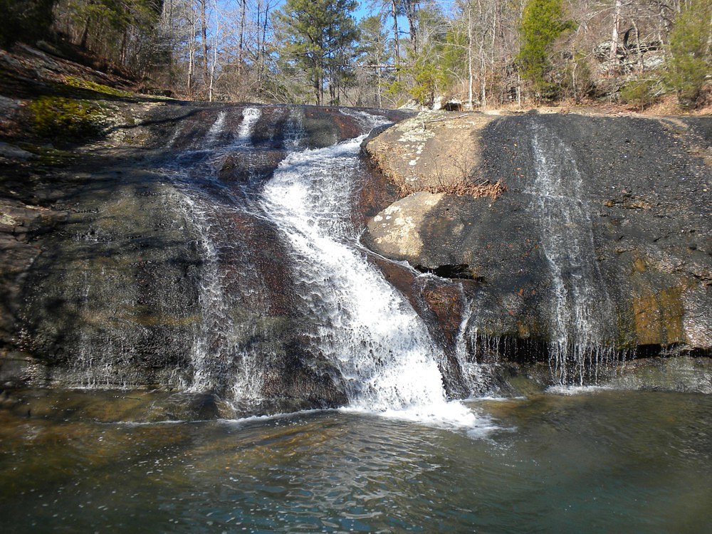
About Davis Falls
Davis Falls is a small but picturesque waterfall located in Alabama. It is known for its serene surroundings and is a popular spot for nature enthusiasts and photographers. The waterfall may be seasonal, with the best flow typically occurring after rainfall.
The Setting
Davis Falls sits at 469 feet along the Little Cahaba River, in the coastal lowlands of Alabama.
Trail & Hike Details
The Approach
The moderate 2.4-mile out-and-back trail gains 350 feet of elevation on the way to the falls.
Trail Description
The trail to Davis Falls, if present, is not well-documented. Visitors should be prepared for potentially uneven terrain and verify access conditions before visiting.
What to Expect
Visitors can expect a peaceful natural setting with a small waterfall. The flow of the falls may vary depending on recent rainfall. The area may not have developed facilities.
Accessibility
The trail is not wheelchair accessible. Uneven terrain and elevation changes require steady footing.
Frequently Asked Questions
🐶 Are Dogs Allowed at Davis Falls?
❌ Dogs are not allowed
Are There Any Fees or Permits Required?
🆖 No fees required
🏊 Is There Swimming at Davis Falls?
❌ Swimming is not allowed
When to Visit
The best time to visit is typically after rainfall, especially in spring or fall when the weather is mild.
Seasonal Access
The best time to visit is Spring, Summer, and Fall. Winter access may be limited.
Safety Information
Visitors should be cautious of slippery rocks near the waterfall and avoid visiting during heavy rain or flooding conditions. Cell service may be limited, so plan accordingly.
Current Water Conditions
63 ft³/s
Current discharge — how much water is flowing
Lower than usual for this time of year
Based on 3 years of record
1.74 ft
Water depth at gauge
7-Day Discharge Trend
What does this mean for your visit?
Flow is lower than usual for this time of year.
About This Gauge
This gauge is on a nearby waterway and may not reflect exact conditions at the falls.
7-Day Flow Outlook
Based on the USGS gauge LITTLE CAHABA RIVER NEAR BRIERFIELD AL (8 km away).
Today
Low
63 cfs
6/10Tomorrow
Moderate
69 cfs
4/10Thu
Low
68 cfs
6/10Fri
Low
64 cfs
6/10Sat
Moderate
70 cfs
4/10Sun
Moderate
70 cfs
4/10Mon
Moderate
71 cfs
4/10Best window: Today — low flow, sunny (trip score 6/10).
Best time of year: this gauge typically runs highest from early March to mid April, peaking in February.
How we calculate this
This is a transparent outlook, not a precise forecast. We take the waterfall's current flow strength (how it ranks against its historical normal for today, from the nearest USGS stream gauge), carry that ranking forward along the gauge's seasonal curve, and nudge it for forecast rain. Confidence is highest for the next day or two and falls further out. Always check official conditions and your own judgment before visiting — high flows can be dangerous.
Know when to go.
Get a free email alert when waterfalls near Montevallo hit peak flow. We only send when conditions are worth the trip — no weekly newsletters, no spam.
Weather Forecast
Location & Access
Getting There
Davis Falls is located near the town of Montevallo, Alabama. Access to the falls may require navigating local roads and potentially a short walk from a parking area. Specific directions should be confirmed before visiting.
Get Directions on Google MapsParking
Parking availability is unclear, but visitors may need to park along nearby roads or in designated areas if available.
Elevation
469 feet above sea level
Coordinates
33.117619° N, -86.897212° W
Visitor Tips & Gear
Check weather conditions before visiting, as the waterfall's flow may depend on recent rain. Wear sturdy footwear and bring water. Cell service may be limited in the area.
As an Amazon Associate, we earn from qualifying purchases.
With 2.4 miles and 350 ft of elevation gain, sturdy boots and trekking poles will help on this moderate trail. Sun exposure on the trail makes good sun protection a must in summer.

Polarized Sunglasses (Knockaround)
Cuts glare off the water so you actually see the falls — and your photos turn out better too.

Columbia Watertight II Rain Jacket
Packs into its own pocket, seam-sealed, and keeps you dry from spray and surprise rain.

Earth Pak Waterproof Dry Bag
Keeps your phone and gear dry when waterfall mist soaks everything else.

Waterproof Phone Pouch (AiRunTech)
Cheap insurance — take photos right next to the falls without killing your phone.

Timberland Euro Sprint Mid Waterproof
Trusted waterproof boot with premium leather and grippy rubber sole — reliable on rocky, wet trails.

TrailBuddy Trekking Poles
Lightweight aluminum, cork grips, and flip-locks that actually hold — a best-seller for good reason.
Where to Stay

Candlewood Suites Alabaster by IHG

Spark by Hilton Pelham Birmingham I 65

Hampton Inn & Suites Bessemer Birmingham

Home2 Suites By Hilton Calera
Browse vacation cabins and private rentals nearby
Unique outdoor stays — tents, yurts, and treehouses
Rent a campervan or RV for your waterfall road trip
Some links are affiliate links. We may earn a commission at no extra cost to you.
Additional Information
Nearby Attractions
The town of Montevallo offers small-town charm and historical sites. Oak Mountain State Park is also within driving distance and offers additional outdoor activities.
Wildlife
The area may feature local wildlife such as birds, deer, and small mammals. Insect repellent is recommended during warmer months.
Cities near Davis Falls
Nearby Waterfalls
Writing about Davis Falls? Embed this waterfall on your site for free.