Photo Credits (2)
Difficulty
Moderate
Trail Length
2.4 miles
Trail Type
Out And Back
Elevation Gain
350 ft
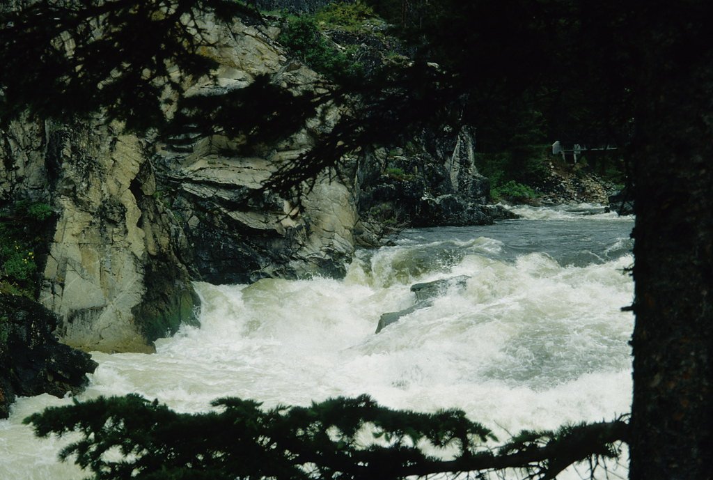
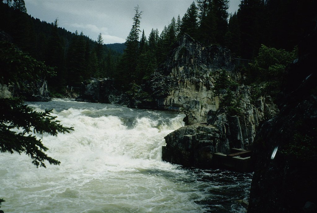
About Dagger Falls
Dagger Falls is a striking ribbon of white water set against the remote backdrop of the Frank Church–River of No Return Wilderness. Known for its rugged beauty and as a vantage point for salmon during migration season, the falls offer a rewarding glimpse of Idaho’s wild waterways. Visitors often come for the scenery and wildlife, then linger to soak up the canyon atmosphere. The falls and access routes are managed by the U.S. Forest Service within Boise National Forest. The most direct access is via the USFS Sulphur Creek Cutoff (Trail #4215); nearby Boundary Creek Campground sits just 0.6 km away for convenient car camping and basecamping options. Whether you’re out for a short viewpoint stop or pairing the visit with an overnight at Boundary Creek, Dagger Falls is an inviting destination for moderate hikers and nature lovers.
The Setting
Dagger Falls sits at 5,676 feet within Boise National Forest, fed by the Mf Salmon River, in the high mountains of Idaho.
Trail & Hike Details
The Approach
The moderate hike follows Sulphur Creek Cutoff (#4215), a 2.4-mile out-and-back trail over natural surface. Expect 350 feet of elevation gain. The trail is moderately developed (Class 2).
USFS Trail
SULPHUR CREEK CUTOFF #4215
Trail Class
Moderately Developed
Surface
USFS Segment
2.99 miTrail Description
The established approach to Dagger Falls follows the U.S. Forest Service Sulphur Creek Cutoff (Trail #4215), an out-and-back route listed with a GIS length of 2.99 miles and commonly reported as a 2.4-mile hike each way. Expect about 350 feet of elevation gain and a moderate overall difficulty. The trail is Class 2 and uses native material for its surface, so you’ll encounter a mostly natural tread with some uneven or rocky sections; it’s suitable for hikers comfortable with moderate footing. The path leads to a viewing platform overlooking the falls, and is maintained for general public access. Trail type: out-and-back. Surface: native material. Class: 2. Length (USFS GIS): 2.99 miles (commonly hiked as ~2.4 miles). Elevation gain: 350 ft. Difficulty: moderate. Nearest campground: Boundary Creek Campground — 0.6 km away.
What to Expect
Dogs are welcome.
Accessibility
The trail is not wheelchair accessible. Uneven terrain and elevation changes require steady footing.
Frequently Asked Questions
🐶 Are Dogs Allowed at Dagger Falls?
✅ Dogs are allowed
Are There Any Fees or Permits Required?
🆖 No fees required
🏊 Is There Swimming at Dagger Falls?
❌ Swimming is not allowed
When to Visit
Late spring to early summer is the best time to visit, as the water flow is strongest and salmon migration is most active.
Seasonal Access
The best time to visit is Spring, Summer, and Fall. Access roads and trails may close during winter due to snow. Check with Boise National Forest for seasonal road closures.
Safety Information
The road to Dagger Falls can be rough and may require a high-clearance vehicle. Be cautious of wildlife and strong river currents. Always stay on designated trails and viewing platforms.
Current Water Conditions
Based on a USGS gauge 18.8 miles away
916 ft³/s
Current discharge — how much water is flowing
About average for this time of year
Based on 36 years of record
2.00 ft
Water depth at gauge
7-Day Discharge Trend
What does this mean for your visit?
Flow is about average for this time of year.
About This Gauge
This gauge is on a regional waterway. Conditions at the falls may differ, especially after local rain.
7-Day Flow Outlook
Based on the USGS gauge MF SALMON RIVER AT MF LODGE NR YELLOW PINE ID (30 km away).
Today
Barely Flowing
916 cfs
5/10Tomorrow
Barely Flowing
906 cfs
5/10Tue
Barely Flowing
885 cfs
5/10Wed
Barely Flowing
866 cfs
5/10Thu
Barely Flowing
855 cfs
5/10Fri
Barely Flowing
842 cfs
5/10Sat
Barely Flowing
832 cfs
5/10Best window: Today — barely flowing flow, sunny (trip score 5/10).
Best time of year: this gauge typically runs highest from mid April to mid July, peaking in May.
How we calculate this
This is a transparent outlook, not a precise forecast. We take the waterfall's current flow strength (how it ranks against its historical normal for today, from the nearest USGS stream gauge), carry that ranking forward along the gauge's seasonal curve, and nudge it for forecast rain. Confidence is highest for the next day or two and falls further out. Always check official conditions and your own judgment before visiting — high flows can be dangerous.
Know when to go.
Get a free email alert when waterfalls near Yellow Pine hit peak flow. We only send when conditions are worth the trip — no weekly newsletters, no spam.
Weather Forecast
Location & Access
Getting There
Dagger Falls is accessible via Forest Road 579, also known as the Boundary Creek Road. The road can be rough and may require a high-clearance vehicle, especially in wet conditions. It is located approximately 25 miles from Stanley, Idaho.
Get Directions on Google MapsParking
There is a small parking area near the falls, which also serves as a trailhead for the Middle Fork of the Salmon River.
Elevation
5,676 feet above sea level
Coordinates
44.529626° N, -115.285939° W
Land Management
Managed by USFS
Visitor Tips & Gear
Visit in late spring or early summer for the best water flow and to see salmon. Bring a camera to capture the scenic beauty. Be prepared for rough roads leading to the falls.
This trail sits at 5,676 ft above sea level
Elevated TrailUV radiation is roughly 23% stronger at this elevation than at sea level, and the dry air accelerates dehydration. Extra sun protection and fluids go a long way.
As an Amazon Associate, we earn from qualifying purchases.

Coppertone Sport SPF 50 Sunscreen
UV intensity jumps ~4% per 1,000 ft — at this elevation you can burn in half the time.

Sun Bum SPF 30 Lip Balm (3-Pack)
Lips have almost no natural UV protection and burn fast in thin, dry mountain air.

Liquid I.V. Electrolyte Packets
You lose moisture ~2x faster at elevation — electrolytes help you absorb water efficiently.

ROCKNIGHT Polarized UV400 Sunglasses
High-altitude glare off rock and water is intense — UV400 lenses block 99%+ of UVA/UVB.
As an Amazon Associate, we earn from qualifying purchases.
With 2.4 miles and 350 ft of elevation gain, sturdy boots and trekking poles will help on this moderate trail. Sun exposure on the trail makes good sun protection a must in summer.

Polarized Sunglasses (Knockaround)
Cuts glare off the water so you actually see the falls — and your photos turn out better too.

Columbia Watertight II Rain Jacket
Packs into its own pocket, seam-sealed, and keeps you dry from spray and surprise rain.

Earth Pak Waterproof Dry Bag
Keeps your phone and gear dry when waterfall mist soaks everything else.

Waterproof Phone Pouch (AiRunTech)
Cheap insurance — take photos right next to the falls without killing your phone.

Timberland Euro Sprint Mid Waterproof
Trusted waterproof boot with premium leather and grippy rubber sole — reliable on rocky, wet trails.

TrailBuddy Trekking Poles
Lightweight aluminum, cork grips, and flip-locks that actually hold — a best-seller for good reason.
Where to Stay

Browse vacation cabins and private rentals nearby
Unique outdoor stays — tents, yurts, and treehouses
Rent a campervan or RV for your waterfall road trip
Some links are affiliate links. We may earn a commission at no extra cost to you.
Nearby Campground
BOUNDARY CREEK CAMPGROUND
0.4 miles away · 5 sites
Overview Boundary Creek Campground is located at the edge of the Frank Church River of No Return Wilderness, adjacent to the boat launch for the Middle Fork of the Salmon River in Idaho. The site generally provides overnight camping for boaters waiting to launch the next day on their permit to float the Middle Fork. Of the 15 campsites, 5 can be reserved during the high-use season (June 15-Aug. 15); the remaining 10 are first-come, first-served. Outside of those dates, all 15 sites are first-come
Book on Recreation.govNearby Hot Springs
Hot springs near Yellow Pine, Idaho
Dagger Creek Hot Spring
Dagger Creek Hot Spring reaches 110 degrees Fahrenheit at 5,740 feet in the Boise National Forest, sitting less than a mile fro...
Sulphur Creek Hot Spring
Sulphur Creek Hot Spring sits just 2.6 kilometers from Boundary Creek Campground at the gateway to the Frank Church River of No...
Bear Valley Hot Spring
Bear Valley Hot Spring hides at 6,210 feet in the Boise National Forest, requiring a 2.5-mile hike to reach. Recent USGS measur...
Sheepeater Hot Springs
Sheepeater Hot Springs requires a 4.2-mile hike through the Boise National Forest near Cascade, reaching thermal water at 5,115...
Sulphur Creek Hot Spring
Sulphur Creek Hot Spring in Custer County requires a genuine hike of over 1.3 miles through the Challis National Forest to reac...
Cape Horn Warm Springs
Cape Horn Warm Springs sits at 6,555 feet in Boise County, one of the higher thermal features near Idaho City, producing 95-deg...
Looking for a soak after your hike? Explore more hot springs near Yellow Pine, Idaho on SoakingSprings.
Explore Idaho springsAdditional Information
Nearby Attractions
Boundary Creek Campground, Middle Fork of the Salmon River, Frank Church-River of No Return Wilderness.
Wildlife
Visitors may see salmon, deer, elk, and a variety of birds. Bears are also present in the area, so proper precautions should be taken.
Cities near Dagger Falls
Nearby Waterfalls
Writing about Dagger Falls? Embed this waterfall on your site for free.