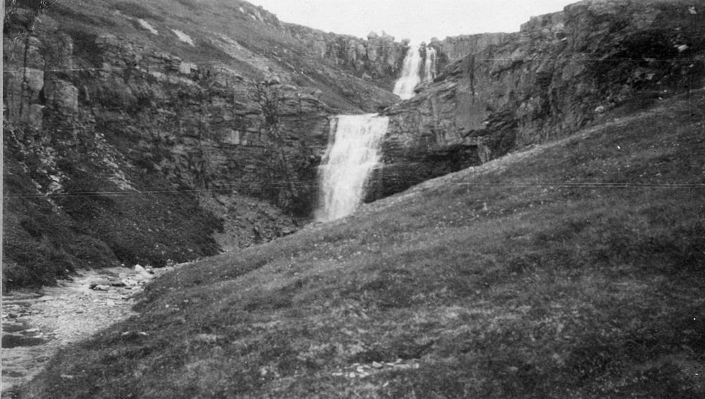
Crooked Creek Falls
By Armen Suny · Last verified May 2026
Photo Credits (1)
Difficulty
Moderate
Trail Length
2.0 miles
Trail Type
Out And Back
Elevation Gain
300 ft
About Crooked Creek Falls
Crooked Creek Falls is a quiet, picture-perfect cascade tucked into the forested hills of the Yakama Nation Reservation. This lesser-known gem offers a peaceful retreat amid mossy rocks and lush green canopy, and sits on land owned by DESG and managed by tribal authorities (designation: TRIB). The setting feels intimate and wooded, making it a great short escape for hikers who prefer a more secluded waterfall experience. Access to the falls is via a relatively short hike — the route is an out-and-back of about 2.0 miles with roughly 300 feet of elevation gain. The trail is rated moderate and rewards visitors with close-up views of the falls after a steady, forested climb. Because the path travels through uneven terrain and root-strewn sections, come prepared with good footwear and a day-hike mindset rather than expecting developed campground facilities nearby.
The Setting
Crooked Creek Falls sits at 6,145 feet within Yakama Nation Reservation, fed by the Klickitat River, in the high mountains of Washington.
Trail & Hike Details
The Approach
The moderate 2.0-mile out-and-back trail gains 300 feet of elevation on the way to the falls.
Trail Description
Trail length: ~2.0 miles (out-and-back); elevation gain: ~300 feet; difficulty: moderate. The trail follows a single forested path that climbs steadily to the falls. Surface conditions are natural — packed dirt with exposed roots, rocks, and occasional uneven footing — so expect a moderate grade in sections and bring sturdy shoes. The route is a classic short day-hike rather than a developed, paved route; watch your step on wet or mossy portions of the trail.
What to Expect
Dogs are welcome.
Accessibility
The trail is not wheelchair accessible. Uneven terrain and elevation changes require steady footing.
Frequently Asked Questions
🐶 Are Dogs Allowed at Crooked Creek Falls?
✅ Dogs are allowed
Are There Any Fees or Permits Required?
🤑 Fee: $5.00
Permit required
A Northwest Forest Pass or equivalent is required for parking at the trailhead. Passes can be purchased online or at local vendors.
🏊 Is There Swimming at Crooked Creek Falls?
❌ Swimming is not allowed
When to Visit
Spring and early summer are ideal times to visit, as the waterfall flow is typically strongest due to snowmelt. Fall offers beautiful foliage, while summer provides warmer weather for hiking.
Seasonal Access
The best time to visit is Spring, Summer, and Fall. Access roads and trails may close during winter due to snow.
Safety Information
The trail may be slippery, especially after rain. Watch for loose rocks and roots. Carry a first aid kit and let someone know your plans before heading out. Be prepared for changing weather conditions.
Current Water Conditions
140 ft³/s
Current discharge — how much water is flowing
Much lower than usual for this time of year
Based on 67 years of record
7-Day Discharge Trend
What does this mean for your visit?
Flow is well below normal for this time of year, so the waterfall may be a trickle.
About This Gauge
This gauge is on a nearby waterway and may not reflect exact conditions at the falls.
7-Day Flow Outlook
Based on the USGS gauge KLICKITAT RIVER ABOVE WEST FORK NEAR GLENWOOD, WA (21 km away).
Today
Low
150 cfs
4/10Tomorrow
Low
154 cfs
4/10Sun
Low
152 cfs
4/10Mon
Low
145 cfs
4/10Tue
Low
139 cfs
4/10Wed
Low
123 cfs
6/10Thu
Low
122 cfs
4/10Best window: Wed — low flow, mostly sunny (trip score 6/10).
Best time of year: this gauge typically runs highest from early April to early July, peaking in May.
How we calculate this
This is a transparent outlook, not a precise forecast. We take the waterfall's current flow strength (how it ranks against its historical normal for today, from the nearest USGS stream gauge), carry that ranking forward along the gauge's seasonal curve, and nudge it for forecast rain. Confidence is highest for the next day or two and falls further out. Always check official conditions and your own judgment before visiting — high flows can be dangerous.
Know when to go.
Get a free email alert when waterfalls near Trout Lake hit peak flow. We only send when conditions are worth the trip — no weekly newsletters, no spam.
Weather Forecast
Location & Access
Getting There
Crooked Creek Falls is located within the Gifford Pinchot National Forest in Washington. Access typically involves driving on forest roads, which may be unpaved and require a high-clearance vehicle during certain seasons. Exact directions should be verified with local resources or maps.
Get Directions on Google MapsParking
Parking is available near the trailhead, but spaces may be limited. Visitors are advised to arrive early, especially during weekends or peak seasons.
Elevation
6,145 feet above sea level
Coordinates
46.147066° N, -121.454526° W
Land Management
Managed by TRIB
Visitor Tips & Gear
Bring plenty of water, wear sturdy hiking shoes, and check trail conditions before heading out. Cell service may be limited in the area, so download maps or directions in advance.
This trail sits at 6,145 ft above sea level
Elevated TrailUV radiation is roughly 25% stronger at this elevation than at sea level, and the dry air accelerates dehydration. Extra sun protection and fluids go a long way.
As an Amazon Associate, we earn from qualifying purchases.

Coppertone Sport SPF 50 Sunscreen
UV intensity jumps ~4% per 1,000 ft — at this elevation you can burn in half the time.

Sun Bum SPF 30 Lip Balm (3-Pack)
Lips have almost no natural UV protection and burn fast in thin, dry mountain air.

Liquid I.V. Electrolyte Packets
You lose moisture ~2x faster at elevation — electrolytes help you absorb water efficiently.

ROCKNIGHT Polarized UV400 Sunglasses
High-altitude glare off rock and water is intense — UV400 lenses block 99%+ of UVA/UVB.
As an Amazon Associate, we earn from qualifying purchases.
With 2.0 miles and 300 ft of elevation gain, sturdy boots and trekking poles will help on this moderate trail. Sun exposure on the trail makes good sun protection a must in summer.

Polarized Sunglasses (Knockaround)
Cuts glare off the water so you actually see the falls — and your photos turn out better too.

Columbia Watertight II Rain Jacket
Packs into its own pocket, seam-sealed, and keeps you dry from spray and surprise rain.

Earth Pak Waterproof Dry Bag
Keeps your phone and gear dry when waterfall mist soaks everything else.

Waterproof Phone Pouch (AiRunTech)
Cheap insurance — take photos right next to the falls without killing your phone.

Timberland Euro Sprint Mid Waterproof
Trusted waterproof boot with premium leather and grippy rubber sole — reliable on rocky, wet trails.

TrailBuddy Trekking Poles
Lightweight aluminum, cork grips, and flip-locks that actually hold — a best-seller for good reason.
Where to Stay

Browse vacation cabins and private rentals nearby
Unique outdoor stays — tents, yurts, and treehouses
Rent a campervan or RV for your waterfall road trip
Some links are affiliate links. We may earn a commission at no extra cost to you.
Nearby Campground
Takhlakh Lake Campground
11.5 miles away · 54 sites
Overview Takhlakh Lake Campground sits at an elevation of 4,400 feet in a well-shaded location next to its namesake lake. The campground sits at the base of Mt. Adams, providing visitors with incredible views in every direction. The campground has a short season, but it's a particularly popular destination for hikers exploring the trails around Mt. Adams. Recreation The campsite offers access to the Takhlakh Loop, an accessible trail suitable for all ages and skill levels and the Takhlakh Meadow
Book on Recreation.govNearby Hot Springs
Hot springs near Trout Lake, Washington

Mount Adams Fumaroles
Mount Adams fumaroles reach 150 degrees at 12,269 feet elevation, emerging 136 degrees above ambient on Washington's second-hig...
Orr Creek Warm Springs
Orr Creek Warm Springs emerges at 72 degrees in the Gifford Pinchot National Forest at 2,910 feet elevation, flowing 26.5 degre...
Fish Hatchery Warm Spring
Fish Hatchery Warm Spring produces 75-degree water on Yakama Nation Reservation lands, flowing 23.7 degrees above ambient tempe...
Klickitat Mineral Springs
Klickitat Mineral Springs produces 81-degree water at just 481 feet elevation on state conservation lands, flowing 27.9 degrees...
Packwood Hot Spring
Packwood Hot Spring flows at 100 degrees at 1,002 feet elevation in the lower Cascade foothills near Morton, emerging 49.8 degr...

Collins Hot Springs
Collins Hot Springs emerges at 122 degrees just 127 feet above sea level in the Columbia River Gorge, producing water 68.4 degr...
Looking for a soak after your hike? Explore more hot springs near Trout Lake, Washington on SoakingSprings.
Explore Washington springsAdditional Information
Nearby Attractions
Nearby attractions include other waterfalls in the Gifford Pinchot National Forest, such as Panther Creek Falls and Falls Creek Falls. Mount St. Helens is also within driving distance.
Wildlife
The area is home to a variety of wildlife, including deer, birds, and small mammals. Visitors should be cautious of bears and other larger animals, especially during dawn and dusk.
Cities near Crooked Creek Falls
Writing about Crooked Creek Falls? Embed this waterfall on your site for free.