
Photo Credits (1)
Difficulty
Moderate
Trail Length
2.4 miles
Trail Type
Out And Back
Elevation Gain
350 ft
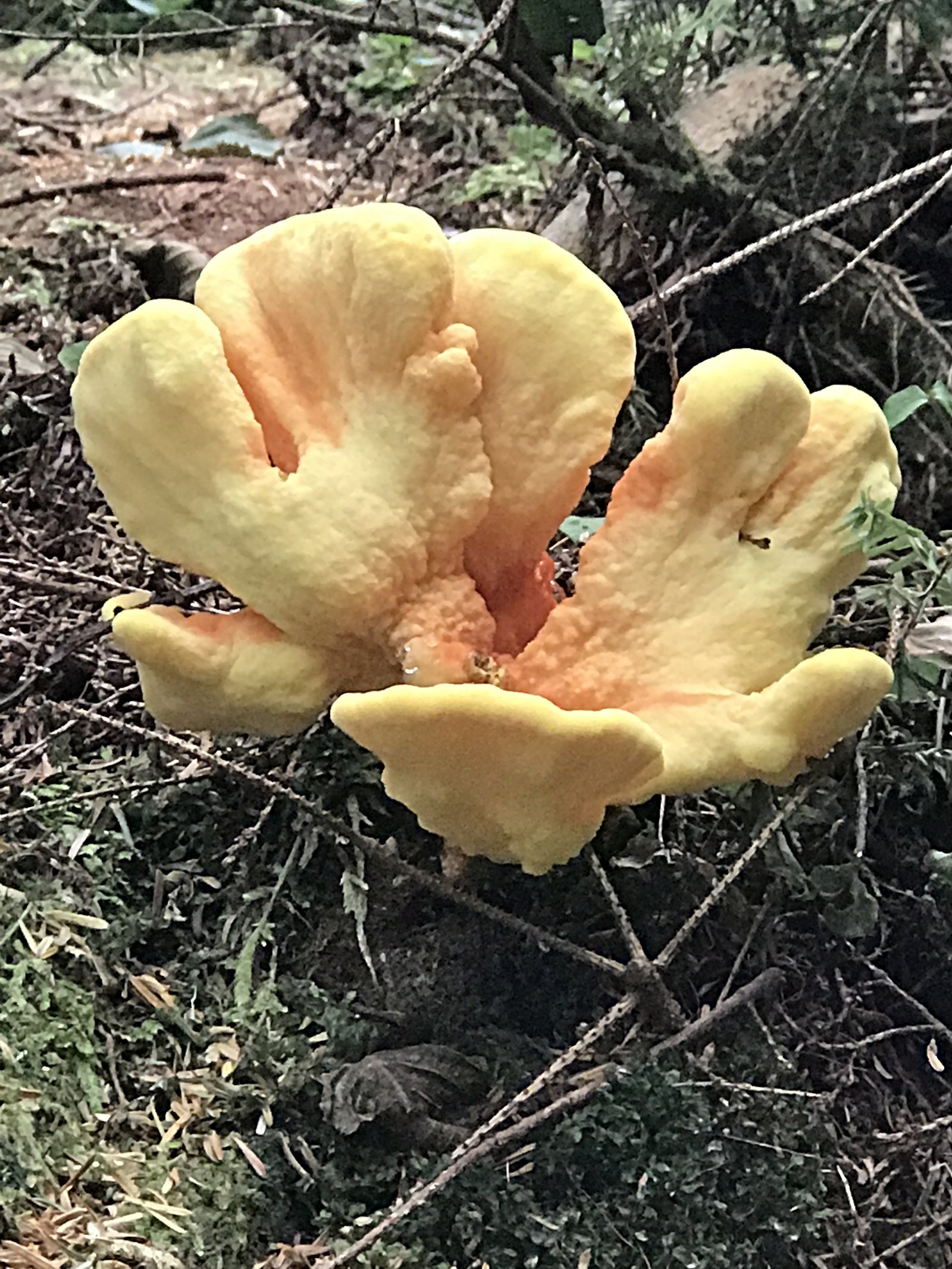
About Chitwood Falls
Chitwood Falls tumbles from Chitwood Creek just before the creek empties into the Cascade Head North Marine Protected Area, offering a tucked-away Pacific Northwest scene in Tillamook County. The falls and approach sit inside the Siuslaw National Forest and are managed by the U.S. Forest Service; access is from Forest Road 1861 and the common route is the Hart's Cove Trail (USFS #1303). The hike to the falls is a peaceful, moderately paced out-and-back that covers roughly 2.4 miles (USFS GIS lists 2.58 miles) with about 350 feet of elevation gain. The route threads through classic coastal-forest vegetation and is ideal for hikers looking for a short, scenic outing—bring a camera for creek and coastal-woodland views and be prepared for moderate grades on native tread.
The Setting
Chitwood Falls sits at 686 feet within Siuslaw National Forest, fed by the Nestucca River, in the foothills of Oregon.
Trail & Hike Details
The Approach
The moderate hike follows Hart's Cove (#1303), a 2.4-mile out-and-back trail over natural surface. Expect 350 feet of elevation gain with grades of 12-20%. The trail is developed (Class 3).
USFS Trail
HART'S COVE #1303
Trail Class
Developed
Surface
Avg Grade
USFS Segment
2.58 miTrail Description
Hart's Cove Trail (USFS #1303) — out-and-back approximately 2.4 miles (USFS GIS: 2.58 miles) with ~350 ft elevation gain; difficulty: moderate. Surface: NATIVE MATERIAL. Typical grade: 12–20%. Trail class: 3. Trailhead access is from Forest Road 1861; expect native-forest tread with steeper sections consistent with the listed grade.
What to Expect
Expect a quiet and scenic waterfall surrounded by dense forest. The area may be less developed, so amenities like restrooms or picnic areas are unlikely.
Accessibility
The trail is not wheelchair accessible. Uneven terrain and elevation changes require steady footing.
Frequently Asked Questions
🐶 Are Dogs Allowed at Chitwood Falls?
❌ Dogs are not allowed
Are There Any Fees or Permits Required?
🆖 No fees required
🏊 Is There Swimming at Chitwood Falls?
❌ Swimming is not allowed
When to Visit
Spring and early summer are ideal for visiting, as the waterfall is likely to have the most water flow during these seasons.
Seasonal Access
The best time to visit is Spring, Summer, Fall, and Winter. Check with Siuslaw National Forest for seasonal road closures.
Safety Information
Trails may be slippery or uneven, especially after rain. Visitors should exercise caution near the waterfall and avoid climbing on wet rocks.
Current Water Conditions
Based on a USGS gauge 15.1 miles away
180 ft³/s
Current discharge — how much water is flowing
About average for this time of year
Based on 41 years of record
4.44 ft
Water depth at gauge
62°F
CoolRefreshing for swimming
7-Day Discharge Trend
What does this mean for your visit?
Flow is about average for this time of year. Water temperature is a refreshing 62 degrees F, good for a quick swim.
About This Gauge
This gauge is on a regional waterway. Conditions at the falls may differ, especially after local rain.
7-Day Flow Outlook
Based on the USGS gauge NESTUCCA RIVER NEAR BEAVER, OR (24 km away).
Today
Low
194 cfs
4/10Tomorrow
Low
200 cfs
4/10Sun
Low
194 cfs
4/10Mon
Low
183 cfs
4/10Tue
Low
180 cfs
4/10Wed
Low
177 cfs
4/10Thu
Low
180 cfs
4/10Best window: Today — low flow, rain showers (trip score 4/10).
Best time of year: this gauge typically runs highest from mid December to early January, peaking in January.
How we calculate this
This is a transparent outlook, not a precise forecast. We take the waterfall's current flow strength (how it ranks against its historical normal for today, from the nearest USGS stream gauge), carry that ranking forward along the gauge's seasonal curve, and nudge it for forecast rain. Confidence is highest for the next day or two and falls further out. Always check official conditions and your own judgment before visiting — high flows can be dangerous.
Know when to go.
Get a free email alert when waterfalls near Neskowin hit peak flow. We only send when conditions are worth the trip — no weekly newsletters, no spam.
Weather Forecast
Location & Access
Getting There
Chitwood Falls is located near the small community of Chitwood, Oregon. Access details are limited, but it is typically reached via local roads. Visitors should research specific directions before traveling.
Get Directions on Google MapsParking
Parking availability is unclear. Visitors may need to park along nearby roads or in designated areas if available.
Elevation
686 feet above sea level
Coordinates
45.073995° N, -123.993726° W
Land Management
Managed by USFS
Visitor Tips & Gear
Bring sturdy footwear, as trails may be uneven or muddy. Check weather conditions before visiting, and carry a map or GPS device as signage may be limited.
As an Amazon Associate, we earn from qualifying purchases.
With 2.4 miles and 350 ft of elevation gain, sturdy boots and trekking poles will help on this moderate trail. Icy conditions are common in winter — traction cleats are a smart addition.

Columbia Watertight II Rain Jacket
Packs into its own pocket, seam-sealed, and keeps you dry from spray and surprise rain.

Polarized Sunglasses (Knockaround)
Cuts glare off the water so you actually see the falls — and your photos turn out better too.

Earth Pak Waterproof Dry Bag
Keeps your phone and gear dry when waterfall mist soaks everything else.

Waterproof Phone Pouch (AiRunTech)
Cheap insurance — take photos right next to the falls without killing your phone.

Timberland Euro Sprint Mid Waterproof
Trusted waterproof boot with premium leather and grippy rubber sole — reliable on rocky, wet trails.

TrailBuddy Trekking Poles
Lightweight aluminum, cork grips, and flip-locks that actually hold — a best-seller for good reason.
Where to Stay

Neskowin Nirvana

Cozy Coastal Condo Steps from the Beach with Deck Views

Surfland Hotel

Proposal Rock View
Browse vacation cabins and private rentals nearby
Unique outdoor stays — tents, yurts, and treehouses
Rent a campervan or RV for your waterfall road trip
Some links are affiliate links. We may earn a commission at no extra cost to you.
Nearby Campground
Tillamook to Newport
9.4 miles away · 0 sites
A visitor to the Siuslaw National Forest traveling from Tillamook to Newport will find farmland, rolling hills, sand dunes at Sand Lake Recreation Area, and by choosing the Three Cape Scenic Loop, gorgeous headlands with fantastic views of the Pacific Ocean.Moving inland, the Forest is lush, wet and green. Visitors can hike, camp, picnic or ride their off-highway vehicle. Highway 101, the Pacific Coast Scenic Byway, transports travelers from Tillamook to Newport with connecting routes of Highway
Book on Recreation.govAdditional Information
Nearby Attractions
The historic Chitwood Covered Bridge is a notable nearby attraction.
Wildlife
The area may feature typical Pacific Northwest wildlife such as birds, deer, and small mammals.
Cities near Chitwood Falls
Writing about Chitwood Falls? Embed this waterfall on your site for free.