
Difficulty
Moderate
Trail Length
2.4 miles
Trail Type
Out And Back
Elevation Gain
350 ft
About Chain of Rocks
Chain of Rocks is a unique feature located on the Mississippi River near St. Louis, Missouri. It is not a traditional waterfall but rather a natural rock formation that creates a series of rapids and small cascades across the river. The area is known for its historical significance and the nearby Chain of Rocks Bridge, which is a popular spot for walking and cycling.
The Setting
Chain of Rocks sits at 400 feet along the Maline Creek, in the coastal lowlands of Missouri.
Trail & Hike Details
The Approach
The moderate 2.4-mile out-and-back trail gains 350 feet of elevation on the way to the falls.
Trail Description
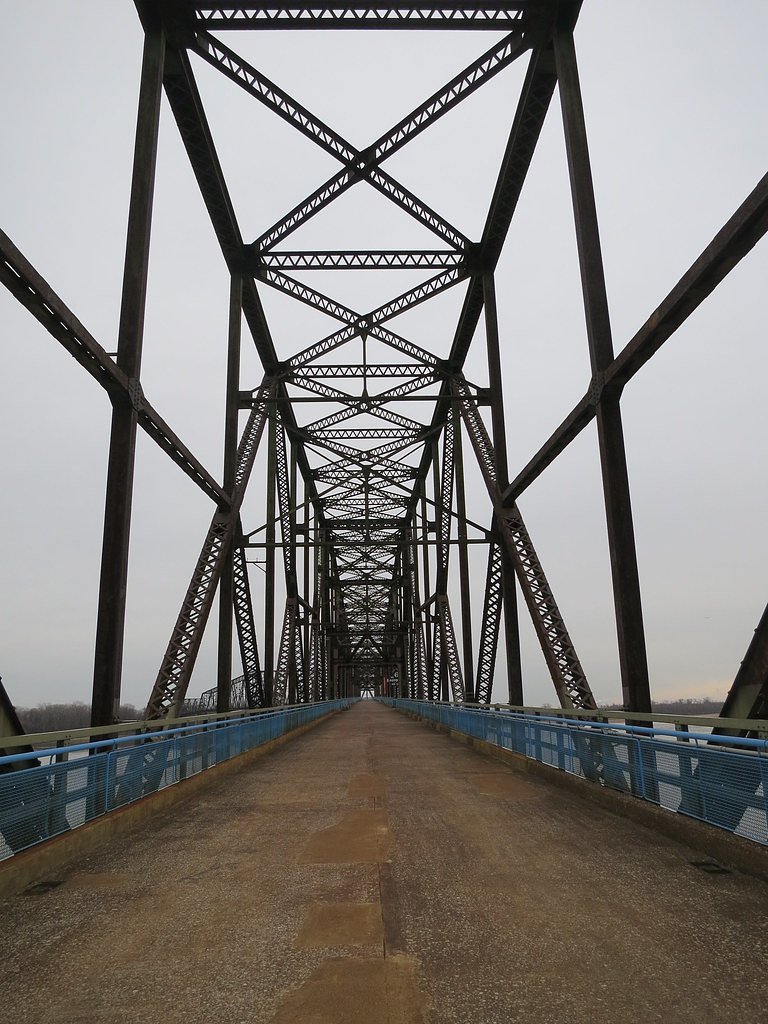
The trail across the Chain of Rocks Bridge is a flat, paved path that offers stunning views of the Mississippi River and the Chain of Rocks formation. It is suitable for walking, cycling, and wheelchair users. The bridge itself is a historic landmark and provides a unique vantage point for observing the river and surrounding area.
What to Expect
Dogs are welcome.
Accessibility
The trail is not wheelchair accessible. Uneven terrain and elevation changes require steady footing.
Frequently Asked Questions
🐶 Are Dogs Allowed at Chain of Rocks?
✅ Dogs are allowed
Are There Any Fees or Permits Required?
🆖 No fees required
🏊 Is There Swimming at Chain of Rocks?
❌ Swimming is not allowed
When to Visit
The Chain of Rocks is accessible year-round, but spring and fall are particularly pleasant due to milder weather and vibrant scenery.
Seasonal Access
The best time to visit is Spring, Summer, Fall, and Winter.
Safety Information
Be cautious of strong winds on the bridge and avoid leaning over railings. Do not attempt to swim in the river due to dangerous currents. Stay on designated paths and avoid venturing onto the rocks.
Current Water Conditions
23 ft³/s
Current discharge — how much water is flowing
About average for this time of year
Based on 29 years of record
2.58 ft
Water depth at gauge
7-Day Discharge Trend
What does this mean for your visit?
Flow is about average for this time of year.
About This Gauge
7-Day Flow Outlook
Based on the USGS gauge Maline Creek at Bellefontaine Neighbors, MO (5 km away).
Today
Strong
26 cfs
7/10Tomorrow
Strong
33 cfs
7/10Mon
Moderate
21 cfs
9/10Tue
Moderate
20 cfs
9/10Wed
Moderate
22 cfs
9/10Thu
Moderate
18 cfs
9/10Fri
Strong
23 cfs
7/10Best window: Mon — moderate flow, sunny (trip score 9/10).
Best time of year: this gauge typically runs highest from late March to early May, peaking in March.
How we calculate this
This is a transparent outlook, not a precise forecast. We take the waterfall's current flow strength (how it ranks against its historical normal for today, from the nearest USGS stream gauge), carry that ranking forward along the gauge's seasonal curve, and nudge it for forecast rain. Confidence is highest for the next day or two and falls further out. Always check official conditions and your own judgment before visiting — high flows can be dangerous.
Know when to go.
Get a free email alert when waterfalls near Glasgow Village hit peak flow. We only send when conditions are worth the trip — no weekly newsletters, no spam.
Weather Forecast
Location & Access
Getting There
Chain of Rocks can be accessed via the Chain of Rocks Bridge, which is located off Riverview Drive in St. Louis, Missouri. The bridge is part of the Route 66 Bikeway and is pedestrian-friendly.
Get Directions on Google MapsParking
Parking is available near the Chain of Rocks Bridge on both the Missouri and Illinois sides. Visitors should check for any posted signs or restrictions.
Elevation
400 feet above sea level
Coordinates
38.759167° N, -90.179167° W
Visitor Tips & Gear
Wear comfortable shoes for walking and bring water, especially during warmer months. The bridge can be windy, so dress appropriately. Be cautious of cyclists sharing the path. Check for any closures or restrictions before visiting.
As an Amazon Associate, we earn from qualifying purchases.
With 2.4 miles and 350 ft of elevation gain, sturdy boots and trekking poles will help on this moderate trail. Icy conditions are common in winter — traction cleats are a smart addition.

Columbia Watertight II Rain Jacket
Packs into its own pocket, seam-sealed, and keeps you dry from spray and surprise rain.

Polarized Sunglasses (Knockaround)
Cuts glare off the water so you actually see the falls — and your photos turn out better too.

Earth Pak Waterproof Dry Bag
Keeps your phone and gear dry when waterfall mist soaks everything else.

Waterproof Phone Pouch (AiRunTech)
Cheap insurance — take photos right next to the falls without killing your phone.

Timberland Euro Sprint Mid Waterproof
Trusted waterproof boot with premium leather and grippy rubber sole — reliable on rocky, wet trails.

TrailBuddy Trekking Poles
Lightweight aluminum, cork grips, and flip-locks that actually hold — a best-seller for good reason.
Where to Stay

WhiteHouse at Grand Central

BEL AIR MOTEL

Best Western Plus Parkway Hotel

Pear Tree Inn St. Louis Airport
Browse vacation cabins and private rentals nearby
Unique outdoor stays — tents, yurts, and treehouses
Rent a campervan or RV for your waterfall road trip
Some links are affiliate links. We may earn a commission at no extra cost to you.
Additional Information
Nearby Attractions
Nearby attractions include the Gateway Arch in downtown St. Louis, the Missouri Botanical Garden, and Cahokia Mounds State Historic Site in Illinois.
Wildlife
The area is home to various bird species, including herons and eagles, as well as other river wildlife. Visitors may also spot fish in the river below.
Cities near Chain of Rocks
Writing about Chain of Rocks? Embed this waterfall on your site for free.