Cedar Falls
Illinois • 80 ft
By Armen Suny · Last verified Mar 2026
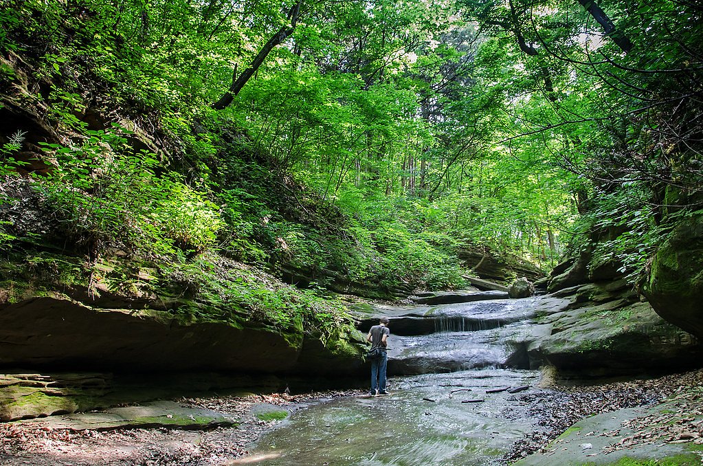


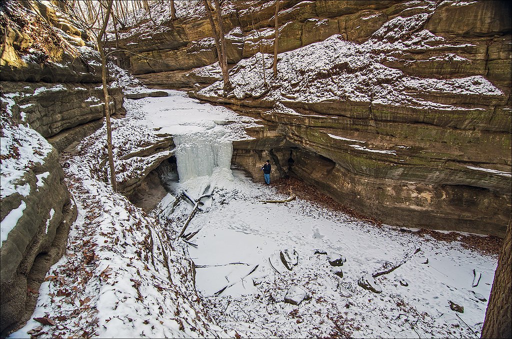
Photo Credits (5)
Difficulty
Moderate
Trail Length
1.7 miles
Trail Type
Out And Back
Elevation Gain
200 ft
About Cedar Falls
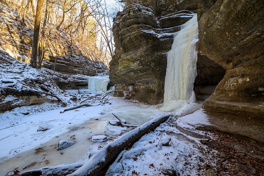
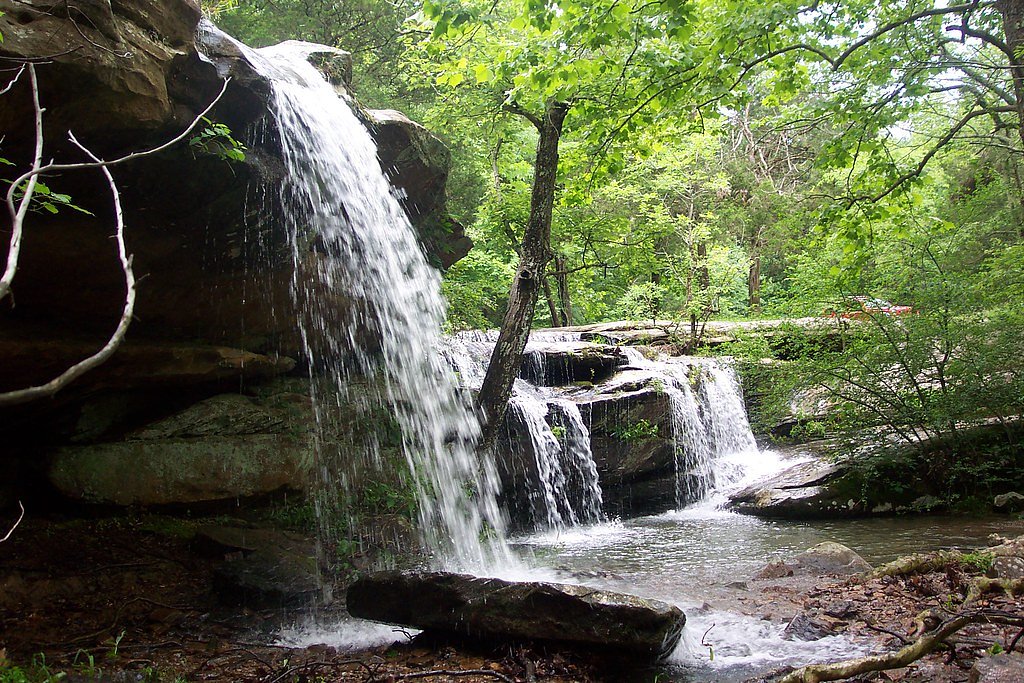
Cedar Falls tumbles roughly 80 feet into a narrow sandstone canyon tucked within Shawnee National Forest, making it one of Illinois’ taller and more dramatic cascades. The falls are especially striking after periods of heavy rain, framed by steep rock and mixed hardwoods that make the runout below the drop a scenic spot for photos and a short rest. While multiple places share the name “Cedar Falls,” this entry refers to the waterfall reached from the forest trail in southern Illinois. The waterfall is reached by a relatively short, moderately rated hike: an out-and-back route of about 1.7 miles with roughly 200 feet of elevation change. The approach winds through forest and descends into the canyon, so expect rocky, uneven footing in places. The nearest developed camping is at the Hidden Springs Ranger District, approximately 17.4 km (about 10.8 miles) away, so overnight options are not immediately adjacent to the trailhead; plan accordingly.
The Setting
Cedar Falls sits at 436 feet along the South Fork Saline River, in the coastal lowlands of Illinois. The falls drop 80 feet.
Height: 80 feet
Trail & Hike Details
The Approach
The moderate 1.7-mile out-and-back trail gains 200 feet of elevation on the way to the falls.
Trail Description
Out-and-back trail, approximately 1.7 miles total with about 200 feet of elevation gain (moderate difficulty). The route follows a forest path that becomes rocky and uneven in sections as it descends into the canyon; there are short steeper segments near the approach to the falls. The trail ends at the overlook/stream access for the roughly 80-foot Cedar Falls. Specific USFS trail surface/grade/class identifiers are not provided in the available data.
What to Expect
The falls cascade 80 feet. Dogs are welcome.
Accessibility
The trail is not wheelchair accessible. Uneven terrain and elevation changes require steady footing.
Frequently Asked Questions
🐶 Are Dogs Allowed at Cedar Falls?
✅ Dogs are allowed
Are There Any Fees or Permits Required?
🆖 No fees required
🏊 Is There Swimming at Cedar Falls?
❌ Swimming is not allowed
When to Visit
Spring and after heavy rainfall are the best times to visit Cedar Falls, as the waterfall flow is strongest during these periods.
Seasonal Access
The best time to visit is Spring, Summer, Fall, and Winter.
Safety Information
The trail can be slippery after rain, and there are steep sections near the canyon. Visitors should exercise caution and stay on marked trails. Carry a map or GPS device, as cell service may be limited.
Current Water Conditions
58 ft³/s
Current discharge — how much water is flowing
Higher than usual for this time of year
Based on 60 years of record
2.97 ft
Water depth at gauge
7-Day Discharge Trend
What does this mean for your visit?
The water is flowing higher than usual for this time of year.
About This Gauge
This gauge is on a nearby waterway and may not reflect exact conditions at the falls.
7-Day Flow Outlook
Based on the USGS gauge SOUTH FORK SALINE RIVER NR CARRIER MILLS, IL (14 km away).
Today
Moderate
58 cfs
8/10Tomorrow
Moderate
65 cfs
8/10Fri
Moderate
70 cfs
6/10Sat
Moderate
70 cfs
6/10Sun
Moderate
70 cfs
6/10Mon
Moderate
74 cfs
6/10Tue
Moderate
70 cfs
6/10Best window: Today — moderate flow, sunny (trip score 8/10).
Best time of year: this gauge typically runs highest from mid February to early May, peaking in March.
How we calculate this
This is a transparent outlook, not a precise forecast. We take the waterfall's current flow strength (how it ranks against its historical normal for today, from the nearest USGS stream gauge), carry that ranking forward along the gauge's seasonal curve, and nudge it for forecast rain. Confidence is highest for the next day or two and falls further out. Always check official conditions and your own judgment before visiting — high flows can be dangerous.
Know when to go.
Get a free email alert when waterfalls near Simpson hit peak flow. We only send when conditions are worth the trip — no weekly newsletters, no spam.
Weather Forecast
Location & Access
Getting There
Cedar Falls is located within the Shawnee National Forest near the Giant City State Park area. Visitors can access the trailhead from Giant City Road, with clear signage leading to the waterfall.
Get Directions on Google MapsParking
There is a designated parking area near the trailhead, which is typically free of charge. However, parking may be limited during peak seasons.
Elevation
436 feet above sea level
Coordinates
37.518106° N, -88.738392° W
Visitor Tips & Gear
Wear sturdy hiking shoes, especially after rain, as the trail can be slippery. Bring water and snacks, and consider visiting early in the day to avoid crowds. Check the weather forecast before your visit, as the waterfall flow depends on recent rainfall.
As an Amazon Associate, we earn from qualifying purchases.
With 1.7 miles and 200 ft of elevation gain, sturdy boots and trekking poles will help on this moderate trail. Icy conditions are common in winter — traction cleats are a smart addition.

Columbia Watertight II Rain Jacket
Packs into its own pocket, seam-sealed, and keeps you dry from spray and surprise rain.

Polarized Sunglasses (Knockaround)
Cuts glare off the water so you actually see the falls — and your photos turn out better too.

Earth Pak Waterproof Dry Bag
Keeps your phone and gear dry when waterfall mist soaks everything else.

Waterproof Phone Pouch (AiRunTech)
Cheap insurance — take photos right next to the falls without killing your phone.

Timberland Euro Sprint Mid Waterproof
Trusted waterproof boot with premium leather and grippy rubber sole — reliable on rocky, wet trails.

TrailBuddy Trekking Poles
Lightweight aluminum, cork grips, and flip-locks that actually hold — a best-seller for good reason.
Where to Stay

Carlton Cabin at Lake of Egypt 500 Sq Ft

Peaceful Custom Carbondale Home w/ Deck, Near SIU!

Drury Inn & Suites Marion

Pondview Escape a 75-Acre Retreat
Browse vacation cabins and private rentals nearby
Unique outdoor stays — tents, yurts, and treehouses
Rent a campervan or RV for your waterfall road trip
Some links are affiliate links. We may earn a commission at no extra cost to you.
Nearby Campground
Hidden Springs Ranger District
10.8 miles away · 0 sites
East side of the Shawnee National Forest
Book on Recreation.govAdditional Information
Nearby Attractions
Nearby attractions include Giant City State Park, Garden of the Gods, and Little Grand Canyon, all offering additional hiking and scenic views.
Wildlife
The area is home to a variety of wildlife, including deer, birds, and small mammals. Visitors may also encounter reptiles and amphibians near the water.
Cities near Cedar Falls
Nearby Waterfalls
Other waterfalls named Cedar Falls
8 other waterfalls share this name across the U.S.
Writing about Cedar Falls? Embed this waterfall on your site for free.