Photo Credits (5)
Difficulty
Moderate
Trail Length
3.0 miles
Trail Type
Out And Back
Elevation Gain
500 ft
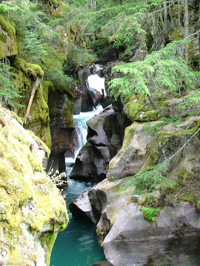
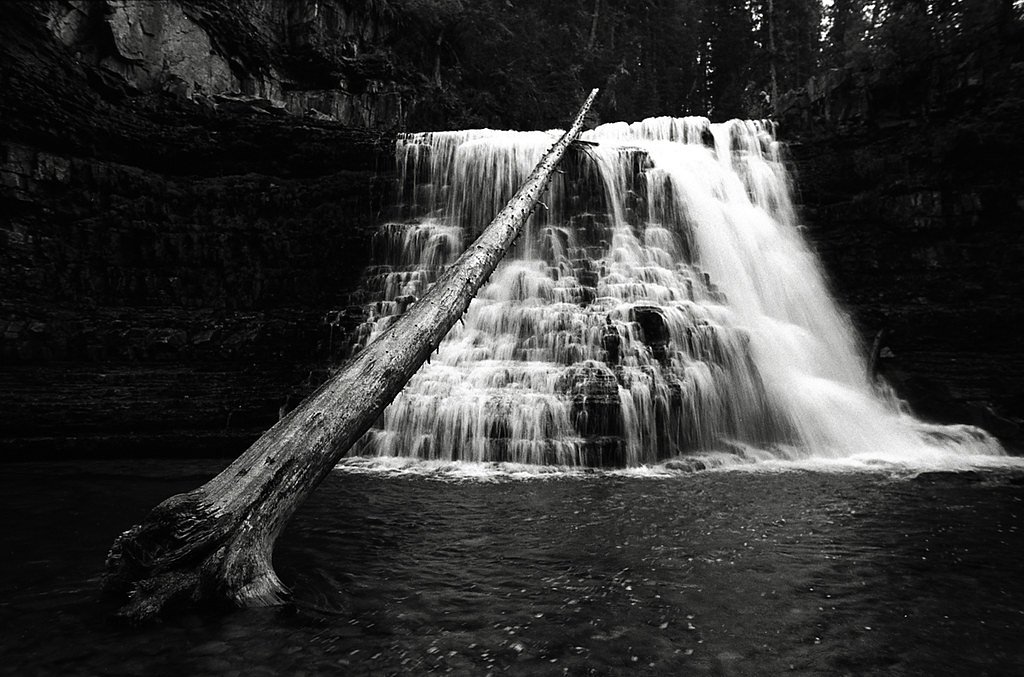
About Cedar Falls
Cedar Falls is a peaceful, picture-postcard cascade tucked into the forests of Lewis and Clark National Forest in Montana. The falls are framed by dense conifers and a lush understory, making the short outing feel secluded and verdant — a great spot for hikers who want the sound of rushing water without a long backcountry trek. Note that "Cedar Falls" is a common place name (Wikipedia notes multiple sites share it), so double-check local maps or the forest office to be sure you’re headed to the Montana cascade in Lewis and Clark NF. The route is popular with day-hikers and nature lovers, and if you’re planning to camp nearby, Bear Creek Cabin in Beaverhead–Deerlodge National Forest is about 9.6 km from the trailhead and offers a convenient overnight option. The setting feels quintessentially Northern Rockies: shaded trails, mossy rocks, and the steady rhythm of falling water.
The Setting
Cedar Falls sits at 9,311 feet along the Madison River, in the high alpine of Montana.
Trail & Hike Details
The Approach
The moderate 3.0-mile out-and-back trail gains 500 feet of elevation on the way to the falls.
Trail Description
This is a 3.0-mile out-and-back trail with roughly 500 feet of elevation gain; the route is rated moderate in difficulty. The tread winds through dense forest and is generally well-marked, but expect some rocky or uneven sections underfoot as you gain elevation toward the falls. Trail type: out-and-back. Difficulty: moderate. Distance: 3.0 miles. Elevation gain: ~500 ft. The path’s grade is steady rather than steep, making it a satisfying half-day hike for most experienced walkers; always check current trail conditions with the Lewis and Clark National Forest office before heading out.
What to Expect
Dogs are welcome.
Accessibility
The trail is not wheelchair accessible. Uneven terrain and elevation changes require steady footing.
Frequently Asked Questions
🐶 Are Dogs Allowed at Cedar Falls?
✅ Dogs are allowed
Are There Any Fees or Permits Required?
🆖 No fees required
🏊 Is There Swimming at Cedar Falls?
❌ Swimming is not allowed
When to Visit
The best time to visit Cedar Falls is during late spring or early summer when the water flow is at its peak due to snowmelt. Fall is also a great time to visit for cooler temperatures and vibrant foliage.
Seasonal Access
The best time to visit is Spring, Summer, and Fall. Access roads and trails may close during winter due to snow.
Safety Information
Hikers should be cautious of slippery rocks near the falls and watch for wildlife. Carry bear spray and know how to use it. Check trail conditions before heading out, especially during winter or after heavy rain.
Current Water Conditions
1,140 ft³/s
Current discharge — how much water is flowing
Lower than usual for this time of year
Based on 29 years of record
2.34 ft
Water depth at gauge
61°F
CoolRefreshing for swimming
7-Day Discharge Trend
What does this mean for your visit?
Flow is lower than usual for this time of year. Water temperature is a refreshing 61 degrees F, good for a quick swim. Expect excellent dissolved oxygen levels.
Water Quality
Dissolved Oxygen
ExcellentSupports aquatic life
About This Gauge
This gauge is on a nearby waterway and may not reflect exact conditions at the falls.
7-Day Flow Outlook
Based on the USGS gauge Madison River near Cameron MT (18 km away).
Today
Moderate
1300 cfs
4/10Tomorrow
Moderate
1354 cfs
5/10Sun
Moderate
1340 cfs
5/10Mon
Moderate
1298 cfs
5/10Tue
Moderate
1338 cfs
6/10Wed
Moderate
1334 cfs
6/10Thu
Moderate
1127 cfs
8/10Best window: Thu — moderate flow, mostly sunny (trip score 8/10).
Best time of year: this gauge typically runs highest from early May to mid July, peaking in June.
How we calculate this
This is a transparent outlook, not a precise forecast. We take the waterfall's current flow strength (how it ranks against its historical normal for today, from the nearest USGS stream gauge), carry that ranking forward along the gauge's seasonal curve, and nudge it for forecast rain. Confidence is highest for the next day or two and falls further out. Always check official conditions and your own judgment before visiting — high flows can be dangerous.
Know when to go.
Get a free email alert when waterfalls near Big Sky hit peak flow. We only send when conditions are worth the trip — no weekly newsletters, no spam.
Weather Forecast
Location & Access
Getting There
Cedar Falls is located within the Lewis and Clark National Forest. The trailhead can typically be accessed via local forest roads, but road conditions may vary depending on the season. Visitors are advised to check with the local ranger district for the most up-to-date access information.
Get Directions on Google MapsParking
Parking is available at the trailhead, but spaces may be limited during peak seasons. Visitors should plan to arrive early to secure a spot.
Elevation
9,311 feet above sea level
Coordinates
45.238539° N, -111.517187° W
Visitor Tips & Gear
Wear sturdy hiking shoes, as the trail may have uneven terrain. Bring plenty of water and snacks, especially during warmer months. Check weather conditions before your visit, as the trail can become muddy or slippery after rain.
This trail sits at 9,311 ft — the air is noticeably thinner
High AltitudeSome visitors experience headaches, fatigue, or shortness of breath at this elevation. Take it slow, stay hydrated, and consider supplemental oxygen if you're coming from a lower altitude.
As an Amazon Associate, we earn from qualifying purchases.

Coppertone Sport SPF 50 Sunscreen
UV intensity jumps ~4% per 1,000 ft — at this elevation you can burn in half the time.

Sun Bum SPF 30 Lip Balm (3-Pack)
Lips have almost no natural UV protection and burn fast in thin, dry mountain air.

Liquid I.V. Electrolyte Packets
You lose moisture ~2x faster at elevation — electrolytes help you absorb water efficiently.

ROCKNIGHT Polarized UV400 Sunglasses
High-altitude glare off rock and water is intense — UV400 lenses block 99%+ of UVA/UVB.

Boost Oxygen 10L Canister (2-Pack)
Portable supplemental oxygen for quick relief from headaches and shortness of breath.

Altitude Rx OxyBoost Complex
Antioxidant formula designed to support your body's natural altitude acclimation.
As an Amazon Associate, we earn from qualifying purchases.
With 3.0 miles and 500 ft of elevation gain, sturdy boots and trekking poles will help on this moderate trail. Sun exposure on the trail makes good sun protection a must in summer.

Polarized Sunglasses (Knockaround)
Cuts glare off the water so you actually see the falls — and your photos turn out better too.

Columbia Watertight II Rain Jacket
Packs into its own pocket, seam-sealed, and keeps you dry from spray and surprise rain.

Earth Pak Waterproof Dry Bag
Keeps your phone and gear dry when waterfall mist soaks everything else.

Waterproof Phone Pouch (AiRunTech)
Cheap insurance — take photos right next to the falls without killing your phone.

Timberland Euro Sprint Mid Waterproof
Trusted waterproof boot with premium leather and grippy rubber sole — reliable on rocky, wet trails.

TrailBuddy Trekking Poles
Lightweight aluminum, cork grips, and flip-locks that actually hold — a best-seller for good reason.
Where to Stay

Mountain Lake Condo Unit 402D

Blue Moon Saloon

Whitewater Inn

Big Sky Chalet Private Hot Tub plus Mountain Views
Browse vacation cabins and private rentals nearby
Unique outdoor stays — tents, yurts, and treehouses
Rent a campervan or RV for your waterfall road trip
Some links are affiliate links. We may earn a commission at no extra cost to you.
Nearby Campground
Bear Creek Cabin (Beaverhead-Deerlodge National Forest, MT)
6 miles away · 1 sites
Overview The Bear Creek Cabin, located at the base of the west slope of the Madison Range, allows visitors to experience southwestern Montana's vast wilderness areas, including wide open fields and a variety of nearby mountain ranges. Situated on the Trail Fork of Bear Creek, the cabin offers a scenic location to enjoy activities such as hunting, skiing, snowshoeing, as well as hiking and horseback riding on nearby trails. A smaller cabin, Bear Creek Bunkhouse, is located about 100 feet to the we
Book on Recreation.govNearby Hot Springs
Hot springs near Big Sky, Montana
Ennis Hot Springs
Ennis Hot Springs registers at 181°F, making it one of Montana's hottest thermal sources and far too hot for any direct contact...
Wolf Creek Hot Springs
Wolf Creek Hot Springs reaches 154 degrees Fahrenheit in the mountains of Gallatin County, Montana, near Big Sky. USGS measurem...

Norris Hot Springs
Norris Hot Springs delivers 127°F sodium-dominant water with 200 mg/L sodium, 130 mg/L sulfate, and pH 7.8, emerging at 4,803 f...
Trudau Warm Springs
Trudau Warm Springs flows at 73 degrees Fahrenheit in the mountains of Madison County, Montana, at 5,679 feet elevation. The sp...
West Fork Swimming Hole
West Fork Swimming Hole emerges at 79 degrees Fahrenheit in the Beaverhead National Forest of Gallatin County, Montana, near We...
Vigilante Spring
Vigilante Spring surfaces at 75 degrees Fahrenheit on federal land within Beaverhead National Forest in Madison County, Montana...
Looking for a soak after your hike? Explore more hot springs near Big Sky, Montana on SoakingSprings.
Explore Montana springsAdditional Information
Nearby Attractions
Other hiking trails and scenic spots within the Lewis and Clark National Forest.
Wildlife
The area is home to various wildlife, including deer, birds, and occasionally bears. Visitors should carry bear spray and follow safety guidelines.
Cities near Cedar Falls
Nearby Waterfalls
Other waterfalls named Cedar Falls
8 other waterfalls share this name across the U.S.
Writing about Cedar Falls? Embed this waterfall on your site for free.