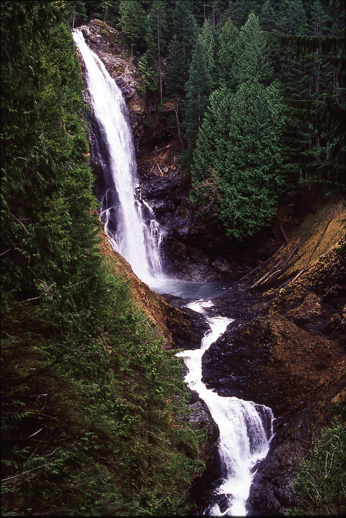
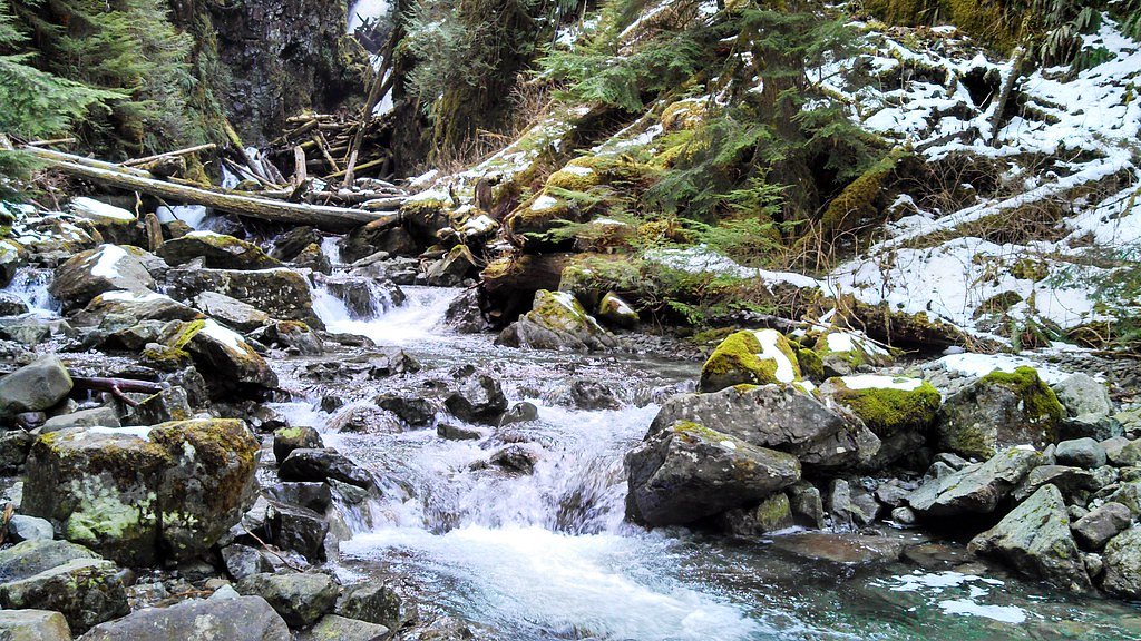
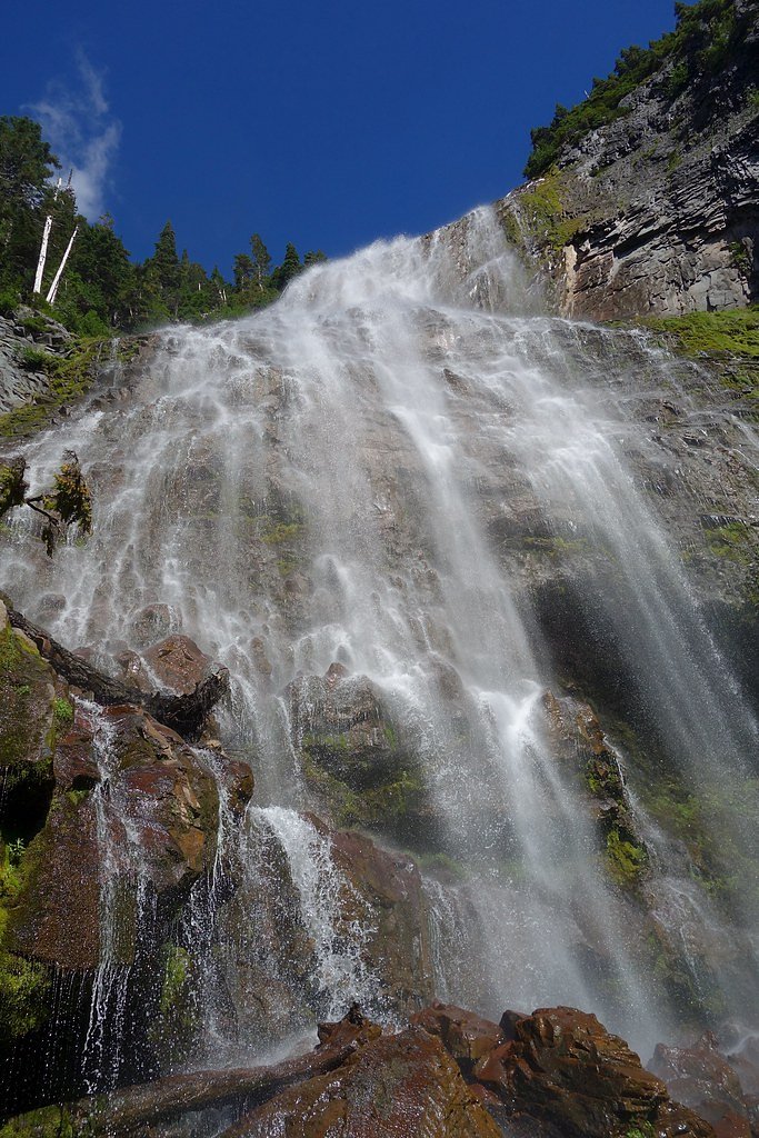
Cataract Falls
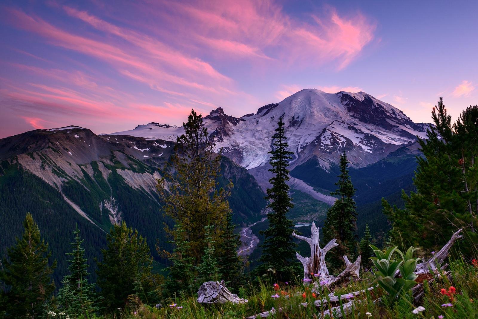
Washington • Mount Rainier National Park
By Armen Suny · Last verified Mar 2026
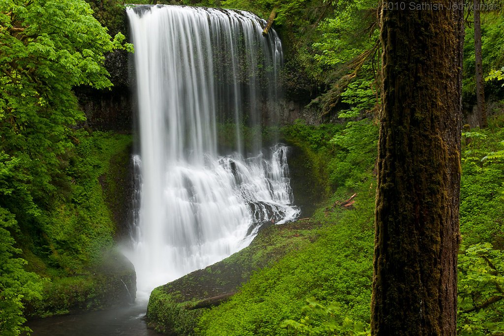
Photo Credits (5)
Difficulty
Moderate
Trail Length
2.0 miles
Trail Type
Out And Back
Elevation Gain
300 ft
About Cataract Falls
Cataract Falls is a short, scenic cascade tucked into the old-growth forests of Mount Rainier National Park. Managed by the National Park Service, the falls deliver a classic Pacific Northwest feel—moss-covered boulders, dripping ferns and the steady roar of a mountain stream slicing through a shaded canyon. It’s a popular spot for photographers and day-hikers who want a rewarding waterfall view without a long backcountry commitment. The hike to the falls is an accessible out-and-back of about 2.0 miles with roughly 300 feet of elevation gain and is typically rated moderate. Trails in this part of Mount Rainier can be wet and slippery near the water, so wear sturdy footwear. For overnight options in the park the nearest developed campground is Cougar Rock Campground, roughly 19.5 km away; otherwise this makes for a great half-day excursion while exploring Mount Rainier NP.
The Setting
Cataract Falls sits at 4,009 feet within Mount Rainier National Park, fed by the Puyallup River, in the mountains of Washington.
Trail & Hike Details
The Approach
The moderate 2.0-mile out-and-back trail gains 300 feet of elevation on the way to the falls.
Trail Description
This out-and-back trail is approximately 2.0 miles in length with around 300 feet of elevation gain and is rated moderate. The route winds through dense mixed-conifer forest on natural tread; hikers will encounter uneven ground, exposed roots and a few short, steeper pitches that contribute to the moderate difficulty. The path is generally well-marked, and no technical climbing is required, but expect wet, mossy surfaces and limited switchbacks near the creek—sturdy boots and poles are recommended for traction and balance.
What to Expect
Dogs are welcome.
Accessibility
The trail is not wheelchair accessible. Uneven terrain and elevation changes require steady footing.
Frequently Asked Questions
🐶 Are Dogs Allowed at Cataract Falls?
✅ Dogs are allowed
Are There Any Fees or Permits Required?
🆖 No fees required
🏊 Is There Swimming at Cataract Falls?
❌ Swimming is not allowed
When to Visit
Spring and early summer are ideal times to visit, as the waterfall is typically at its fullest due to snowmelt. Fall offers beautiful foliage, while winter may bring icy conditions that require extra caution.
Seasonal Access
The best time to visit is Spring, Summer, Fall, and Winter. Check with Mount Rainier National Park for current conditions.
Safety Information
The trail may be slippery, especially after rain or during winter months. Visitors should exercise caution near the waterfall and avoid climbing on wet rocks. Always stay on marked trails to ensure safety.
Current Water Conditions
459 ft³/s
Current discharge — how much water is flowing
Lower than usual for this time of year
Based on 98 years of record
4.02 ft
Water depth at gauge
7-Day Discharge Trend
What does this mean for your visit?
Flow is lower than usual for this time of year.
About This Gauge
This gauge is on a nearby waterway and may not reflect exact conditions at the falls.
7-Day Flow Outlook
Based on the USGS gauge PUYALLUP RIVER NEAR ELECTRON, WA (18 km away).
Today
Moderate
485 cfs
6/10Tomorrow
Moderate
504 cfs
6/10Mon
Moderate
497 cfs
6/10Tue
Moderate
445 cfs
8/10Wed
Moderate
456 cfs
6/10Thu
Moderate
474 cfs
6/10Fri
Moderate
491 cfs
6/10Best window: Tue — moderate flow, mostly cloudy (trip score 8/10).
Best time of year: this gauge typically runs highest from mid May to mid August, peaking in June.
How we calculate this
This is a transparent outlook, not a precise forecast. We take the waterfall's current flow strength (how it ranks against its historical normal for today, from the nearest USGS stream gauge), carry that ranking forward along the gauge's seasonal curve, and nudge it for forecast rain. Confidence is highest for the next day or two and falls further out. Always check official conditions and your own judgment before visiting — high flows can be dangerous.
Know when to go.
Get a free email alert when waterfalls near Carbonado hit peak flow. We only send when conditions are worth the trip — no weekly newsletters, no spam.
Weather Forecast
Location & Access
Getting There
Cataract Falls is located within the Gifford Pinchot National Forest. Access typically involves driving on forest roads, which may be unpaved and subject to seasonal conditions. Visitors should check local forest service updates for road conditions.
Get Directions on Google MapsParking
Parking is available near the trailhead, but spaces may be limited during peak seasons. Visitors should plan to arrive early to secure a spot.
Elevation
4,009 feet above sea level
Coordinates
46.942051° N, -121.811212° W
Land Management
Managed by NPS
Visitor Tips & Gear
Arrive early to secure parking and avoid crowds. Bring sturdy hiking shoes, water, and snacks. Check weather conditions before your visit, as the trail can become slippery in wet conditions.
As an Amazon Associate, we earn from qualifying purchases.
With 2.0 miles and 300 ft of elevation gain, sturdy boots and trekking poles will help on this moderate trail. Icy conditions are common in winter — traction cleats are a smart addition.
America the Beautiful Annual Pass
Covers entrance fees at 2,000+ federal recreation sites — required at most National Parks.

Columbia Watertight II Rain Jacket
Packs into its own pocket, seam-sealed, and keeps you dry from spray and surprise rain.

Polarized Sunglasses (Knockaround)
Cuts glare off the water so you actually see the falls — and your photos turn out better too.

Earth Pak Waterproof Dry Bag
Keeps your phone and gear dry when waterfall mist soaks everything else.

Waterproof Phone Pouch (AiRunTech)
Cheap insurance — take photos right next to the falls without killing your phone.

Timberland Euro Sprint Mid Waterproof
Trusted waterproof boot with premium leather and grippy rubber sole — reliable on rocky, wet trails.

TrailBuddy Trekking Poles
Lightweight aluminum, cork grips, and flip-locks that actually hold — a best-seller for good reason.
Where to Stay

Mountain Meadows Inn & Chalet Suites

Gateway Inn & Cabins

Lafa Cabin - Luxe A Frame Retreat with Hot Tub, Sauna, Firepit- 5 Min to Mt Rainier

Luxe Chalet at Rainier Entrance with Hot Tub-AC-WiFi
Browse vacation cabins and private rentals nearby
Unique outdoor stays — tents, yurts, and treehouses
Rent a campervan or RV for your waterfall road trip
Some links are affiliate links. We may earn a commission at no extra cost to you.
Nearby Campground
COUGAR ROCK CAMPGROUND
12.1 miles away · 184 sites
Overview Cougar Rock Campground, on the southwest side of Mt. Rainier National Park, is conveniently located near Paradise. Individual campsites are reservable on this page. Group campsite reservations can be made via Cougar Rock Group Campground. Paradise is the most popular destination in the park, with a lodge and visitor center, many miles of hiking trails and a commanding view of the mountain-the highest in the state and Cascade range. The main attraction at Mount Rainier National Park is t
Book on Recreation.govNearby Hot Springs
Hot springs near Carbonado, Washington

Mt Rainier Fumaroles
Mount Rainier fumaroles reach 162 degrees at 14,217 feet elevation, emerging 154.8 degrees above ambient at Washington's highes...

Longmire Mineral Springs
Longmire Mineral Springs flows at 77 degrees within Mount Rainier National Park at 2,758 feet elevation, emerging 31.9 degrees ...

Ohanapecosh Hot Springs
Ohanapecosh Hot Springs flows at 122 degrees within Mount Rainier National Park at 1,920 feet elevation, emerging 74.5 degrees ...
Packwood Hot Spring
Packwood Hot Spring flows at 100 degrees at 1,002 feet elevation in the lower Cascade foothills near Morton, emerging 49.8 degr...
Lester Hot Springs
This 120-degree spring sits within the City of Tacoma Watershed at 1,582 feet elevation, emerging 72.3 degrees above ambient in...
Orr Creek Warm Springs
Orr Creek Warm Springs emerges at 72 degrees in the Gifford Pinchot National Forest at 2,910 feet elevation, flowing 26.5 degre...
Looking for a soak after your hike? Explore more hot springs near Carbonado, Washington on SoakingSprings.
Explore Washington springsAdditional Information
Nearby Attractions
Nearby attractions include other waterfalls in the Gifford Pinchot National Forest, such as Panther Creek Falls and Falls Creek Falls. Mount St. Helens is also within driving distance.
Wildlife
The area is home to a variety of wildlife, including deer, birds, and small mammals. Visitors should be cautious of bears and other larger animals, especially during certain seasons.
Cities near Cataract Falls
Nearby Waterfalls
Other waterfalls named Cataract Falls
4 other waterfalls share this name across the U.S.
Writing about Cataract Falls? Embed this waterfall on your site for free.