Photo Credits (1)
Difficulty
Moderate
Trail Length
4.0 miles
Trail Type
Out And Back
Elevation Gain
450 ft
About Capote Falls
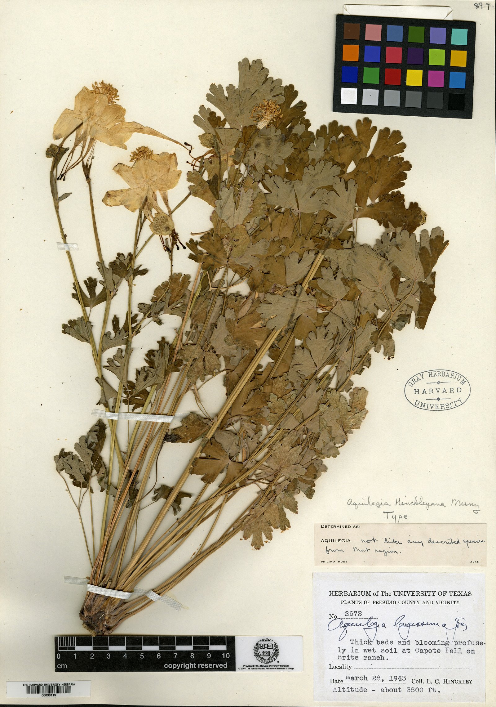
Capote Falls tumbles from Capote Creek into a narrow, verdant canyon in the Sierra Vieja of northwestern Presidio County, Texas. At up to 175 feet (53 m) the cascade is the tallest waterfall in Texas and creates a striking, moisture-rich oasis in an otherwise arid landscape. The site is ecologically significant: it’s the only known wild location of Hinckley’s columbine (Aquilegia hinckleyana), and the falls have experienced notable erosional change since 1964, giving the canyon a dynamic, weathered character that rewards patient observers and photographers alike. Access to the falls is limited and should be approached with care and respect for private land. Hikers who plan a visit typically follow a roughly 4.0-mile out-and-back route with about 450 feet of elevation gain; the effort is moderate and culminates in a dramatic view of the 175-foot drop. Because the waterfall and approach lie on private property, visitors are advised to confirm access and obtain landowner permission before setting out.
The Setting
Capote Falls sits at 3,881 feet in the mountains of Texas. At 175 feet, it is among the taller waterfalls in Texas.
Height: 175 feet
Trail & Hike Details
The Approach
The moderate 4.0-mile out-and-back trail gains 450 feet of elevation on the way to the falls.
Trail Description
Trail type: out-and-back. Length: 4.0 miles (round trip). Elevation gain: approximately 450 feet. Difficulty: moderate. Surface, grade, and formal trail class/designation are not provided in the available data; the route is commonly used by hikers to reach Capote Falls but is not described as having an official USFS trail number or maintained facilities in the provided sources. Note: the trail and waterfall lie on private property, so visitors should secure permission from landowners and plan accordingly.
What to Expect
The falls plunge 175 feet.
Accessibility
The trail is not wheelchair accessible. Uneven terrain and elevation changes require steady footing.
Frequently Asked Questions
🐶 Are Dogs Allowed at Capote Falls?
❌ Dogs are not allowed
Are There Any Fees or Permits Required?
🆖 No fees required
Permit required
Permission from the private landowners is required to visit Capote Falls. Contact the owners directly to inquire about access.
🏊 Is There Swimming at Capote Falls?
❌ Swimming is not allowed
When to Visit
Spring and fall are the best seasons to visit due to milder temperatures in the desert region.
Seasonal Access
The best time to visit is Spring and Fall. Winter access may be limited.
Safety Information
Visitors should be cautious of the remote location, potential wildlife encounters, and the lack of emergency services nearby. Always follow the landowners' guidelines.
Know when to go.
Get a free email alert when waterfalls near Valentine hit peak flow. We only send when conditions are worth the trip — no weekly newsletters, no spam.
Weather Forecast
Location & Access
Getting There
Capote Falls is located on private property, and access is strictly limited. Visitors must obtain permission from the landowners to visit the site. The waterfall is not accessible to the general public without prior arrangements.
Get Directions on Google MapsParking
Parking details are unavailable as access is restricted to those with permission from the landowners.
Elevation
3,881 feet above sea level
Coordinates
30.214321° N, -104.559645° W
Visitor Tips & Gear
If you are able to secure permission to visit, ensure you bring plenty of water, sun protection, and sturdy footwear. Be respectful of the landowners' rules and the natural environment.
As an Amazon Associate, we earn from qualifying purchases.
With 4.0 miles and 450 ft of elevation gain, sturdy boots and trekking poles will help on this moderate trail.

Columbia Watertight II Rain Jacket
Packs into its own pocket, seam-sealed, and keeps you dry from spray and surprise rain.

Earth Pak Waterproof Dry Bag
Keeps your phone and gear dry when waterfall mist soaks everything else.

Waterproof Phone Pouch (AiRunTech)
Cheap insurance — take photos right next to the falls without killing your phone.

Timberland Euro Sprint Mid Waterproof
Trusted waterproof boot with premium leather and grippy rubber sole — reliable on rocky, wet trails.

TrailBuddy Trekking Poles
Lightweight aluminum, cork grips, and flip-locks that actually hold — a best-seller for good reason.

Sawyer Squeeze Water Filter
The backcountry standard — filters 99.9% of bacteria and weighs just 3 oz.
Where to Stay
Browse vacation cabins and private rentals nearby
Unique outdoor stays — tents, yurts, and treehouses
Rent a campervan or RV for your waterfall road trip
Some links are affiliate links. We may earn a commission at no extra cost to you.
Nearby Hot Springs
Hot springs near Valentine, Texas

Capote Springs
Capote Springs flows at 99°F in the remote Chihuahuan Desert of Presidio County, approximately 29 degrees above ambient air tem...
Nixon Spring
Nixon Spring flows at 90°F near the Mexican border town of Ojinaga, running 20 degrees above the 70°F ambient temperature. Loca...
Ruidosa Hot Springs
Ruidosa Hot Springs (also known as Chinati Hot Springs and Kingston Hot Springs) flows at an exceptional 113°F, creating a volc...
Springs (Las Cienegas)
Springs at Las Cienegas flow at 86°F in the remote borderlands near Manuel Ojinaga, running 14 degrees above ambient temperatur...
Indian Hot Springs
Indian Hot Springs emerges at 117°F in Hudspeth County, creating the hottest thermal water in this dataset at 47 degrees above ...
Red Bull Spring
Red Bull Spring flows at 99°F just 137 feet from roadside in Hudspeth County, providing immediate access to thermal water 30 de...
Looking for a soak after your hike? Explore more hot springs near Valentine, Texas on SoakingSprings.
Explore Texas springsAdditional Information
Nearby Attractions
The surrounding area is remote, but the nearby Guadalupe Mountains National Park offers hiking and scenic views.
Wildlife
The area around Capote Falls may host desert wildlife such as birds, lizards, and small mammals.
Cities near Capote Falls
Writing about Capote Falls? Embed this waterfall on your site for free.