Buckeye Falls
Tennessee • 475 ft
By Armen Suny · Last verified May 2026
Difficulty
Hard
Trail Length
8.0 miles
Trail Type
Out And Back
Elevation Gain
2 ft
About Buckeye Falls
Buckeye Falls is one of the tallest waterfalls in the eastern United States, located in the remote and rugged terrain of the Cherokee National Forest in Tennessee. The waterfall is seasonal and may not flow during dry periods, but after heavy rains, it cascades dramatically down a steep cliff face.
The Setting
Buckeye Falls sits at 2,953 feet within Cherokee National Forest, fed by the Big Limestone Creek, in the hills of Tennessee. At 475 feet, it is among the taller waterfalls in Tennessee.
Height: 475 feet
Trail & Hike Details
The Approach
The hard hike follows Longarm Trail (#1901), a 8.0-mile out-and-back trail over n/a. Expect 2 feet of elevation gain with grades of N/A.
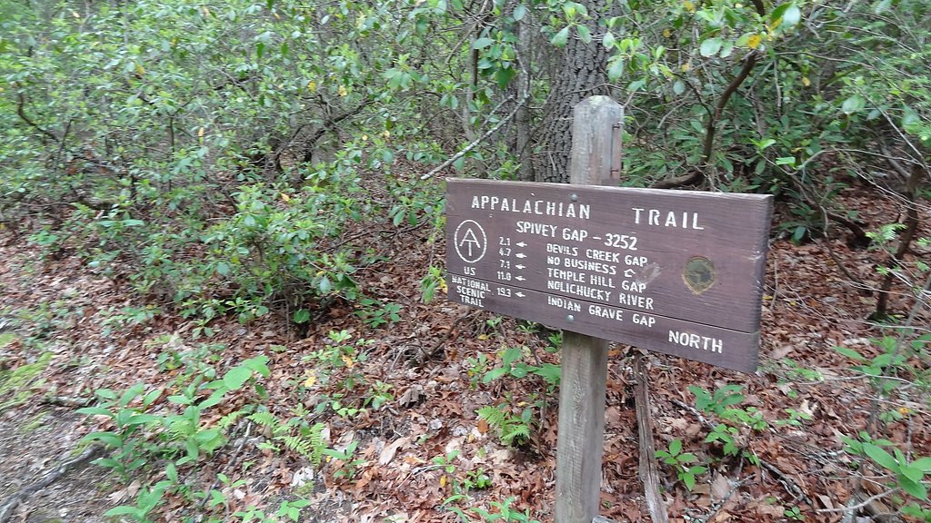
USFS Trail
LONGARM TRAIL #1901
Trail Class
Class 0
Surface
Avg Grade
USFS Segment
3.62 miTrail Description
The trail to Buckeye Falls is challenging and involves steep climbs, creek crossings, and sections of unmarked or overgrown paths. Hikers should be prepared for rugged terrain and bring a map or GPS device, as the trail is not well-defined in many areas.
What to Expect
The falls plunge a dramatic 475 feet. Dogs are welcome.
Accessibility
The trail involves steep, uneven terrain with significant elevation change and is not accessible to mobility devices.
Frequently Asked Questions
🐶 Are Dogs Allowed at Buckeye Falls?
✅ Dogs are allowed
Are There Any Fees or Permits Required?
🆖 No fees required
🏊 Is There Swimming at Buckeye Falls?
❌ Swimming is not allowed
When to Visit
Spring and early summer are the best times to visit, as the waterfall is more likely to be flowing due to seasonal rains.
Seasonal Access
The best time to visit is Spring, Summer, and Fall. Winter access may be limited. Check with Cherokee National Forest for seasonal road closures.
Safety Information
The trail to Buckeye Falls is remote and challenging. Hikers should be prepared for creek crossings, steep climbs, and unmarked paths. Cell phone service is unreliable in the area, so inform someone of your plans before heading out. Carry a first aid kit and be aware of wildlife, including black bears.
Current Water Conditions
25 ft³/s
Current discharge — how much water is flowing
Lower than usual for this time of year
Based on 28 years of record
2.99 ft
Water depth at gauge
7-Day Discharge Trend
What does this mean for your visit?
Flow is lower than usual for this time of year.
About This Gauge
This gauge is on a nearby waterway and may not reflect exact conditions at the falls.
7-Day Flow Outlook
Based on the USGS gauge BIG LIMESTONE CREEK NEAR LIMESTONE, TN (15 km away).
Today
Moderate
28 cfs
4/10Tomorrow
Moderate
42 cfs
4/10Mon
Moderate
34 cfs
4/10Tue
Moderate
32 cfs
4/10Wed
Low
28 cfs
6/10Thu
Moderate
34 cfs
4/10Fri
Moderate
30 cfs
4/10Best window: Wed — low flow, sunny (trip score 6/10).
Best time of year: this gauge typically runs highest from mid February to late April, peaking in March.
How we calculate this
This is a transparent outlook, not a precise forecast. We take the waterfall's current flow strength (how it ranks against its historical normal for today, from the nearest USGS stream gauge), carry that ranking forward along the gauge's seasonal curve, and nudge it for forecast rain. Confidence is highest for the next day or two and falls further out. Always check official conditions and your own judgment before visiting — high flows can be dangerous.
Know when to go.
Get a free email alert when waterfalls near Banner Hill hit peak flow. We only send when conditions are worth the trip — no weekly newsletters, no spam.
Weather Forecast
Location & Access
Getting There
Buckeye Falls is located in the Clark Creek area of the Cherokee National Forest. Access to the falls requires navigating unmarked trails and bushwhacking through dense forest. The trailhead is typically accessed via Clark Creek Road, but the route is not well-maintained.
Get Directions on Google MapsParking
Parking is available near the Clark Creek trailhead, but spaces are limited and the area may be difficult to access during wet or snowy conditions.
Elevation
2,953 feet above sea level
Coordinates
36.087606° N, -82.575143° W
Land Management
Managed by USFS
Visitor Tips & Gear
Wear sturdy hiking boots and bring plenty of water and snacks. Start early to allow enough time for the hike and return before dark. Check weather conditions before your trip, as the trail can become dangerous during or after rain.
As an Amazon Associate, we earn from qualifying purchases.
This challenging 8.0 miles trail gains 2 ft in elevation — come prepared with proper hiking boots and trekking poles. Sun exposure on the trail makes good sun protection a must in summer.

Sawyer Squeeze Water Filter
The backcountry standard — filters 99.9% of bacteria and weighs just 3 oz.

Columbia Watertight II Rain Jacket
Packs into its own pocket, seam-sealed, and keeps you dry from spray and surprise rain.

Earth Pak Waterproof Dry Bag
Keeps your phone and gear dry when waterfall mist soaks everything else.

Waterproof Phone Pouch (AiRunTech)
Cheap insurance — take photos right next to the falls without killing your phone.

Timberland Euro Sprint Mid Waterproof
Trusted waterproof boot with premium leather and grippy rubber sole — reliable on rocky, wet trails.

TrailBuddy Trekking Poles
Lightweight aluminum, cork grips, and flip-locks that actually hold — a best-seller for good reason.
Where to Stay

Treetops Cabin easy to Asheville with fast wifi and great view

Gipson Retreat in Greeneville

Quality Inn Greeneville - Tusculum

Cozy 1 bedroom cabin in the heart of Jonesborough
Browse vacation cabins and private rentals nearby
Unique outdoor stays — tents, yurts, and treehouses
Rent a campervan or RV for your waterfall road trip
Some links are affiliate links. We may earn a commission at no extra cost to you.
Nearby Campground
Bald Mountains
1.5 miles away · 0 sites
Most of the area is remote backcountry, including Bald Mountain Ridge Scenic Area and Sampson Mountain Wilderness. Roads are limited, but forty-plus miles of trail access the forest.The area is known for its diverse populations of wildflowers and a number of waterfalls, including 60-foot fan-shaped Margarette Falls and Sill Branch Falls. Try fishing Nolichucky River, Horse Creek, Dry Creek and Clark Creek. Horse Creek and Old Forge Recreation areas offer picnicking, water play and camping.Bald
Book on Recreation.govNearby Hot Springs
Hot springs near Banner Hill, Tennessee

Looking for a soak after your hike? Explore more hot springs near Banner Hill, Tennessee on SoakingSprings.
Explore Tennessee springsAdditional Information
Nearby Attractions
Other waterfalls and hiking trails in the Cherokee National Forest, including Sill Branch Falls and Margarette Falls.
Wildlife
The area is home to black bears, deer, and a variety of bird species. Exercise caution and follow bear safety guidelines.
Cities near Buckeye Falls
Nearby Waterfalls
Writing about Buckeye Falls? Embed this waterfall on your site for free.