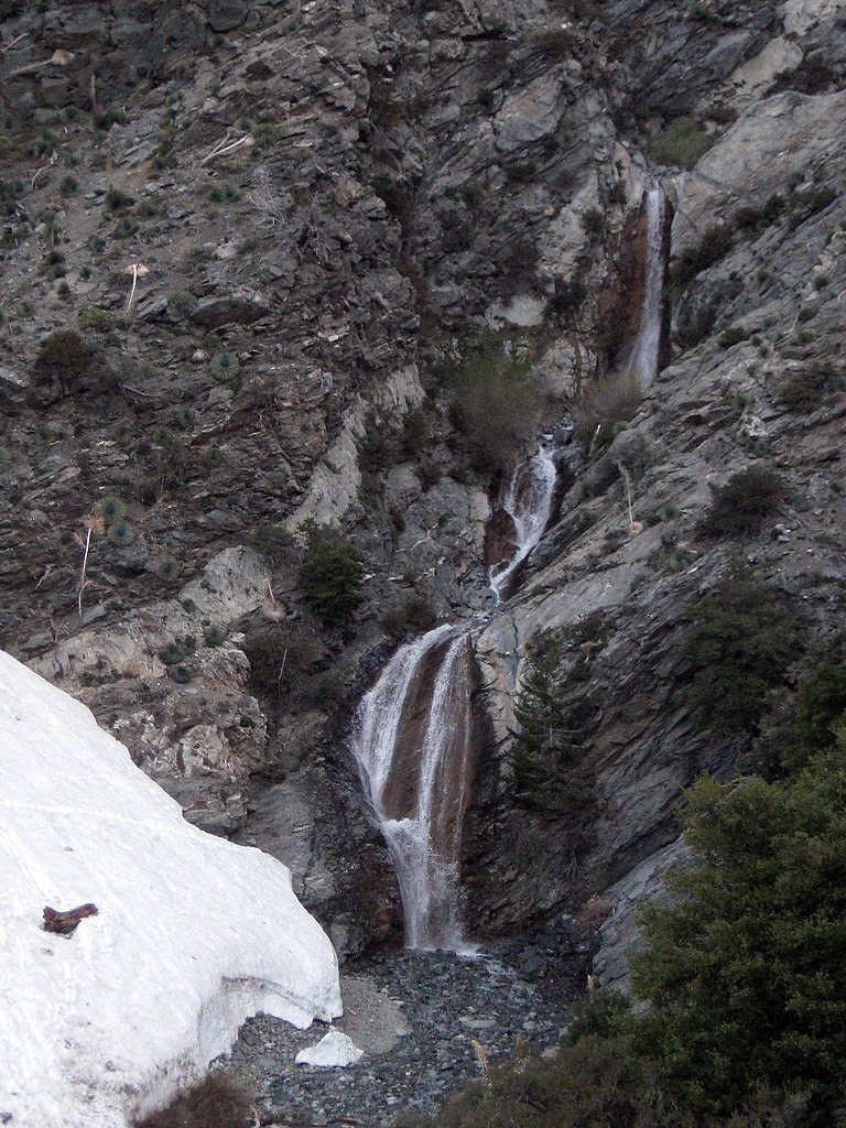
Bonita Falls
California • 160 ft
By Armen Suny · Last verified May 2026
Difficulty
Moderate
Trail Length
1.5 miles
Trail Type
Out And Back
Elevation Gain
200 ft
About Bonita Falls
Bonita Falls is a stunning 160-foot waterfall located in the San Bernardino National Forest, near Lytle Creek, California. It is one of the tallest waterfalls in Southern California and is a popular destination for hikers and nature enthusiasts.
The Setting
Bonita Falls sits at 3,327 feet within San Bernardino National Forest, in the mountains of California. At 160 feet, it is among the taller waterfalls in California.
Height: 160 feet
Trail & Hike Details
The Approach
The moderate hike follows Chaparral Neighborhood (#6W03), a 1.5-mile out-and-back trail over pavement. Expect 200 feet of elevation gain with grades of 0-5%. The trail is fully developed (Class 5).
USFS Trail
CHAPARRAL NEIGHBORHOOD #6W03
Trail Class
Fully Developed
Surface
Avg Grade
USFS Segment
0.81 miTrail Description
The trail to Bonita Falls is relatively short but can be challenging due to uneven terrain and the need to cross a creek. The path is not officially maintained, so hikers should be prepared for rocky sections and potential navigation challenges. The waterfall is located in a scenic canyon surrounded by lush vegetation.
What to Expect
The falls plunge 160 feet. Dogs are welcome.
Accessibility
The trail is paved and may be accessible to wheelchairs and strollers. Contact the managing agency to confirm current conditions.
Frequently Asked Questions
🐶 Are Dogs Allowed at Bonita Falls?
✅ Dogs are allowed
Are There Any Fees or Permits Required?
🤑 Fee: $5.00
Permit required
An Adventure Pass is required for parking in the area. It can be purchased at local vendors or online.
🏊 Is There Swimming at Bonita Falls?
❌ Swimming is not allowed
When to Visit
Spring is the best time to visit Bonita Falls, as the waterfall is typically at its fullest due to snowmelt and seasonal rains. Early mornings or weekdays are ideal to avoid crowds.
Seasonal Access
The best time to visit is Spring, Summer, Fall, and Winter. Check with San Bernardino National Forest for seasonal road closures.
Safety Information
The trail is unmaintained and can be slippery or unstable in places. Be cautious when crossing the creek, especially after rain. Graffiti and litter are common in the area, so watch for broken glass or other hazards. Always carry enough water and avoid hiking alone.
Current Water Conditions
30 ft³/s
Current discharge — how much water is flowing
Much lower than usual for this time of year
Based on 107 years of record
3.01 ft
Water depth at gauge
7-Day Discharge Trend
What does this mean for your visit?
Flow is well below normal for this time of year, so the waterfall may be a trickle.
About This Gauge
7-Day Flow Outlook
Based on the USGS gauge LYTLE C NR FONTANA CA (5 km away).
Today
Barely Flowing
30 cfs
5/10Tomorrow
Barely Flowing
30 cfs
5/10Tue
Barely Flowing
30 cfs
5/10Wed
Barely Flowing
30 cfs
5/10Thu
Barely Flowing
30 cfs
5/10Fri
Barely Flowing
30 cfs
5/10Sat
Barely Flowing
30 cfs
5/10Best window: Today — barely flowing flow, sunny (trip score 5/10).
Best time of year: this gauge typically runs highest from mid March to late March, peaking in March.
How we calculate this
This is a transparent outlook, not a precise forecast. We take the waterfall's current flow strength (how it ranks against its historical normal for today, from the nearest USGS stream gauge), carry that ranking forward along the gauge's seasonal curve, and nudge it for forecast rain. Confidence is highest for the next day or two and falls further out. Always check official conditions and your own judgment before visiting — high flows can be dangerous.
Know when to go.
Get a free email alert when waterfalls near Lytle Creek hit peak flow. We only send when conditions are worth the trip — no weekly newsletters, no spam.
Weather Forecast
Location & Access
Getting There
Bonita Falls is accessed via the Bonita Falls Trailhead, located off Lytle Creek Road. The trailhead is unmarked but can be found near a dirt parking area. Visitors will need to cross a creek and follow an unofficial trail to reach the falls.
Get Directions on Google MapsParking
Parking is available in a dirt lot near the trailhead. An Adventure Pass is required to park in the area, which can be purchased at local stores or online.
Elevation
3,327 feet above sea level
Coordinates
34.230285° N, -117.504773° W
Land Management
Managed by USFS
Visitor Tips & Gear
Wear sturdy shoes with good traction, as the trail can be rocky and uneven. Bring plenty of water, especially during warmer months. Arrive early to secure parking and avoid crowds. Be cautious when crossing the creek, especially after rainfall.
As an Amazon Associate, we earn from qualifying purchases.
With 1.5 miles and 200 ft of elevation gain, sturdy boots and trekking poles will help on this moderate trail. Icy conditions are common in winter — traction cleats are a smart addition.

Columbia Watertight II Rain Jacket
Packs into its own pocket, seam-sealed, and keeps you dry from spray and surprise rain.

Earth Pak Waterproof Dry Bag
Keeps your phone and gear dry when waterfall mist soaks everything else.

Waterproof Phone Pouch (AiRunTech)
Cheap insurance — take photos right next to the falls without killing your phone.

Timberland Euro Sprint Mid Waterproof
Trusted waterproof boot with premium leather and grippy rubber sole — reliable on rocky, wet trails.

TrailBuddy Trekking Poles
Lightweight aluminum, cork grips, and flip-locks that actually hold — a best-seller for good reason.

Kahtoola MICROspikes
Cult-favorite traction cleats that grip ice and wet rock — essential for winter waterfall hikes.
Where to Stay

Comfort Inn Fontana

Ayres Hotel Rialto Fontana

La Quinta Inn & Suites by Wyndham Ontario Airport

Holiday Inn Ontario Airport - California by IHG
Browse vacation cabins and private rentals nearby
Unique outdoor stays — tents, yurts, and treehouses
Rent a campervan or RV for your waterfall road trip
Some links are affiliate links. We may earn a commission at no extra cost to you.
Nearby Campground
Lytle Creek - Cajon Pass Recreation Area
1.4 miles away · 0 sites
Includes the Lytle Creek, Cucamonga Canyon, Cajon Pass, and City Creek areas. Also includes the Cucamonga and Sheep Mountain Wilderness Areas.
Book on Recreation.govNearby Hot Springs
Hot springs near Lytle Creek, California

Tylers Bath Spring
Tyler's Bath Spring emerges at 92 degrees in the San Bernardino National Forest, producing water 30 degrees warmer than the amb...

Arrowhead Springs, Waterman Hot Spr
Arrowhead Springs and Waterman Hot Springs discharge at 194°F (90°C) in the San Bernardino Mountains, among Southern California...

Warm Spring, Hot Spring
Deep Creek Hot Springs flows at a robust 108°F in the San Bernardino National Forest near Lake Arrowhead. With 352 mg/L total d...
Unnamed Spring San Bernardino County
Deep in the San Bernardino National Forest near Mentone, this 90-degree spring flows 26 degrees above ambient in mountains wher...
Glen Ivy Hot Springs
Glen Ivy Hot Springs emerges at 131 degrees Fahrenheit, the warmest feature among these Riverside County springs and displaying...

Pan Hot Springs
Pan Hot Springs flows at 88 degrees Fahrenheit at 6,717 feet elevation near Big Bear City, creating a 35-degree thermal anomaly...
Looking for a soak after your hike? Explore more hot springs near Lytle Creek, California on SoakingSprings.
Explore California springsAdditional Information
Nearby Attractions
Lytle Creek, Cucamonga Wilderness, and other hiking trails in the San Bernardino National Forest.
Wildlife
The area is home to various wildlife, including birds, lizards, and small mammals. Be cautious of snakes, especially during warmer months.
Cities near Bonita Falls
Nearby Waterfalls
Writing about Bonita Falls? Embed this waterfall on your site for free.