
Photo Credits (5)
Difficulty
Moderate
Trail Length
2.4 miles
Trail Type
Out And Back
Elevation Gain
350 ft
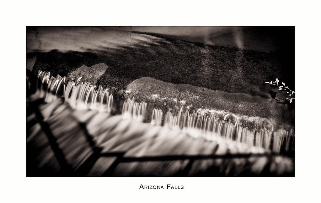
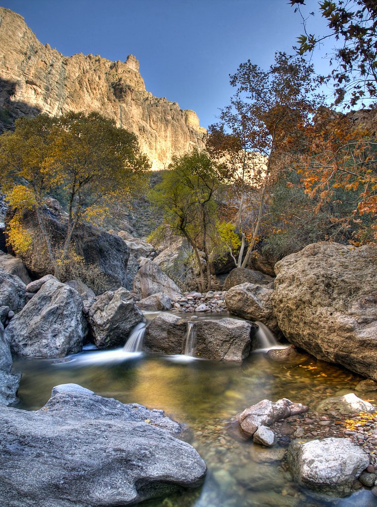
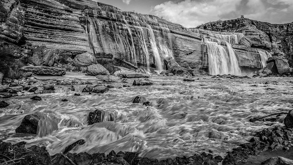
About Black Falls
Black Falls tumbles across dark volcanic ledges in a braided series of sheets and steps, the very basalt that gives the cascades their name. Unlike a single sheer drop, the water spreads and steps down over the volcanic formations, so the falls are at their most impressive during spring runoff or after rains and can shrink to trickles in the dry season. The landscape feels remote and rugged, rewarding visitors who appreciate geology, quiet desert scenery, and low-key, off-the-beaten-path experiences. Reaching the cascades involves a short but engaging outing: the most common approach is an approximately 2.4-mile out-and-back hike with about 350 feet of elevation gain and is generally rated moderate. There is no developed, signed or officially numbered USFS trail to the base, so expect route-finding across uneven volcanic rock and natural desert terrain rather than a maintained tread. Come prepared with sturdy footwear, plenty of water, and time to move slowly over rocky ledges while you enjoy the unique geology and seasonal flow patterns.
The Setting
Black Falls sits at 4,281 feet along the Little Colorado River, in the mountains of Arizona.
Trail & Hike Details
The Approach
The moderate 2.4-mile out-and-back trail gains 350 feet of elevation on the way to the falls.
Trail Description
Length: ~2.4 miles round-trip (out-and-back). Elevation gain: ~350 feet. Difficulty: Moderate. Surface and route: There is no maintained or officially numbered USFS trail to Black Falls. The approach crosses open, undeveloped terrain made up primarily of volcanic rock ledges and natural desert ground; hikers should expect uneven footing, minor boulder-hopping and short sections of informal social tread. Grade and formal trail class data are not available for this unmarked route. Navigation: route-finding skills recommended—use a GPS or map, watch for natural cairns or worn approach lines, and allow extra time for careful travel. Footwear and planning: wear sturdy, grippy shoes, carry sufficient water, and be prepared for limited or no facilities at the site.
What to Expect
Expect a remote and rugged environment with volcanic rock formations and seasonal water flow. The falls may be dry during periods of low rainfall. The area offers scenic views and a sense of solitude.
Accessibility
The trail is not wheelchair accessible. Uneven terrain and elevation changes require steady footing.
Frequently Asked Questions
🐶 Are Dogs Allowed at Black Falls?
❌ Dogs are not allowed
Are There Any Fees or Permits Required?
🆖 No fees required
🏊 Is There Swimming at Black Falls?
❌ Swimming is not allowed
When to Visit
The best time to visit is after recent rainfall or snowmelt, typically in spring or after summer monsoons, when the water flow is more likely.
Seasonal Access
The best time to visit is Spring, Summer, Fall, and Winter. Watch for flash flood warnings during monsoon season (July through September).
Safety Information
Be cautious of uneven and slippery rocks. The area is remote, so bring sufficient supplies and let someone know your plans. Avoid visiting during or after heavy rain, as roads may become impassable.
Current Water Conditions
Based on a USGS gauge 28.8 miles away
0 ft³/s
Current discharge — how much water is flowing
Based on 78 years of record
1.73 ft
Water depth at gauge
About This Gauge
This gauge is on a regional waterway. Conditions at the falls may differ, especially after local rain.
7-Day Flow Outlook
Based on the USGS gauge LITTLE COLORADO RIVER NEAR CAMERON, AZ (46 km away).
Best time of year: this gauge typically runs highest from early March to late April, peaking in March.
How we calculate this
This is a transparent outlook, not a precise forecast. We take the waterfall's current flow strength (how it ranks against its historical normal for today, from the nearest USGS stream gauge), carry that ranking forward along the gauge's seasonal curve, and nudge it for forecast rain. Confidence is highest for the next day or two and falls further out. Always check official conditions and your own judgment before visiting — high flows can be dangerous.
Know when to go.
Get a free email alert when waterfalls near Cameron hit peak flow. We only send when conditions are worth the trip — no weekly newsletters, no spam.
Weather Forecast
Location & Access
Getting There
Black Falls is located near the Little Colorado River, approximately 45 minutes northeast of Flagstaff, Arizona. Access is via unpaved roads, and a high-clearance vehicle is recommended. Visitors should check local conditions before traveling, as the area can become inaccessible after heavy rain.
Get Directions on Google MapsParking
There is no designated parking area. Visitors typically park along the roadside near the falls, but space is limited.
Elevation
4,281 feet above sea level
Coordinates
35.578913° N, -111.284397° W
Visitor Tips & Gear
Check weather conditions before visiting, as the area can become muddy and difficult to access after rain. Bring plenty of water, as there are no facilities nearby. A high-clearance vehicle is recommended for the unpaved roads.
As an Amazon Associate, we earn from qualifying purchases.
With 2.4 miles and 350 ft of elevation gain, sturdy boots and trekking poles will help on this moderate trail. Icy conditions are common in winter — traction cleats are a smart addition.

Columbia Watertight II Rain Jacket
Packs into its own pocket, seam-sealed, and keeps you dry from spray and surprise rain.

Polarized Sunglasses (Knockaround)
Cuts glare off the water so you actually see the falls — and your photos turn out better too.

Earth Pak Waterproof Dry Bag
Keeps your phone and gear dry when waterfall mist soaks everything else.

Waterproof Phone Pouch (AiRunTech)
Cheap insurance — take photos right next to the falls without killing your phone.

Timberland Euro Sprint Mid Waterproof
Trusted waterproof boot with premium leather and grippy rubber sole — reliable on rocky, wet trails.

TrailBuddy Trekking Poles
Lightweight aluminum, cork grips, and flip-locks that actually hold — a best-seller for good reason.
Where to Stay

Tiny home near Grand Canyon sleeps 5, epic views!

Beautiful Views! Home near Grand Canyon, Flagstaff

Family Home in Flagstaff w/ Surrounding Mtn Views!
Browse vacation cabins and private rentals nearby
Unique outdoor stays — tents, yurts, and treehouses
Rent a campervan or RV for your waterfall road trip
Some links are affiliate links. We may earn a commission at no extra cost to you.
Nearby Campground
Bonito Campground (AZ)
20.5 miles away · 44 sites
Overview Bonito Campground is located 18 miles northeast of Flagstaff, near Sunset Crater/Wupatki National Monument. Elevation is 6,900 feet. Bonito Campground is named for the Bonito Lava Flow which oozed across this high desert plain some 900 years ago. That river of liquid rock, now frozen forever, is just one of the many remnants of volcanic activity which lend an otherwordly appearance to this starkly beautiful place. Recreation Hiking, sightseeing, wildlife viewing are popular activities.
Book on Recreation.govAdditional Information
Nearby Attractions
The Little Colorado River Gorge and the city of Flagstaff are nearby attractions.
Wildlife
The area is home to desert wildlife, including birds, lizards, and small mammals. Be cautious of snakes, especially during warmer months.
Cities near Black Falls
Other waterfalls named Black Falls
2 other waterfalls share this name across the U.S.
Writing about Black Falls? Embed this waterfall on your site for free.