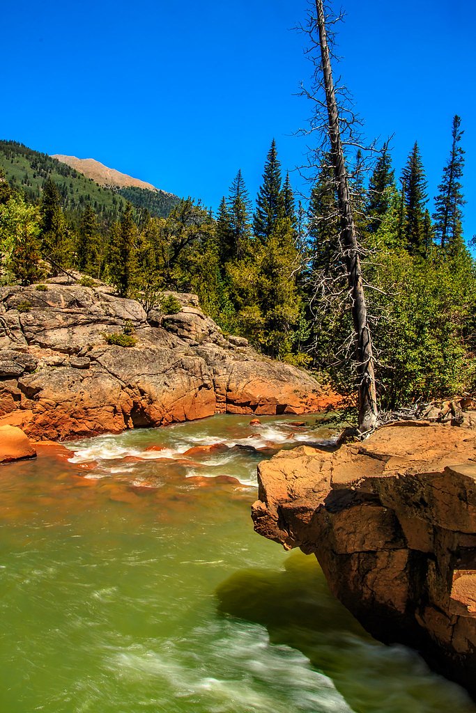
Bedrock Falls
By Armen Suny · Last verified May 2026

Photo Credits (5)
Difficulty
Moderate
Trail Length
2.4 miles
Trail Type
Out And Back
Elevation Gain
350 ft
About Bedrock Falls
Bedrock Falls is a rugged, quietly scenic cascade tucked into the high-country of Colorado, managed by the U.S. Forest Service and nestled within San Isabel National Forest. The most direct approach follows the USFS-designated Missouri Gulch Trail (Trail #1469), and while the route feels remote, it rewards hikers with a peaceful waterfall setting and classic native-rock scenery. Hikers typically tackle the outing as a moderate out-and-back, making for an approachable day trip for those comfortable with uneven backcountry terrain. The area is overseen by the USFS, and camping is available nearby at Crescent Mining Camp campground, about 8.34 km from the falls, for anyone wanting to extend their visit. With a relatively modest elevation gain and a short but varied trail, Bedrock Falls is an inviting choice for hikers seeking solitude and a taste of San Isabel National Forest’s wilderness without committing to a multi-day trek.
The Setting
Bedrock Falls sits at 11,253 feet within San Isabel National Forest, fed by the Arkansas River, in the high alpine of Colorado.
Trail & Hike Details
The Approach
The moderate hike follows Missouri Gulch (#1469), a 2.4-mile out-and-back trail over natural surface. Expect 350 feet of elevation gain. The trail is developed (Class 3).
USFS Trail
MISSOURI GULCH #1469
Trail Class
Developed
Surface
USFS Segment
0.59 miTrail Description
The approach to Bedrock Falls follows the USFS Missouri Gulch Trail (Trail #1469). The Forest Service records Missouri Gulch at 0.59 GIS miles, and many visitors travel a roughly 2.4-mile out-and-back route to reach the falls (total round trip), with about 350 feet of elevation gain. The trail is rated moderate in difficulty and is classified by the USFS as Class 3; the mapped tread surface is native material. Expect uneven footing and typical backcountry trail features — the route is native-surface singletrack and not paved, and is best attempted with sturdy footwear and basic navigation awareness.
What to Expect
Expect a remote and tranquil setting with limited amenities. The falls are surrounded by natural wilderness, offering opportunities for photography and quiet reflection.
Accessibility
The trail is not wheelchair accessible. Uneven terrain and elevation changes require steady footing.
Frequently Asked Questions
🐶 Are Dogs Allowed at Bedrock Falls?
❌ Dogs are not allowed
Are There Any Fees or Permits Required?
🆖 No fees required
🏊 Is There Swimming at Bedrock Falls?
❌ Swimming is not allowed
When to Visit
Spring and early summer are typically the best times to visit, as snowmelt may enhance the flow of the waterfall.
Seasonal Access
The best time to visit is Spring, Summer, and Fall. Access roads and trails may close during winter due to snow. Check with San Isabel National Forest for seasonal road closures.
Safety Information
The area may have uneven terrain, limited cell service, and potential wildlife encounters. Visitors should be prepared for backcountry conditions and carry safety essentials.
Current Water Conditions
272 ft³/s
Current discharge — how much water is flowing
Much lower than usual for this time of year
Based on 27 years of record
11.46 ft
Water depth at gauge
7-Day Discharge Trend
What does this mean for your visit?
Flow is well below normal for this time of year, so the waterfall may be a trickle.
About This Gauge
This gauge is on a nearby waterway and may not reflect exact conditions at the falls.
7-Day Flow Outlook
Based on the USGS gauge ARKANSAS RIVER BELOW GRANITE, CO (11 km away).
Today
Moderate
272 cfs
9/10Tomorrow
Moderate
237 cfs
9/10Mon
Moderate
224 cfs
9/10Tue
Moderate
212 cfs
9/10Wed
Moderate
200 cfs
9/10Thu
Moderate
176 cfs
9/10Fri
Moderate
176 cfs
9/10Best window: Today — moderate flow, sunny (trip score 9/10).
Best time of year: this gauge typically runs highest from mid May to early July, peaking in June.
How we calculate this
This is a transparent outlook, not a precise forecast. We take the waterfall's current flow strength (how it ranks against its historical normal for today, from the nearest USGS stream gauge), carry that ranking forward along the gauge's seasonal curve, and nudge it for forecast rain. Confidence is highest for the next day or two and falls further out. Always check official conditions and your own judgment before visiting — high flows can be dangerous.
Know when to go.
Get a free email alert when waterfalls near Buena Vista hit peak flow. We only send when conditions are worth the trip — no weekly newsletters, no spam.
Weather Forecast
Location & Access
Getting There
The exact location of Bedrock Falls is not widely documented, but it is believed to be accessible via backcountry trails in a remote area of Colorado. Visitors should research local maps and consult with park services for precise directions.
Get Directions on Google MapsParking
Parking availability is unclear. Visitors may need to park at a trailhead or designated area nearby and hike to the falls.
Elevation
11,253 feet above sea level
Coordinates
38.944439° N, -106.340024° W
Land Management
Managed by USFS
Visitor Tips & Gear
Bring a detailed map or GPS device, as the area may lack clear signage. Wear sturdy hiking boots and pack plenty of water and snacks. Check weather conditions before your visit.
This trail sits at 11,253 ft — roughly 30% less oxygen than sea level
Extreme AltitudeAt this elevation, altitude sickness is a real concern. Monitor how you feel, take frequent rest breaks, and descend if symptoms worsen. Visitors arriving from lower elevations should allow time to acclimatize.
As an Amazon Associate, we earn from qualifying purchases.

Coppertone Sport SPF 50 Sunscreen
UV intensity jumps ~4% per 1,000 ft — at this elevation you can burn in half the time.

Sun Bum SPF 30 Lip Balm (3-Pack)
Lips have almost no natural UV protection and burn fast in thin, dry mountain air.

Liquid I.V. Electrolyte Packets
You lose moisture ~2x faster at elevation — electrolytes help you absorb water efficiently.

ROCKNIGHT Polarized UV400 Sunglasses
High-altitude glare off rock and water is intense — UV400 lenses block 99%+ of UVA/UVB.

Boost Oxygen 10L Canister (2-Pack)
Portable supplemental oxygen for quick relief from headaches and shortness of breath.

Altitude Rx OxyBoost Complex
Antioxidant formula designed to support your body's natural altitude acclimation.

Fingertip Pulse Oximeter
Monitor blood oxygen in real time — SpO2 commonly drops to 85–90% above 10,000 ft.
As an Amazon Associate, we earn from qualifying purchases.
With 2.4 miles and 350 ft of elevation gain, sturdy boots and trekking poles will help on this moderate trail. Sun exposure on the trail makes good sun protection a must in summer.

Polarized Sunglasses (Knockaround)
Cuts glare off the water so you actually see the falls — and your photos turn out better too.

Columbia Watertight II Rain Jacket
Packs into its own pocket, seam-sealed, and keeps you dry from spray and surprise rain.

Earth Pak Waterproof Dry Bag
Keeps your phone and gear dry when waterfall mist soaks everything else.

Waterproof Phone Pouch (AiRunTech)
Cheap insurance — take photos right next to the falls without killing your phone.

Timberland Euro Sprint Mid Waterproof
Trusted waterproof boot with premium leather and grippy rubber sole — reliable on rocky, wet trails.

TrailBuddy Trekking Poles
Lightweight aluminum, cork grips, and flip-locks that actually hold — a best-seller for good reason.
Where to Stay

Whitewater Peak - Cozy Retreat with Scenic Views

Paradise Home 20 Mins to Disney with Pool and Waterpark on Property

The Gant

Mount Princeton Hot Springs Resort
Browse vacation cabins and private rentals nearby
Unique outdoor stays — tents, yurts, and treehouses
Rent a campervan or RV for your waterfall road trip
Some links are affiliate links. We may earn a commission at no extra cost to you.
Nearby Campground
CRESCENT MINING CAMP
5.2 miles away · 1 sites
Overview Cabin campers can escape the city - and escape modern day amenities - by staying at the fully rustic, historic Crescent Mining Camp cabins. The cabins offer a true old fashioned taste of life on the mine in the 19th century, with no electricity or running water. Visitors can focus on the sounds of nature and the incredible views of the Rocky Mountains from its creekside location. The mining camp was built in the 1890s during the boom of mining and milling in Clear Creek Canyon. Miners so
Book on Recreation.govNearby Hot Springs
Hot springs near Buena Vista, Colorado
Cottonwood Hot Springs
Cottonwood Hot Springs emerges at an extraordinary 136 degrees Fahrenheit near Buena Vista, a scorching roadside spring in the ...

Hortense Hot Spring
Hortense Hot Spring ranks among Colorado's most thermally impressive geothermal features, with water emerging at a blistering 1...
Aqua Hot Spring
Aqua Hot Spring emerges at 102 degrees Fahrenheit in Chaffee County, notable for its roadside access and balanced mineral compo...
Mount Princeton Hot Springs
Mount Princeton Hot Springs flows at 133°F in Chaffee County at 8,142 feet elevation near Buena Vista, where developed resort f...
Rhodes Warm Spring
Rhodes Warm Spring emerges at 75°F at 10,172 feet elevation in the high mountain country of Park County near Fairplay, offering...
Cement Creek Hot Spring
Cement Creek Hot Spring flows at 77 degrees Fahrenheit near Crested Butte at 9,223 feet elevation. A moderate 430-foot walk thr...
Looking for a soak after your hike? Explore more hot springs near Buena Vista, Colorado on SoakingSprings.
Explore Colorado springsAdditional Information
Nearby Attractions
Nearby attractions are not well-documented but may include other natural features or hiking trails in the surrounding area.
Wildlife
The area may be home to various wildlife, including deer, birds, and potentially bears. Visitors should practice proper wildlife safety.
Cities near Bedrock Falls
Nearby Waterfalls
Writing about Bedrock Falls? Embed this waterfall on your site for free.