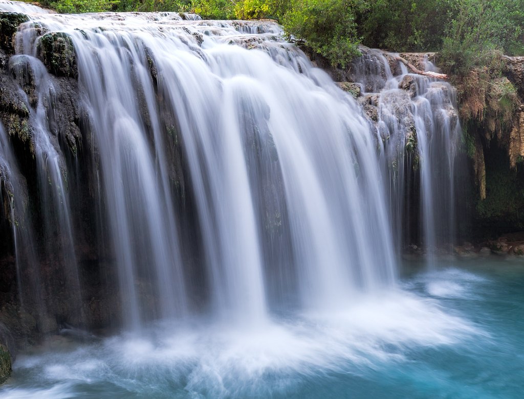
Beaver Falls
Arizona • Grand Canyon National Park
By Armen Suny · Last verified Mar 2026
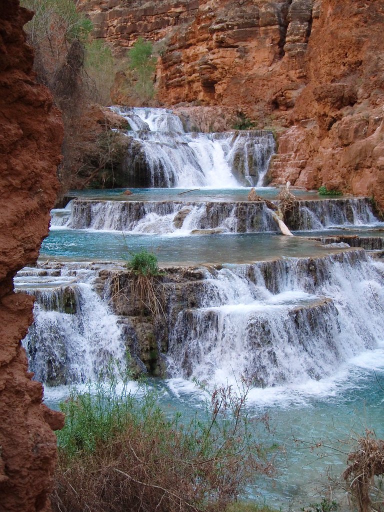
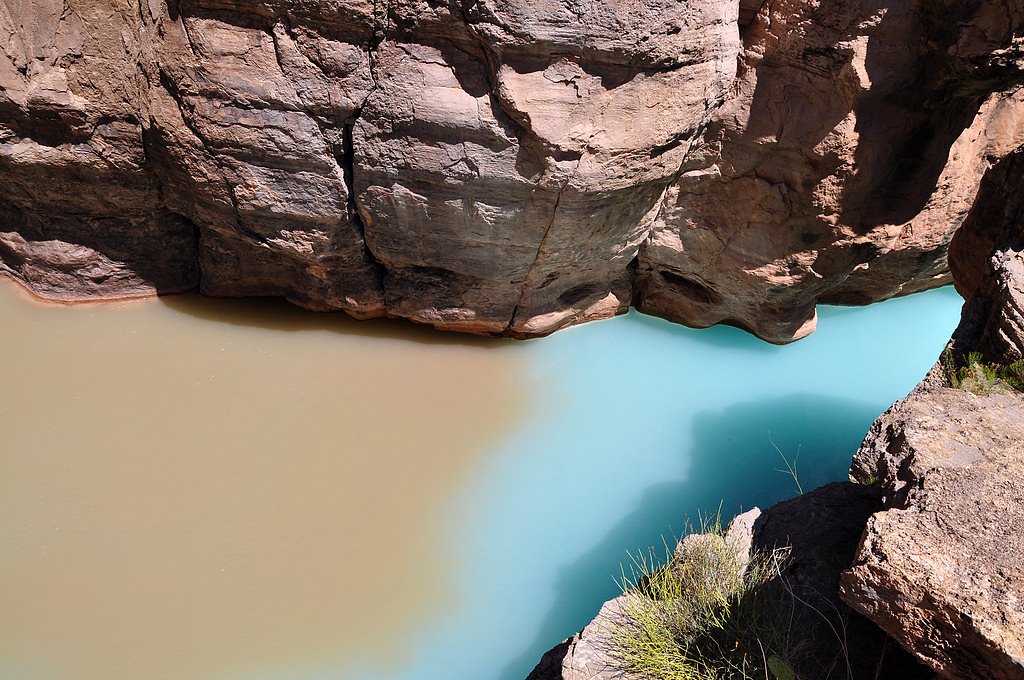
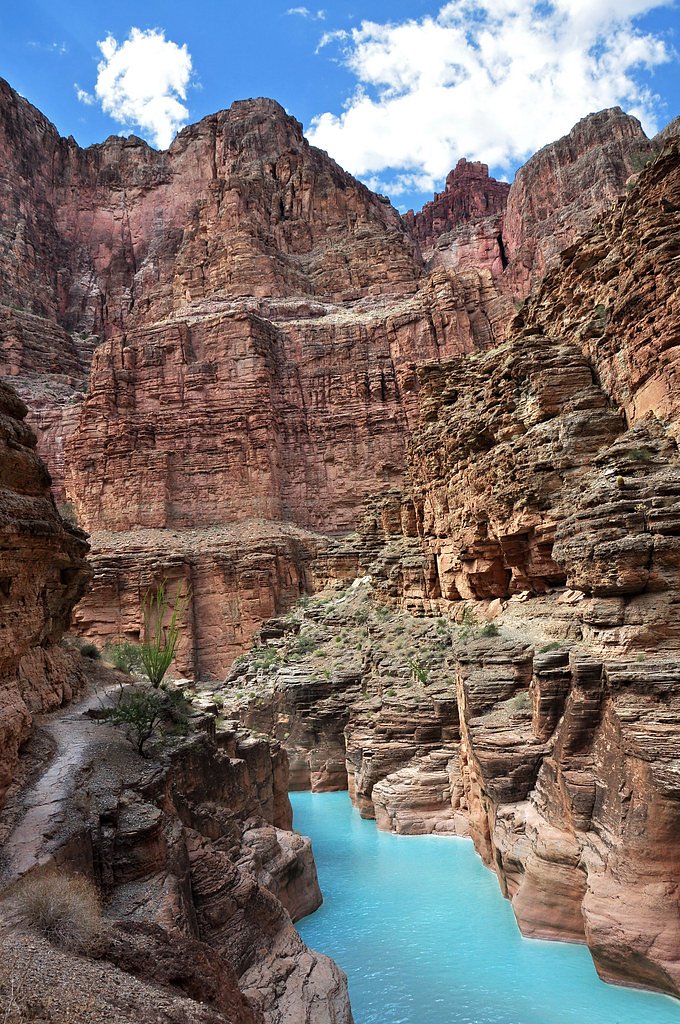
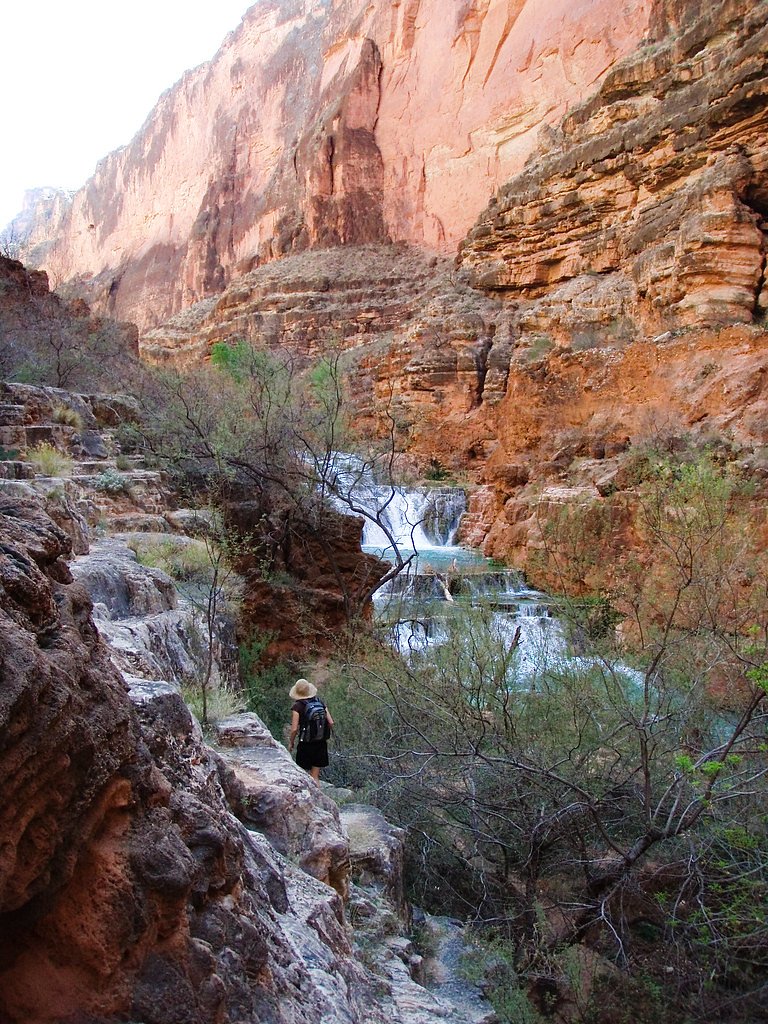
Photo Credits (5)
Difficulty
Moderate
Trail Length
2.4 miles
Trail Type
Out And Back
Elevation Gain
350 ft
About Beaver Falls
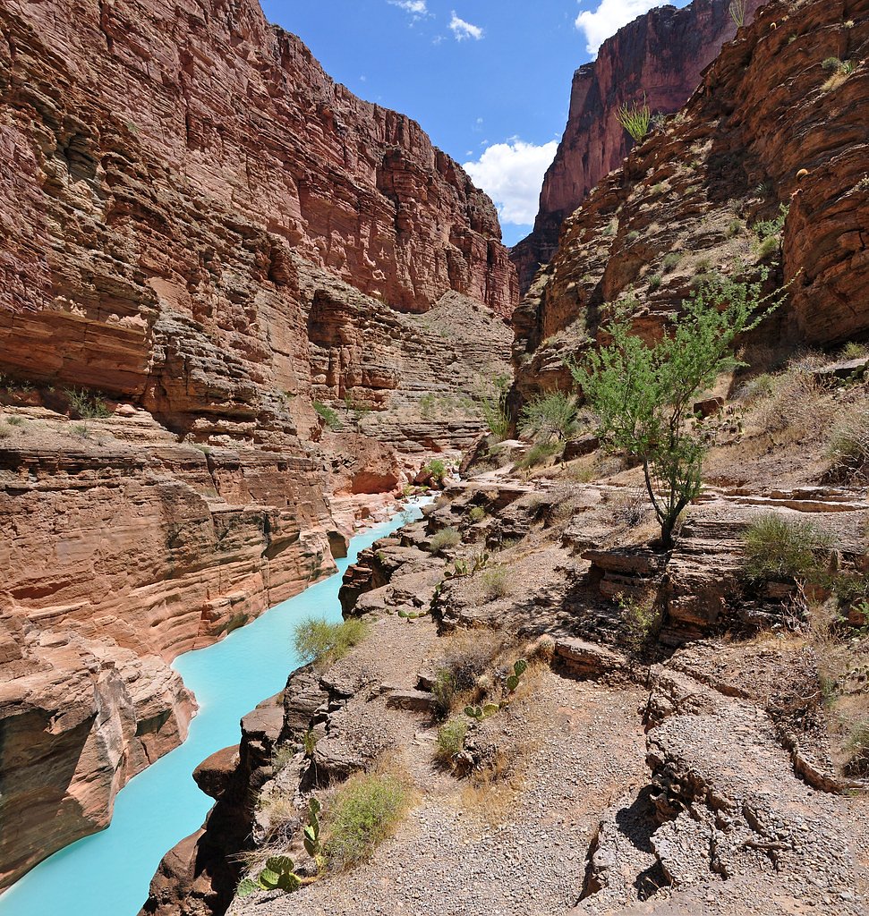
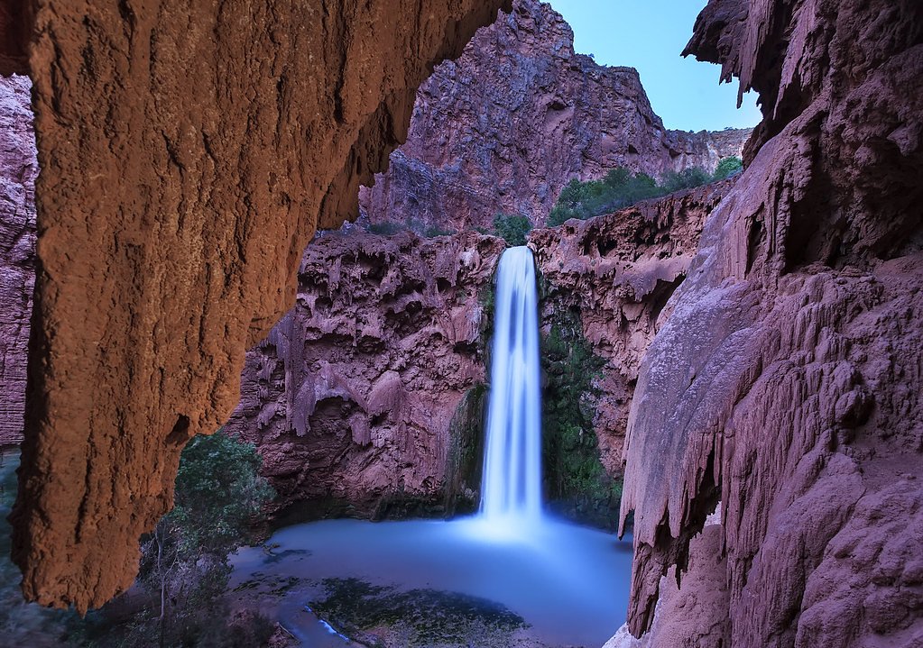
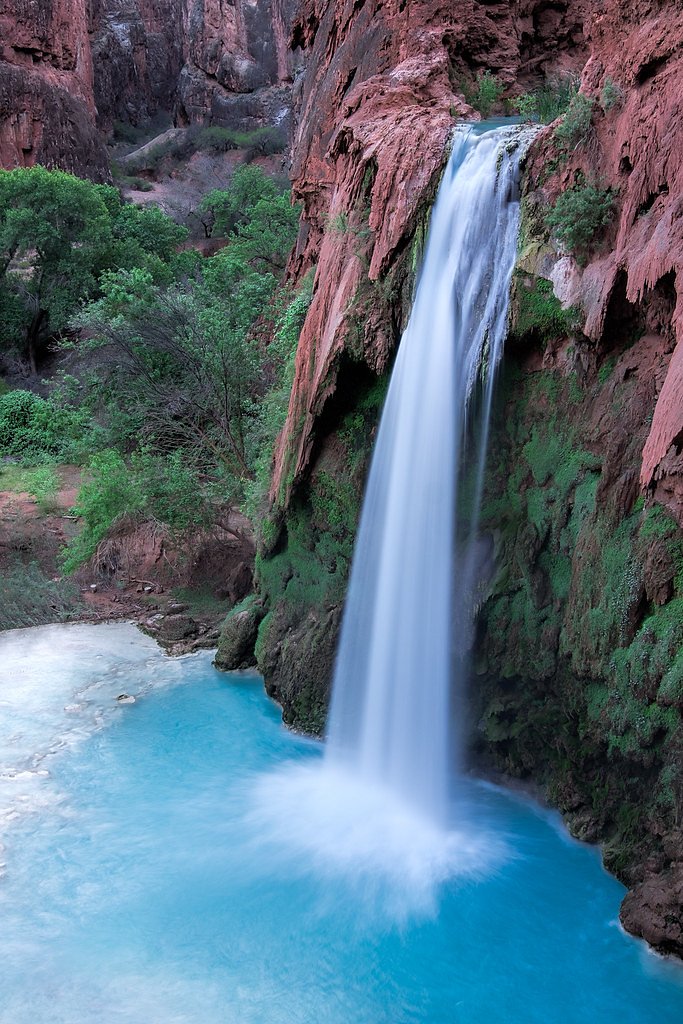
Beaver Falls is a striking run of cascades and turquoise pools on Havasu Creek, set within the Havasupai Reservation. The falls are framed by red canyon walls and lush riparian pockets, creating vivid contrasts that make this stretch of creek one of the most photogenic in the region. The site sits on tribal lands (land owner: DESG; designation: TRIBL) managed by Havasupai authorities, so visitors should respect access rules and permits required by the tribe. The falls share the same sparkling blue water that defines other famous Havasu Creek drops — nearby Havasu Falls (Havasupai: Havasuw Hagjahgeevma) is a well-known example of the creek’s scenery and is noted on Wikipedia as a Grand Canyon-area waterfall within Havasupai tribal lands. Beaver Falls rewards hikers with multiple swimming holes and cascade viewpoints, making it a memorable day hike for those prepared for water crossings and rugged canyon terrain.
The Setting
Beaver Falls sits at 2,201 feet within Grand Canyon National Park, fed by the Havasu Creek, in the hills of Arizona.
Nearby Falls Worth Visiting
Mooney Falls (200 ft) lies 1.7 miles to the southeast. Also nearby: Havasu Falls (100 ft, 2.5 mi).
Trail & Hike Details
The Approach
The moderate 2.4-mile out-and-back trail gains 350 feet of elevation on the way to the falls.
Trail Description
The hike to Beaver Falls is an out-and-back route of about 2.4 miles round trip with roughly 350 feet of elevation change; it’s rated moderate. The route leaves the campground area and follows Havasu Creek, requiring multiple creek crossings and short sections of boulder scrambling and ladders. The trail is generally well-marked but can be rugged underfoot and wet where it runs alongside and through the creek, so sturdy footwear and caution at water crossings are advised. Expect a natural, unpaved trail with variable footing rather than a developed surface; the difficulty comes from the creek crossings and uneven terrain rather than technical climbing.
What to Expect
Swimming is permitted.
Accessibility
The trail is not wheelchair accessible. Uneven terrain and elevation changes require steady footing.
Frequently Asked Questions
🐶 Are Dogs Allowed at Beaver Falls?
❌ Dogs are not allowed
Are There Any Fees or Permits Required?
🤑 Fee: $0.00
Permit required
Permits are required to enter the Havasupai Reservation and must be obtained in advance through the official Havasupai Tribe website. Permits often sell out months in advance.
🏊 Is There Swimming at Beaver Falls?
✅ Swimming is allowed
When to Visit
Spring and fall are the best times to visit due to milder temperatures. Summer can be very hot, and winter may bring cooler temperatures and icy conditions.
Seasonal Access
The best time to visit is Spring, Summer, and Fall. Winter access may be limited. Watch for flash flood warnings during monsoon season (July through September). Check with Grand Canyon National Park for current conditions.
Safety Information
The trail involves steep sections, ladders, and water crossings, which can be hazardous. Flash floods are a risk, especially during monsoon season. Always check weather conditions before your trip.
Current Water Conditions
68 ft³/s
Current discharge — how much water is flowing
About average for this time of year
7.00 ft
Water depth at gauge
7-Day Discharge Trend
What does this mean for your visit?
Flow is about average for this time of year.
About This Gauge
7-Day Flow Outlook
Based on the USGS gauge HAVASU CREEK ABOVE THE MOUTH, NEAR SUPAI, AZ (4 km away).
Today
Moderate
66 cfs
8/10Tomorrow
Moderate
66 cfs
8/10Tue
Moderate
66 cfs
8/10Wed
Moderate
66 cfs
8/10Thu
Moderate
66 cfs
8/10Fri
Moderate
66 cfs
8/10Sat
Moderate
66 cfs
8/10Best window: Today — moderate flow, sunny (trip score 8/10).
Best time of year: this gauge typically runs highest from early March to late March, peaking in August.
How we calculate this
This is a transparent outlook, not a precise forecast. We take the waterfall's current flow strength (how it ranks against its historical normal for today, from the nearest USGS stream gauge), carry that ranking forward along the gauge's seasonal curve, and nudge it for forecast rain. Confidence is highest for the next day or two and falls further out. Always check official conditions and your own judgment before visiting — high flows can be dangerous.
Know when to go.
Get a free email alert when waterfalls near Kaibab hit peak flow. We only send when conditions are worth the trip — no weekly newsletters, no spam.
Weather Forecast
Location & Access
Getting There
Beaver Falls is accessible via a hike from the Havasupai Campground, which itself requires a 10-mile hike from the Hualapai Hilltop trailhead. Visitors must first obtain a permit to enter the Havasupai Reservation.
Get Directions on Google MapsParking
Parking is available at the Hualapai Hilltop trailhead, which serves as the starting point for the hike to the falls.
Elevation
2,201 feet above sea level
Coordinates
36.281338° N, -112.729783° W
Land Management
Managed by TRIB
Visitor Tips & Gear
Wear sturdy, water-resistant hiking shoes as the trail involves water crossings. Bring plenty of water, snacks, and sunscreen. Be prepared for a long hike and ensure you have a valid permit before arriving.
As an Amazon Associate, we earn from qualifying purchases.
With 2.4 miles and 350 ft of elevation gain, sturdy boots and trekking poles will help on this moderate trail. Sun exposure on the trail makes good sun protection a must in summer.

Polarized Sunglasses (Knockaround)
Cuts glare off the water so you actually see the falls — and your photos turn out better too.

Columbia Watertight II Rain Jacket
Packs into its own pocket, seam-sealed, and keeps you dry from spray and surprise rain.

Earth Pak Waterproof Dry Bag
Keeps your phone and gear dry when waterfall mist soaks everything else.

Waterproof Phone Pouch (AiRunTech)
Cheap insurance — take photos right next to the falls without killing your phone.

Timberland Euro Sprint Mid Waterproof
Trusted waterproof boot with premium leather and grippy rubber sole — reliable on rocky, wet trails.

TrailBuddy Trekking Poles
Lightweight aluminum, cork grips, and flip-locks that actually hold — a best-seller for good reason.
Where to Stay
Browse vacation cabins and private rentals nearby
Unique outdoor stays — tents, yurts, and treehouses
Rent a campervan or RV for your waterfall road trip
Some links are affiliate links. We may earn a commission at no extra cost to you.
Nearby Campground
JUMPUP CABIN
23.3 miles away · 1 sites
Overview Since the 1900s, Jumpup cabin has been used by ranchers as well as the Forest Service, and is listed on the National Register of Historic Places. The site consists of a historic two-room cabin, shed and composting toilet. Recreation Jumpup cabin is located at the trailhead for the Ranger trail, a 17-mile wilderness trail that winds through Kanab Creek. Hiking this area is very popular in the spring and fall months, but is discouraged during the hottest summer months. Water is scarce and
Book on Recreation.govNearby Hot Springs
Hot springs near Kaibab, Arizona

Lava Warm Springs
Lava Warm Springs flows at 90°F on the Hualapai Indian Reservation in Mohave County near Peach Springs, emerging 20 degrees war...
Pumpkin Spring
Pumpkin Spring emerges as a mineralized thermal feature in the Grand Canyon's depths, located on the Hualapai Indian Reservatio...
Colorado Pool
Colorado Pool flows at 86 degrees Fahrenheit near the Grand Canyon in Coconino County at 2,912 feet elevation, requiring approx...
Looking for a soak after your hike? Explore more hot springs near Kaibab, Arizona on SoakingSprings.
Explore Arizona springsAdditional Information
Nearby Attractions
Other waterfalls in the area include Havasu Falls, Mooney Falls, and Navajo Falls.
Wildlife
The area is home to various desert wildlife, including birds, lizards, and small mammals. Be cautious of snakes and other potentially dangerous animals.
Cities near Beaver Falls
Nearby Waterfalls
Other waterfalls named Beaver Falls
6 other waterfalls share this name across the U.S.
Writing about Beaver Falls? Embed this waterfall on your site for free.