
Photo Credits (5)
Difficulty
Easy
Trail Length
1.2 miles
Trail Type
Out And Back
Elevation Gain
200 ft
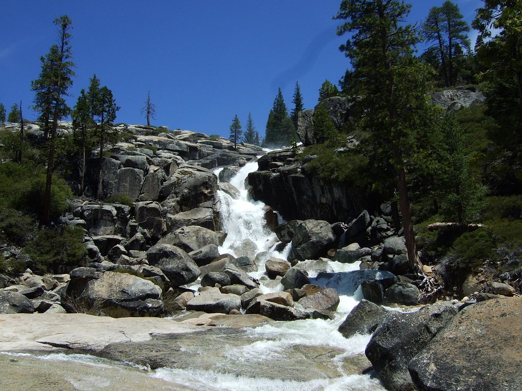
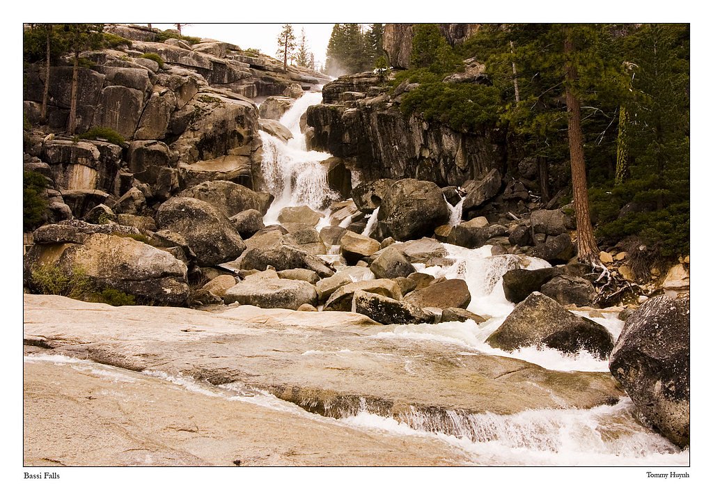
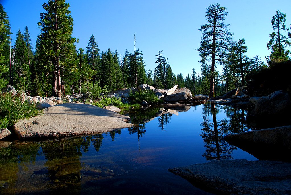
About Bassi Falls
Bassi Falls is a stunning 109-foot waterfall located in the Eldorado National Forest in California. It is known for its wide cascade over granite rocks, especially impressive during spring and early summer when snowmelt is at its peak.
The Setting
Bassi Falls sits at 5,476 feet within Eldorado National Forest, in the high mountains of California. At 109 feet, it is among the taller waterfalls in California.
Height: 109 feet
Trail & Hike Details
The Approach
The easy hike follows Bassi Falls (#15E10), a 1.2-mile out-and-back trail over natural surface. Expect 200 feet of elevation gain with grades of 10-12%. The trail is developed (Class 3).
USFS Trail
BASSI FALLS #15E10
Trail Class
Developed
Surface
Avg Grade
USFS Segment
0.03 miTrail Description
The trail to Bassi Falls is a short and relatively easy hike through a forested area with some rocky sections. It is well-marked and leads directly to the base of the waterfall, offering excellent views along the way.
What to Expect
The falls cascade 109 feet. Swimming is permitted. Dogs are welcome.
Accessibility
The trail is not wheelchair accessible. Uneven terrain and elevation changes require steady footing.
Frequently Asked Questions
🐶 Are Dogs Allowed at Bassi Falls?
✅ Dogs are allowed
Are There Any Fees or Permits Required?
🆖 No fees required
🏊 Is There Swimming at Bassi Falls?
✅ Swimming is allowed
When to Visit
The best time to visit Bassi Falls is in late spring or early summer when the snowmelt creates a powerful flow. By late summer, the flow may diminish significantly.
Seasonal Access
The best time to visit is Spring and Summer. Access roads and trails may close during winter due to snow. Check with Eldorado National Forest for seasonal road closures.
Safety Information
Rocks near the falls can be slippery, especially when wet. Exercise caution and supervise children closely. Be aware of changing weather conditions, as storms can occur unexpectedly.
Know when to go.
Get a free email alert when waterfalls near Meyers hit peak flow. We only send when conditions are worth the trip — no weekly newsletters, no spam.
Weather Forecast
Location & Access
Getting There
Bassi Falls is located off Ice House Road in the Eldorado National Forest. From Highway 50, take Ice House Road and follow signs to the trailhead. The last portion of the road may be rough and unpaved, so a high-clearance vehicle is recommended.
Get Directions on Google MapsParking
There is a small parking area near the trailhead, but it can fill up quickly during peak seasons. Arrive early to secure a spot.
Elevation
5,476 feet above sea level
Coordinates
38.892609° N, -120.330297° W
Land Management
Managed by USFS
Visitor Tips & Gear
Visit in the morning to avoid crowds and ensure parking availability. Bring plenty of water and sunscreen, as parts of the trail are exposed. Be cautious on the rocks near the falls, as they can be slippery.
This trail sits at 5,476 ft above sea level
Elevated TrailUV radiation is roughly 22% stronger at this elevation than at sea level, and the dry air accelerates dehydration. Extra sun protection and fluids go a long way.
As an Amazon Associate, we earn from qualifying purchases.

Coppertone Sport SPF 50 Sunscreen
UV intensity jumps ~4% per 1,000 ft — at this elevation you can burn in half the time.

Sun Bum SPF 30 Lip Balm (3-Pack)
Lips have almost no natural UV protection and burn fast in thin, dry mountain air.

Liquid I.V. Electrolyte Packets
You lose moisture ~2x faster at elevation — electrolytes help you absorb water efficiently.

ROCKNIGHT Polarized UV400 Sunglasses
High-altitude glare off rock and water is intense — UV400 lenses block 99%+ of UVA/UVB.
As an Amazon Associate, we earn from qualifying purchases.
This easy 1.2 miles hike is straightforward — comfortable trail shoes and plenty of water should do. Sun exposure on the trail makes good sun protection a must in summer.

Polarized Sunglasses (Knockaround)
Cuts glare off the water so you actually see the falls — and your photos turn out better too.

Columbia Watertight II Rain Jacket
Packs into its own pocket, seam-sealed, and keeps you dry from spray and surprise rain.

Earth Pak Waterproof Dry Bag
Keeps your phone and gear dry when waterfall mist soaks everything else.

Waterproof Phone Pouch (AiRunTech)
Cheap insurance — take photos right next to the falls without killing your phone.

JOBY GorillaPod Starter Kit
Wraps around railings and rocks for long-exposure waterfall shots — no flat surface needed.

Osprey Daylite Daypack
Light, organized, and just the right size for a day hike — fits water, snacks, and layers.
Where to Stay

HiMark Hotel

Station House Inn South Lake Tahoe

Tahoe Lakeshore Lodge & Spa

Sunnyside Resort and Lodge
Browse vacation cabins and private rentals nearby
Unique outdoor stays — tents, yurts, and treehouses
Rent a campervan or RV for your waterfall road trip
Some links are affiliate links. We may earn a commission at no extra cost to you.
Nearby Campground
BIG SILVER GROUP
2 miles away · 1 sites
Overview Big Silver Group Campground offers tent and RV camping for up to 50 guests. The campground is located 23 miles east of Placerville on Highway 50 and 16 miles north on Ice House Road, east of nearby Union Valley Reservoir.Recreation Visitors may enjoy forest-lined scenic views and recreation opportunities, such as, hiking, fishing, biking, wildlife viewing and migratory bird spotting. The campground has immediate access to the Union Valley Bike Trail; an easy 5.8 mile, two-lane bikeway wi
Book on Recreation.govNearby Hot Springs
Hot springs near Meyers, California
Myers Warm Spring
Myers Warm Spring flows at 75°F (24°C) near South Lake Tahoe at an elevation of 7,615 feet—one of California's highest-elevatio...
Walleys Hot Springs
Walleys Hot Springs flows at 160°F in Douglas County at 4,690 feet elevation, positioned just 20 meters from the roadside near ...

Brockway Hot Springs
Brockway Hot Springs surges at 131°F directly into Lake Tahoe's frigid waters at 6,337 feet elevation near Kings Beach. Located...
Hobo Hot Springs
Hobo Hot Springs flows at 114 degrees Fahrenheit on Stewart Community tribal land in Douglas County at 4,760 feet elevation, po...

Grovers Hot Springs
Grovers Hot Springs emerges at a powerful 147 degrees Fahrenheit in Toiyabe National Forest, displaying a remarkable 100-degree...
Grover Hot Springs State Park
Grover Hot Springs State Park operates a developed pool complex fed by natural thermal waters at 5,921 feet elevation in Dougla...
Looking for a soak after your hike? Explore more hot springs near Meyers, California on SoakingSprings.
Explore California springsAdditional Information
Nearby Attractions
Ice House Reservoir, Union Valley Reservoir, and other hiking trails in the Eldorado National Forest.
Wildlife
The area is home to various wildlife, including deer, squirrels, and a variety of birds. Be cautious of ticks and other insects.
Cities near Bassi Falls
Writing about Bassi Falls? Embed this waterfall on your site for free.