Awbrey Falls
By Armen Suny · Last verified May 2026

Photo Credits (1)
Difficulty
Moderate
Trail Length
2.0 miles
Trail Type
Out And Back
Elevation Gain
300 ft
About Awbrey Falls
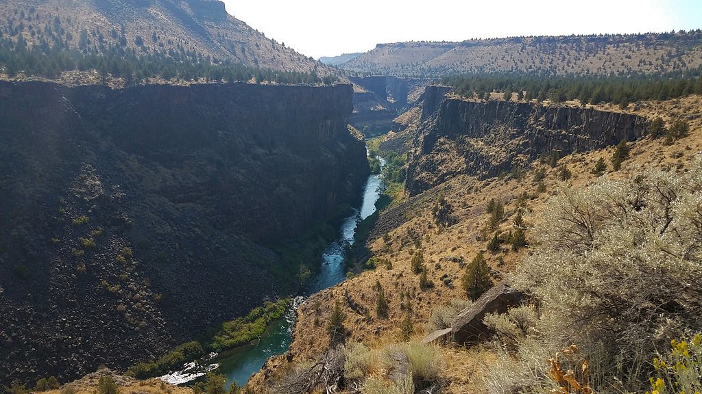
Awbrey Falls sits on the Deschutes River in Deschutes County, Oregon, and delivers a compact but striking cascade that pours over lava-formed rock into the river below. The falls are best known for a long lava tube running beneath the curtain of water—a vivid clue to the region’s volcanic past that draws photographers and geology-minded hikers. The site has a tucked-away feel rather than a touristy atmosphere, making it a peaceful short outing for walkers, photographers, and river-watchers who want a strong geological payoff without a long trek. Visitors arrive via a short trail (about 2.0 miles round-trip with roughly 300 feet of elevation gain) that most parties complete as a half- or full-day excursion. Paddlers should exercise extreme caution: there is a mandatory portage on the right, and the main channel above the falls is hazardous—do not approach it because of the high current over the drop. There aren’t developed campgrounds at the trailhead; the nearest maintained campsite is Reynolds Pond Recreation Site, roughly 26.8 km away, so plan accordingly and bring day-trip provisions or reserve camping elsewhere in Deschutes County before you come.
The Setting
Awbrey Falls sits at 3,058 feet along the Crooked River, in the mountains of Oregon.
Trail & Hike Details
The Approach
The moderate 2.0-mile out-and-back trail gains 300 feet of elevation on the way to the falls.
Trail Description
Trail type: out-and-back. Length: 2.0 miles round trip. Elevation gain: approximately 300 feet. Difficulty: moderate. The trail descends to a Deschutes River viewpoint where Awbrey Falls drops over lava-formed rock and reveals a notable lava tube beneath the cascade. Expect a short but steady climb totaling about 300 feet of ascent on the out-and-back route; footing can be uneven near viewpoints where rock and roots are common. U.S. Forest Service surface, grade, and official trail class data are not provided in the supplied records. River users must portage on the right and avoid the main channel above the falls due to strong currents.
What to Expect
Visitors can expect a tranquil waterfall surrounded by natural beauty. The area is relatively secluded, making it a great spot for those looking to escape crowds. However, trail conditions may vary depending on the season, so preparation is key.
Accessibility
The trail is not wheelchair accessible. Uneven terrain and elevation changes require steady footing.
Frequently Asked Questions
🐶 Are Dogs Allowed at Awbrey Falls?
❌ Dogs are not allowed
Are There Any Fees or Permits Required?
🆖 No fees required
🏊 Is There Swimming at Awbrey Falls?
❌ Swimming is not allowed
When to Visit
Spring and early summer are ideal times to visit, as the waterfall flow is typically strongest due to snowmelt and seasonal rains.
Seasonal Access
The best time to visit is Spring, Summer, and Fall. Winter access may be limited.
Safety Information
Visitors should be cautious of slippery rocks near the waterfall and be prepared for changing weather conditions. Carry a first aid kit and let someone know your plans before heading out.
Current Water Conditions
Based on a USGS gauge 16.3 miles away
88 ft³/s
Current discharge — how much water is flowing
Much lower than usual for this time of year
Based on 22 years of record
1.65 ft
Water depth at gauge
7-Day Discharge Trend
What does this mean for your visit?
Flow is well below normal for this time of year, so the waterfall may be a trickle.
About This Gauge
This gauge is on a regional waterway. Conditions at the falls may differ, especially after local rain.
7-Day Flow Outlook
Based on the USGS gauge CROOKED RIVER BLW OSBORNE CANYON, NR OPAL CITY, OR (26 km away).
Today
Barely Flowing
88 cfs
5/10Tomorrow
Barely Flowing
85 cfs
5/10Fri
Barely Flowing
90 cfs
3/10Sat
Low
103 cfs
3/10Sun
Barely Flowing
94 cfs
5/10Mon
Barely Flowing
85 cfs
5/10Tue
Barely Flowing
89 cfs
5/10Best window: Today — barely flowing flow, mostly sunny (trip score 5/10).
Best time of year: this gauge typically runs highest from mid March to mid May, peaking in April.
How we calculate this
This is a transparent outlook, not a precise forecast. We take the waterfall's current flow strength (how it ranks against its historical normal for today, from the nearest USGS stream gauge), carry that ranking forward along the gauge's seasonal curve, and nudge it for forecast rain. Confidence is highest for the next day or two and falls further out. Always check official conditions and your own judgment before visiting — high flows can be dangerous.
Know when to go.
Get a free email alert when waterfalls near Tumalo hit peak flow. We only send when conditions are worth the trip — no weekly newsletters, no spam.
Weather Forecast
Location & Access
Getting There
Awbrey Falls is located in a remote area of Oregon. Access typically requires driving on forest roads, which may be unpaved or rough in some sections. Visitors should check local maps and conditions before heading out.
Get Directions on Google MapsParking
Parking availability is limited and may consist of small pullouts along the road near the trailhead. Visitors should plan accordingly.
Elevation
3,058 feet above sea level
Coordinates
44.194629° N, -121.294306° W
Visitor Tips & Gear
Bring plenty of water, wear sturdy hiking shoes, and check weather and trail conditions before your visit. Cell service may be limited in the area, so download maps or directions in advance.
As an Amazon Associate, we earn from qualifying purchases.
With 2.0 miles and 300 ft of elevation gain, sturdy boots and trekking poles will help on this moderate trail. Sun exposure on the trail makes good sun protection a must in summer.

Polarized Sunglasses (Knockaround)
Cuts glare off the water so you actually see the falls — and your photos turn out better too.

Columbia Watertight II Rain Jacket
Packs into its own pocket, seam-sealed, and keeps you dry from spray and surprise rain.

Earth Pak Waterproof Dry Bag
Keeps your phone and gear dry when waterfall mist soaks everything else.

Waterproof Phone Pouch (AiRunTech)
Cheap insurance — take photos right next to the falls without killing your phone.

Timberland Euro Sprint Mid Waterproof
Trusted waterproof boot with premium leather and grippy rubber sole — reliable on rocky, wet trails.

TrailBuddy Trekking Poles
Lightweight aluminum, cork grips, and flip-locks that actually hold — a best-seller for good reason.
Where to Stay

Eagle Creek Chalet on the Pond

Eagle Crest

Canyon Rim at Eagle Crest

Eagle Crest Escape
Browse vacation cabins and private rentals nearby
Unique outdoor stays — tents, yurts, and treehouses
Rent a campervan or RV for your waterfall road trip
Some links are affiliate links. We may earn a commission at no extra cost to you.
Nearby Campground
Reynolds Pond Recreation Site
16.7 miles away · 0 sites
An oasis sits just east of Bend...a small 12-acre pond surrounded by old juniper and dusty trails. Tall willow and cattails offer a lush green vista in a sea of desert brown. Visitors can pass through to access the north side of the Oregon Badlands Wilderness or spend the day at the pond, enjoying the sunshine and fishing for sunfish, largemouth bass and brown bullheads. The .75 mile walking trail around the pond provides access to spots for picnicking and floating. Bring a tent and tuck yourself
Book on Recreation.govNearby Hot Springs
Hot springs near Tumalo, Oregon
Paulina Springs
Paulina Springs emerges at 70°F within Newberry National Volcanic Monument in Deschutes County, flowing at 6,338 feet elevation...

East Lake Hot Springs
East Lake Hot Springs emerges at 144°F on the shore of East Lake within the Newberry Volcano caldera, flowing 103.8°F above the...
Belknap Springs
Belknap Springs flows at 160°F along the McKenzie River in the Cascade Range, emerging just 510 feet from North Belknap Springs...

Bigelow Hot Springs
Bigelow Hot Springs, also called Deer Creek Hot Springs, emerges at 142°F just 400 feet from Deer Creek Road in the Willamette ...

Springs
These thermal springs emerge at 125°F on sovereign Warm Springs Reservation land in Jefferson County, creating a 72-degree temp...
Foley Springs
Foley Springs emerges at 178°F in the Cascade Range of Lane County, making it one of Oregon's hottest thermal features with rec...
Looking for a soak after your hike? Explore more hot springs near Tumalo, Oregon on SoakingSprings.
Explore Oregon springsAdditional Information
Nearby Attractions
Other nearby attractions may include additional waterfalls, hiking trails, and scenic viewpoints in the surrounding forest.
Wildlife
The area is home to a variety of wildlife, including birds, deer, and small mammals. Visitors should be cautious and respectful of the natural habitat.
Cities near Awbrey Falls
Nearby Waterfalls

Writing about Awbrey Falls? Embed this waterfall on your site for free.