Austin Stream Falls
By Armen Suny · Last verified May 2026
Difficulty
Moderate
Trail Length
2.4 miles
Trail Type
Out And Back
Elevation Gain
350 ft
About Austin Stream Falls
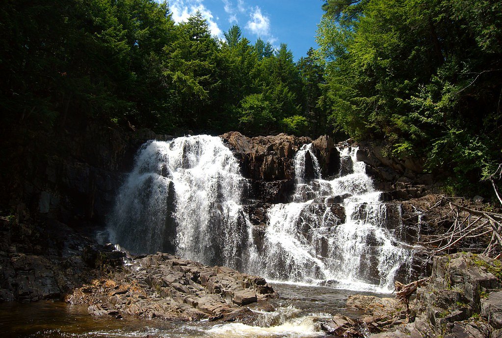
Austin Stream Falls is a scenic waterfall located in Maine, known for its natural beauty and tranquil surroundings. It is a lesser-known destination, making it a peaceful spot for visitors seeking solitude in nature.
The Setting
Austin Stream Falls sits at 899 feet along the Austin Stream, in the foothills of Maine.
Nearby Falls Worth Visiting
Houston Brook Falls (32 ft) lies 7.5 miles to the southwest.
Trail & Hike Details
The Approach
The moderate 2.4-mile out-and-back trail gains 350 feet of elevation on the way to the falls.
Trail Description
The trail to Austin Stream Falls is relatively short and easy, making it suitable for most visitors. It passes through a forested area and may involve some uneven terrain. The trail leads to a picturesque view of the falls, which cascade over rocks into a serene pool below.
What to Expect
Dogs are welcome.
Accessibility
The trail is not wheelchair accessible. Uneven terrain and elevation changes require steady footing.
Frequently Asked Questions
🐶 Are Dogs Allowed at Austin Stream Falls?
✅ Dogs are allowed
Are There Any Fees or Permits Required?
🆖 No fees required
🏊 Is There Swimming at Austin Stream Falls?
❌ Swimming is not allowed
When to Visit
Spring and early summer are ideal times to visit, as the water flow is typically strongest due to snowmelt and rainfall.
Seasonal Access
The best time to visit is Spring, Summer, and Fall. Winter access may be limited.
Safety Information
Be cautious of slippery rocks near the falls, especially after rain. During winter, ice and snow can make the trail hazardous. Always stay on marked trails and avoid getting too close to the edge of the falls.
Current Water Conditions
86 ft³/s
Current discharge — how much water is flowing
About average for this time of year
Based on 55 years of record
4.06 ft
Water depth at gauge
7-Day Discharge Trend
What does this mean for your visit?
Flow is about average for this time of year.
About This Gauge
This gauge is on a nearby waterway and may not reflect exact conditions at the falls.
7-Day Flow Outlook
Based on the USGS gauge Austin Stream at Bingham, Maine (9 km away).
Today
Low
86 cfs
6/10Tomorrow
Low
89 cfs
6/10Tue
Moderate
83 cfs
5/10Wed
Moderate
88 cfs
4/10Thu
Moderate
83 cfs
5/10Fri
Moderate
75 cfs
4/10Sat
Moderate
67 cfs
5/10Best window: Today — low flow, mostly sunny (trip score 6/10).
Best time of year: this gauge typically runs highest from late March to early June, peaking in April.
How we calculate this
This is a transparent outlook, not a precise forecast. We take the waterfall's current flow strength (how it ranks against its historical normal for today, from the nearest USGS stream gauge), carry that ranking forward along the gauge's seasonal curve, and nudge it for forecast rain. Confidence is highest for the next day or two and falls further out. Always check official conditions and your own judgment before visiting — high flows can be dangerous.
Know when to go.
Get a free email alert when waterfalls near North Anson hit peak flow. We only send when conditions are worth the trip — no weekly newsletters, no spam.
Weather Forecast
Location & Access
Getting There
Austin Stream Falls is located near Bingham, Maine. Access typically involves driving on rural roads, and visitors should consult local maps or GPS for precise directions.
Get Directions on Google MapsParking
Parking availability is limited and may consist of roadside pull-offs or small informal parking areas near the trailhead.
Elevation
899 feet above sea level
Coordinates
45.131999° N, -69.813391° W
Visitor Tips & Gear
Wear sturdy footwear, as the trail may be uneven in places. Bring insect repellent during warmer months, and check weather conditions before visiting, especially in winter when snow or ice may make access more difficult.
As an Amazon Associate, we earn from qualifying purchases.
With 2.4 miles and 350 ft of elevation gain, sturdy boots and trekking poles will help on this moderate trail. Sun exposure on the trail makes good sun protection a must in summer.

Columbia Watertight II Rain Jacket
Packs into its own pocket, seam-sealed, and keeps you dry from spray and surprise rain.

Earth Pak Waterproof Dry Bag
Keeps your phone and gear dry when waterfall mist soaks everything else.

Waterproof Phone Pouch (AiRunTech)
Cheap insurance — take photos right next to the falls without killing your phone.

Timberland Euro Sprint Mid Waterproof
Trusted waterproof boot with premium leather and grippy rubber sole — reliable on rocky, wet trails.

TrailBuddy Trekking Poles
Lightweight aluminum, cork grips, and flip-locks that actually hold — a best-seller for good reason.

Polarized Sunglasses (Knockaround)
Cuts glare off the water so you actually see the falls — and your photos turn out better too.
Where to Stay

The Sterling Inn

Mountain-View Maine Cabin: Ski, Hike & Bike!

Abbot Trailside Lodging

Bingham Motor Inn
Browse vacation cabins and private rentals nearby
Unique outdoor stays — tents, yurts, and treehouses
Rent a campervan or RV for your waterfall road trip
Some links are affiliate links. We may earn a commission at no extra cost to you.
Additional Information
Nearby Attractions
The town of Bingham offers additional outdoor activities, including hiking and fishing opportunities. The Kennebec River is also nearby.
Wildlife
The area is home to a variety of wildlife, including birds, deer, and small mammals. Visitors should be mindful of their surroundings and avoid disturbing the natural habitat.
Cities near Austin Stream Falls
Nearby Waterfalls
Writing about Austin Stream Falls? Embed this waterfall on your site for free.