Allagash Falls
Maine • 40 ft
By Armen Suny · Last verified Mar 2026
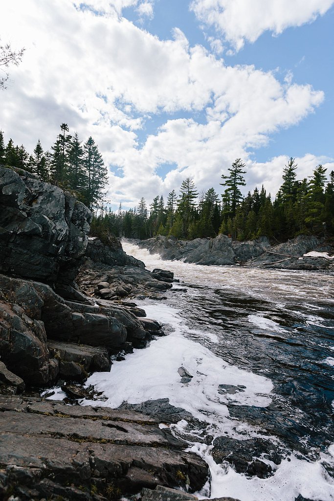
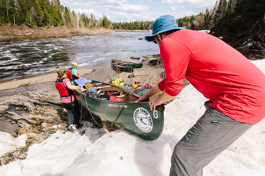


Photo Credits (5)
Difficulty
Moderate
Trail Length
2.4 miles
Trail Type
Out And Back
Elevation Gain
350 ft
About Allagash Falls
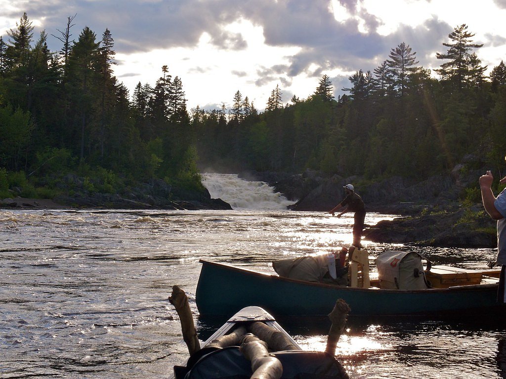
Allagash Falls is a scenic waterfall located along the Allagash Wilderness Waterway in northern Maine. It is a remote and serene destination, offering visitors a chance to experience the beauty of Maine's wilderness. The falls are approximately 40 feet high and cascade over a series of rocky ledges.
The Setting
Allagash Falls sits at 679 feet along the Allagash River, in the foothills of Maine. The falls drop 40 feet.
Height: 40 feet
Trail & Hike Details
The Approach
The moderate 2.4-mile out-and-back trail gains 350 feet of elevation on the way to the falls.
Trail Description
The trail to Allagash Falls is a short, unmarked path from the riverbank to the falls. It is relatively flat but may have uneven terrain due to rocks and roots. Visitors should wear sturdy footwear and be prepared for a wilderness setting.
What to Expect
The falls drop 40 feet. Dogs are welcome.
Accessibility
The trail is not wheelchair accessible. Uneven terrain and elevation changes require steady footing.
Frequently Asked Questions
🐶 Are Dogs Allowed at Allagash Falls?
✅ Dogs are allowed
Are There Any Fees or Permits Required?
🤑 Fee: $0.00
Permit required
Permits are required for overnight camping along the Allagash Wilderness Waterway. Contact the Maine Bureau of Parks and Lands for more information.
🏊 Is There Swimming at Allagash Falls?
❌ Swimming is not allowed
When to Visit
The best time to visit is during late spring, summer, or early fall when the weather is mild, and the river conditions are favorable for paddling.
Seasonal Access
The best time to visit is Spring, Summer, and Fall. Winter access may be limited.
Safety Information
Exercise caution near the falls, as the rocks can be slippery, and the currents are strong. Be prepared for wilderness conditions, and carry a first aid kit. Let someone know your travel plans if visiting the area.
Current Water Conditions
1,970 ft³/s
Current discharge — how much water is flowing
Lower than usual for this time of year
Based on 94 years of record
3.67 ft
Water depth at gauge
56°F
ColdBracing — limit time in water
7-Day Discharge Trend
What does this mean for your visit?
Flow is lower than usual for this time of year. Water temperature is a bracing 56 degrees F, limit your time in the water.
About This Gauge
This gauge is on a nearby waterway and may not reflect exact conditions at the falls.
Know when to go.
Get a free email alert when waterfalls near Grand Isle hit peak flow. We only send when conditions are worth the trip — no weekly newsletters, no spam.
Weather Forecast
Location & Access
Getting There
Allagash Falls is accessible via the Allagash Wilderness Waterway, typically by canoe or kayak. The falls are located near the Allagash River, and visitors often reach the area as part of a multi-day paddling trip. There is no direct road access to the falls.
Get Directions on Google MapsParking
Parking is available at designated access points along the Allagash Wilderness Waterway, such as Churchill Dam or Umsaskis Lake, but visitors must paddle to reach the falls.
Elevation
679 feet above sea level
Coordinates
46.950036° N, -69.133098° W
Visitor Tips & Gear
Bring a map or GPS device, as the area is remote and cell service is limited. Be prepared for wilderness conditions, including insects and variable weather. If paddling, ensure you have the necessary skills and equipment for the Allagash River.
As an Amazon Associate, we earn from qualifying purchases.
With 2.4 miles and 350 ft of elevation gain, sturdy boots and trekking poles will help on this moderate trail. Sun exposure on the trail makes good sun protection a must in summer.

Polarized Sunglasses (Knockaround)
Cuts glare off the water so you actually see the falls — and your photos turn out better too.

Columbia Watertight II Rain Jacket
Packs into its own pocket, seam-sealed, and keeps you dry from spray and surprise rain.

Earth Pak Waterproof Dry Bag
Keeps your phone and gear dry when waterfall mist soaks everything else.

Waterproof Phone Pouch (AiRunTech)
Cheap insurance — take photos right next to the falls without killing your phone.

Timberland Euro Sprint Mid Waterproof
Trusted waterproof boot with premium leather and grippy rubber sole — reliable on rocky, wet trails.

TrailBuddy Trekking Poles
Lightweight aluminum, cork grips, and flip-locks that actually hold — a best-seller for good reason.
Where to Stay

Spacious Eagle Lake Home w/ Fireplace & Deck

Riverside Retreat

Love Hotels St John River by OYO at Fort Kent ME
Browse vacation cabins and private rentals nearby
Unique outdoor stays — tents, yurts, and treehouses
Rent a campervan or RV for your waterfall road trip
Some links are affiliate links. We may earn a commission at no extra cost to you.
Additional Information
Nearby Attractions
Other points of interest along the Allagash Wilderness Waterway include Umsaskis Lake, Churchill Dam, and Eagle Lake.
Wildlife
The area is home to a variety of wildlife, including moose, deer, beavers, and numerous bird species.
Cities near Allagash Falls
Writing about Allagash Falls? Embed this waterfall on your site for free.