Alamere Falls
California • 40 ft
By Armen Suny · Last verified Mar 2026
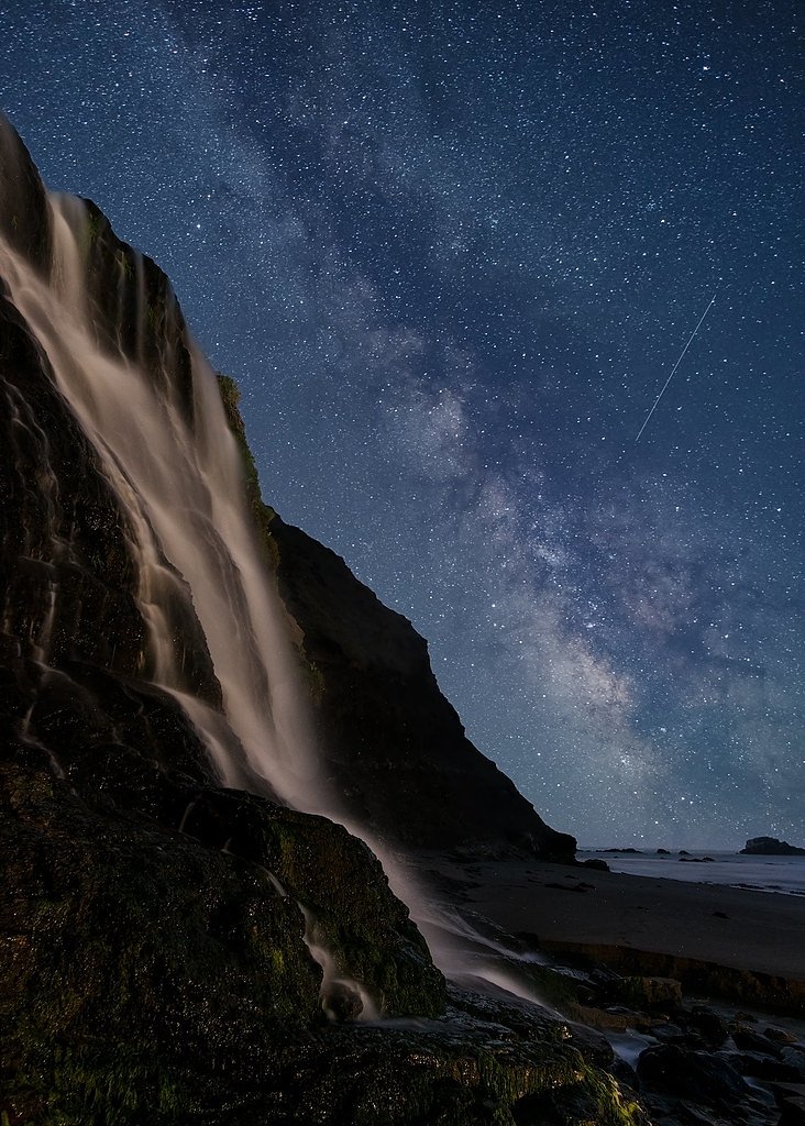
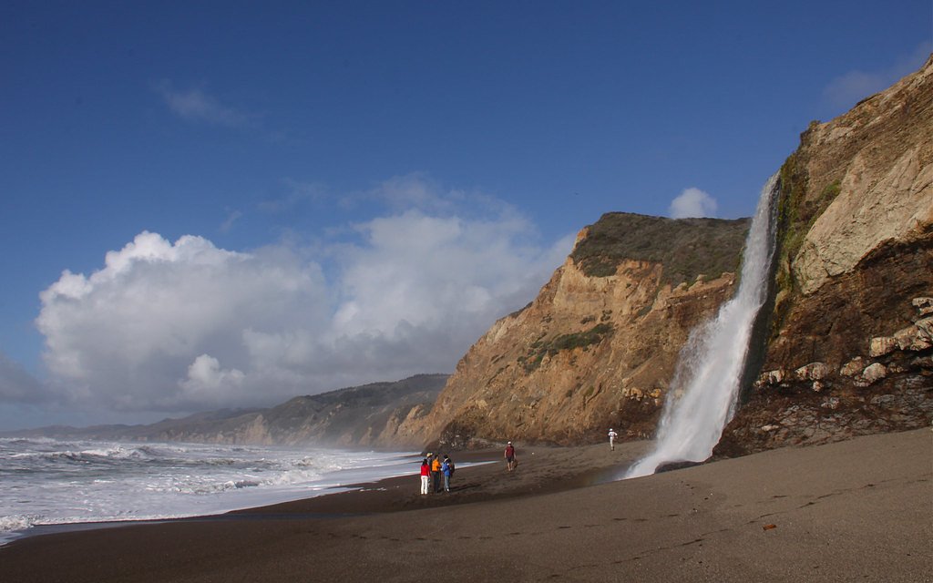
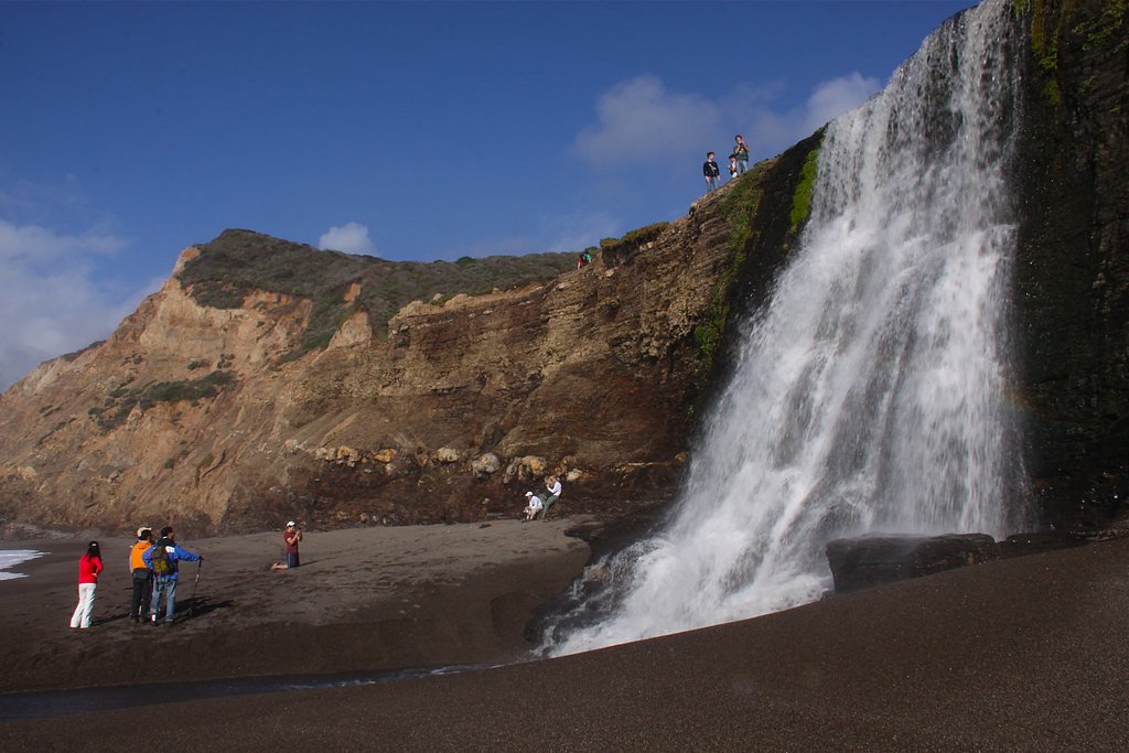
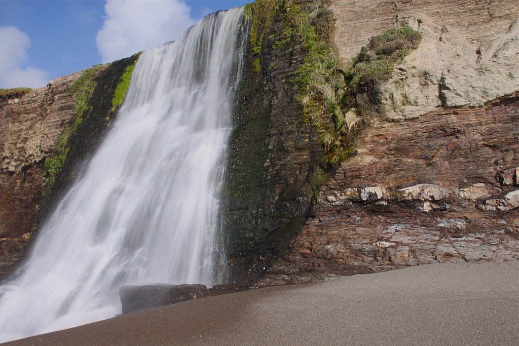
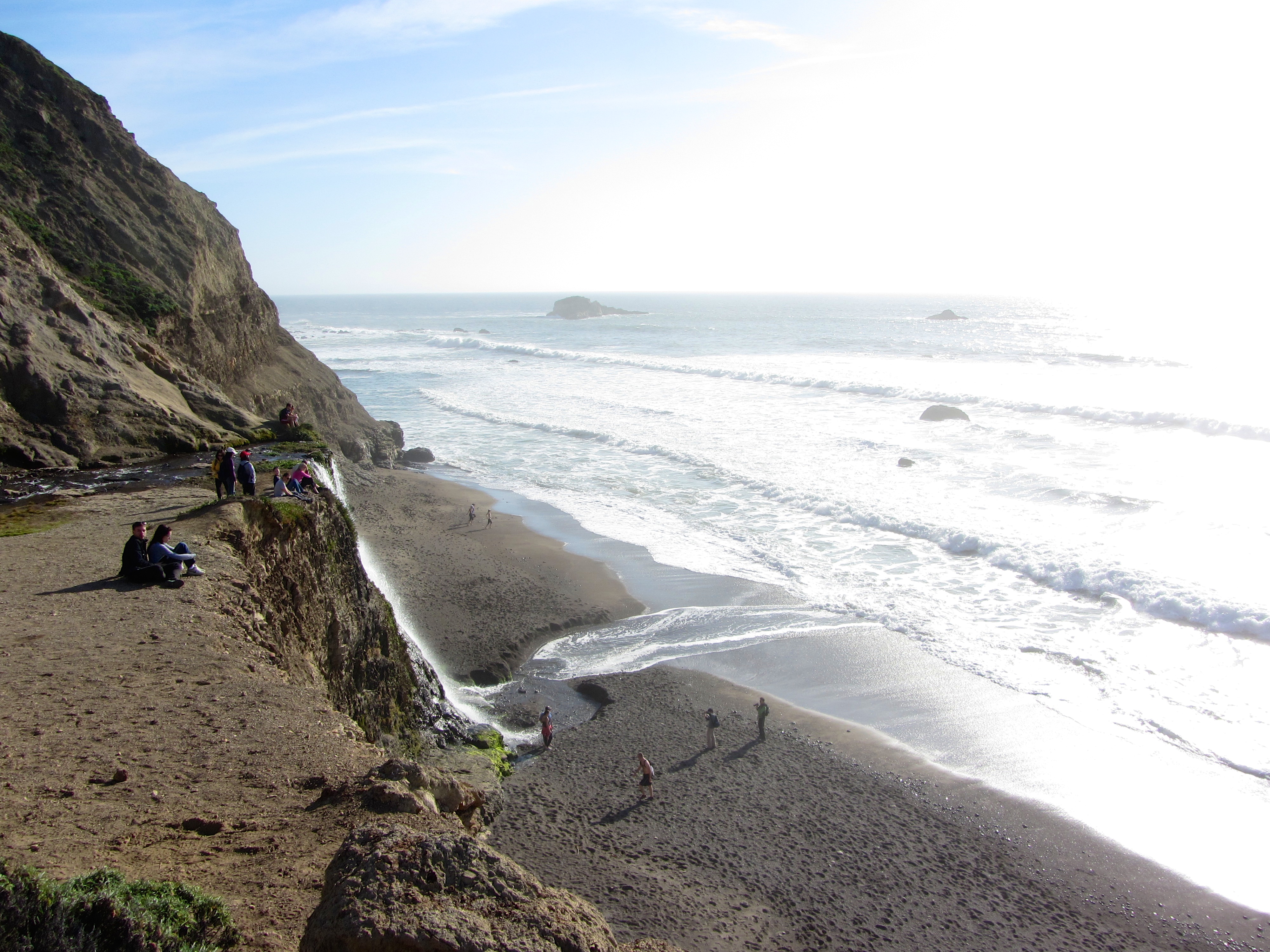
Photo Credits (5)
Difficulty
Hard
Trail Length
13.0 miles
Trail Type
Out And Back
Elevation Gain
1,600 ft
About Alamere Falls
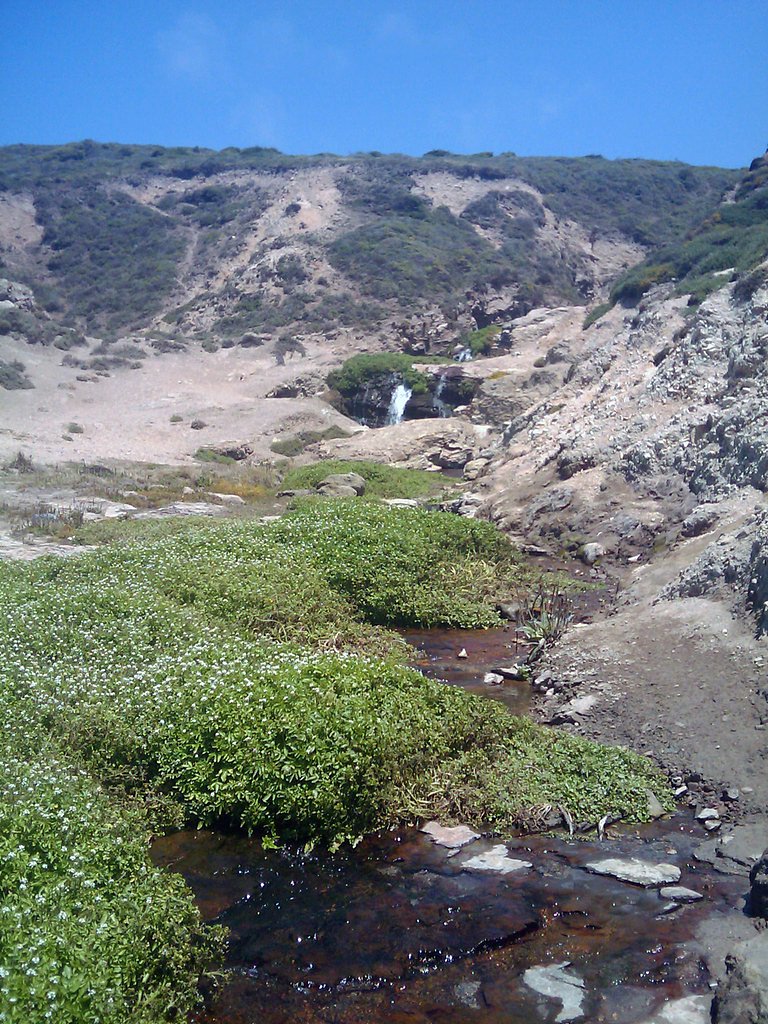
Alamere Falls is a stunning tidefall located in Point Reyes National Seashore, California. It is one of the few waterfalls in the United States that flows directly into the ocean, making it a unique and picturesque destination. The waterfall cascades over a 40-foot cliff onto Wildcat Beach, offering breathtaking views.
The Setting
Alamere Falls sits at 39 feet within Point Reyes National Seashore, in the coastal lowlands of California. The falls drop 40 feet.
Height: 40 feet
Trail & Hike Details
The Approach
The hard 13.0-mile out-and-back trail gains 1,600 feet of elevation on the way to the falls.
Trail Description
The trail to Alamere Falls begins at the Palomarin Trailhead and follows the Coast Trail. Hikers will pass through coastal scrub, eucalyptus groves, and scenic views of the Pacific Ocean. The trail includes a detour to Wildcat Camp before reaching the falls. The final descent to the beach and waterfall involves a steep and eroded scramble, which can be challenging and potentially hazardous.
What to Expect
The falls drop 40 feet.
Accessibility
The trail involves steep, uneven terrain with significant elevation change and is not accessible to mobility devices.
Frequently Asked Questions
🐶 Are Dogs Allowed at Alamere Falls?
❌ Dogs are not allowed
Are There Any Fees or Permits Required?
🆖 No fees required
🏊 Is There Swimming at Alamere Falls?
❌ Swimming is not allowed
When to Visit
Spring and early summer are ideal times to visit, as the waterfall is typically at its fullest due to seasonal rains. However, the falls can be visited year-round.
Seasonal Access
The best time to visit is Spring, Summer, Fall, and Winter.
Safety Information
The final descent to the falls is steep and eroded, requiring caution. Check tide schedules to avoid being stranded at the beach during high tide. Poison oak is common along the trail, so stay on marked paths. Carry sufficient water and be prepared for changing weather conditions.
Current Water Conditions
9 ft³/s
Current discharge — how much water is flowing
About average for this time of year
Based on 43 years of record
1.64 ft
Water depth at gauge
7-Day Discharge Trend
What does this mean for your visit?
Flow is about average for this time of year.
About This Gauge
This gauge is on a nearby waterway and may not reflect exact conditions at the falls.
7-Day Flow Outlook
Based on the USGS gauge LAGUNITAS C A SAMUEL P TAYLOR STATE PARK CA (9 km away).
Today
Moderate
9 cfs
8/10Tomorrow
Moderate
9 cfs
6/10Thu
Moderate
9 cfs
6/10Fri
Moderate
9 cfs
8/10Sat
Moderate
9 cfs
8/10Sun
Moderate
9 cfs
8/10Mon
Moderate
9 cfs
8/10Best window: Today — moderate flow, partly sunny (trip score 8/10).
Best time of year: this gauge typically runs highest from late December to late March, peaking in March.
How we calculate this
This is a transparent outlook, not a precise forecast. We take the waterfall's current flow strength (how it ranks against its historical normal for today, from the nearest USGS stream gauge), carry that ranking forward along the gauge's seasonal curve, and nudge it for forecast rain. Confidence is highest for the next day or two and falls further out. Always check official conditions and your own judgment before visiting — high flows can be dangerous.
Know when to go.
Get a free email alert when waterfalls near Bolinas hit peak flow. We only send when conditions are worth the trip — no weekly newsletters, no spam.
Weather Forecast
Location & Access
Getting There
Alamere Falls is located within Point Reyes National Seashore, about 40 miles northwest of San Francisco. The most common access point is the Palomarin Trailhead, which is reached via Mesa Road in Bolinas, California.
Get Directions on Google MapsParking
Parking is available at the Palomarin Trailhead, but it can fill up quickly, especially on weekends. Arrive early to secure a spot.
Elevation
39 feet above sea level
Coordinates
37.954246° N, -122.783410° W
Land Management
Managed by NPS
Visitor Tips & Gear
Start early to avoid crowds and secure parking. Wear sturdy hiking shoes, as the trail can be uneven and the descent to the falls is steep. Check tide schedules before visiting, as high tide can make the beach and waterfall area inaccessible. Bring plenty of water and snacks, as there are no facilities along the trail.
As an Amazon Associate, we earn from qualifying purchases.
This challenging 13.0 miles trail gains 1,600 ft in elevation — come prepared with proper hiking boots and trekking poles. Icy conditions are common in winter — traction cleats are a smart addition.

Columbia Watertight II Rain Jacket
Packs into its own pocket, seam-sealed, and keeps you dry from spray and surprise rain.

Sawyer Squeeze Water Filter
The backcountry standard — filters 99.9% of bacteria and weighs just 3 oz.

Polarized Sunglasses (Knockaround)
Cuts glare off the water so you actually see the falls — and your photos turn out better too.

Earth Pak Waterproof Dry Bag
Keeps your phone and gear dry when waterfall mist soaks everything else.

Waterproof Phone Pouch (AiRunTech)
Cheap insurance — take photos right next to the falls without killing your phone.

Timberland Euro Sprint Mid Waterproof
Trusted waterproof boot with premium leather and grippy rubber sole — reliable on rocky, wet trails.
Where to Stay

Limantour Lodge

Olema House at Point Reyes

Best Western Plus Novato Oaks Inn

Comfy Studio near Trails & Beaches
Browse vacation cabins and private rentals nearby
Unique outdoor stays — tents, yurts, and treehouses
Rent a campervan or RV for your waterfall road trip
Some links are affiliate links. We may earn a commission at no extra cost to you.
Nearby Campground
Point Reyes National Seashore Campground
6.1 miles away · 73 sites
Overview Point Reyes National Seashore offers four backcountry hike in campgrounds and thirteen boat in campsites along Tomales Bay. Note: For reservation purposes, our campgrounds are organized under the "loop" column of the reservation grid.For more information, visit the Back Country Camping page on the Point Reyes National Seashore website. Recreation Wildlife viewing Hiking Birding Backpacking Kayaking Mushroom hunting Bike riding Facilities BOOKING WINDOWS 3 month and 14-day windows. Site
Book on Recreation.govNearby Hot Springs
Hot springs near Bolinas, California

Rocky Point Springs
Rocky Point Springs emerges at 90°F along the Marin County coastline near Bolinas at the unusual elevation of negative 5 feet, ...
Unnamed Spring Sonoma County 1
This 73-degree spring in Sonoma County wine country, with recent USGS measurements of 32°C, flows at just 340 feet elevation wi...
Los Guilicos Warm Springs
Los Guilicos Warm Springs emerges at 88°F in Sonoma County wine country, producing water 28 degrees above ambient in a gentle M...

Unnamed Spring Sonoma County 2
Near Eldridge in Sonoma County, this 70-degree thermal spring flows at just 261 feet elevation with exceptional roadside access...
Mark West Springs
Mark West Springs discharges at 88°F in Sonoma County wine country, emerging just 23 feet from a public road near Larkfield-Wik...

Sulphur Spring
Sulphur Spring emerges at 75°F near San Francisco Bay, reaching temperatures 14.4 degrees warmer than the mild East Bay climate...
Looking for a soak after your hike? Explore more hot springs near Bolinas, California on SoakingSprings.
Explore California springsAdditional Information
Nearby Attractions
Other attractions in Point Reyes National Seashore include the Point Reyes Lighthouse, Chimney Rock, and Tomales Bay. Wildcat Camp is also nearby for those interested in camping.
Wildlife
The area is home to a variety of wildlife, including deer, bobcats, and numerous bird species. Marine life such as seals and whales may also be spotted along the coast.
Cities near Alamere Falls
Nearby Waterfalls
Writing about Alamere Falls? Embed this waterfall on your site for free.