Photo Credits (3)
Difficulty
Easy
Trail Length
0.5 km
Trail Type
Out And Back
Elevation Gain
10 m
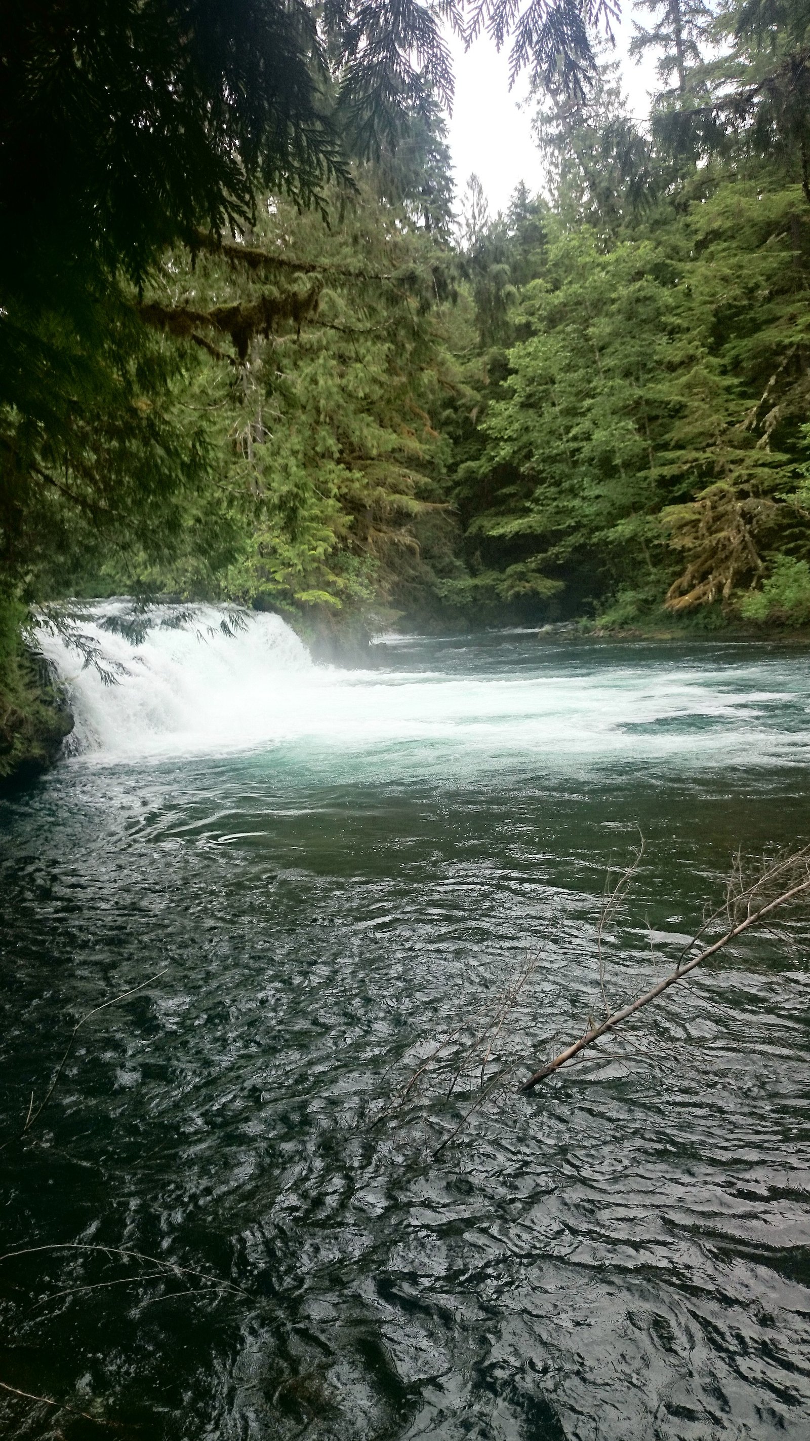
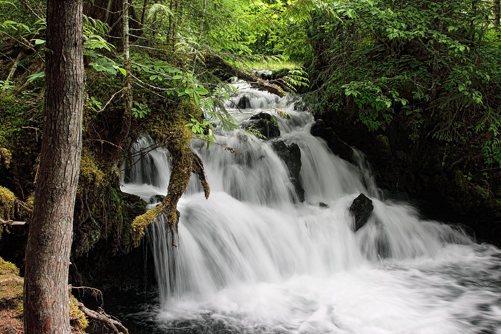
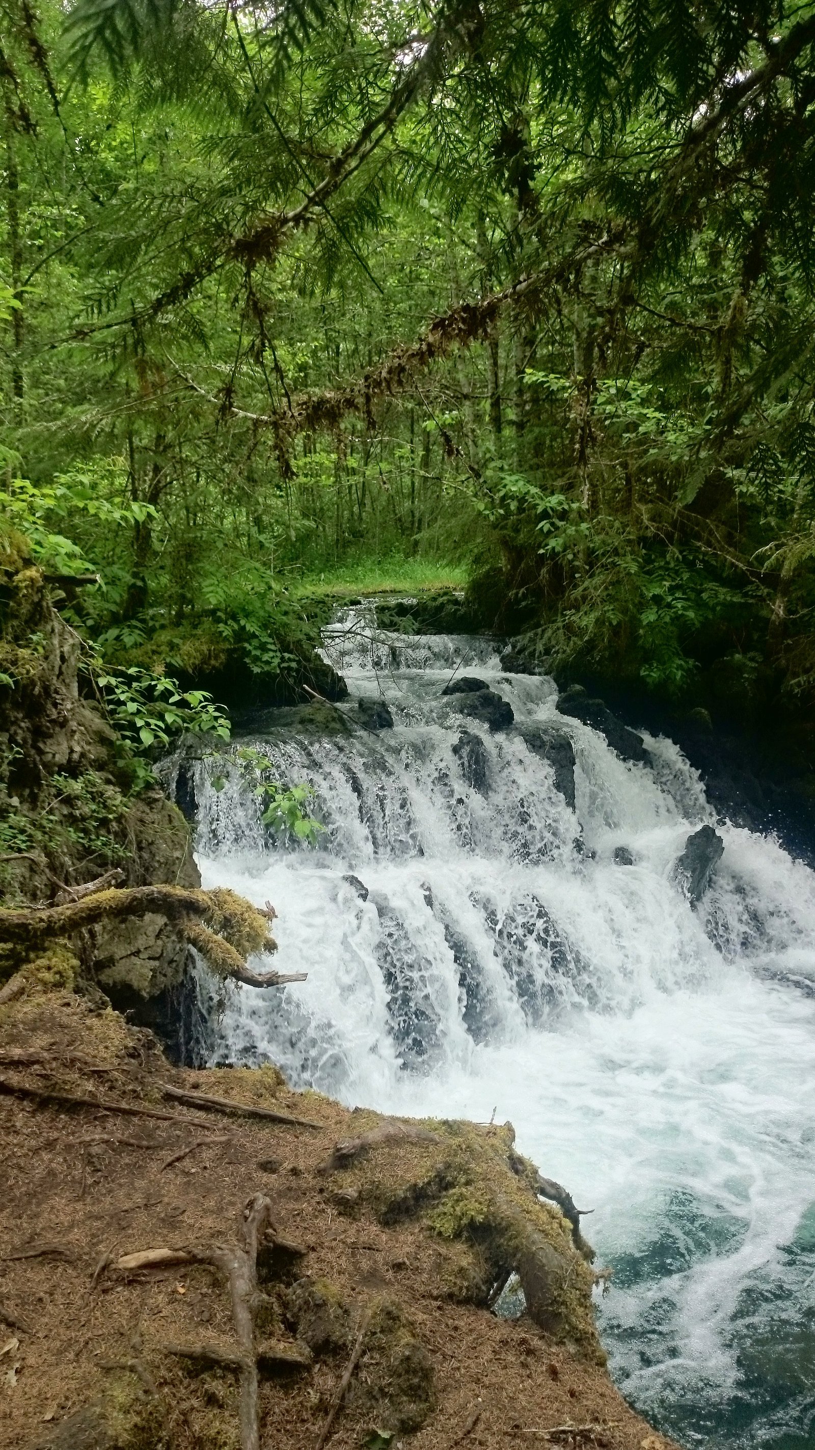
About Vetter Falls
Vetter Falls is a wooded, seasonal cascade on a tributary in northwestern British Columbia. The fall sits in a forested, remote setting and is best known to local hikers and those using logging/forest roads in the area. Flow can be highly seasonal, peak flows are typically in spring and after heavy rain. Detailed, official site development or interpretive facilities do not appear to be present; access may require travel on rough forest roads and a short informal trail or scramble to reach viewpoints.
The Setting
Vetter Falls sits at 79 metres within ANHLUUT'UKWSIM LAX̱MIHL ANGWINGA'ASANSKWHL NISG̱A'A PARK [A.K.A. NISG̱A'A MEMORIAL LAVA BED PARK], in the coastal lowlands of British Columbia.
Why This Waterfall Exists
Vetter Falls flows over layered sedimentary rock laid down about 66-201 million years ago. Over time, the stream has worn through these layers at different rates, creating the step that forms the waterfall.
Trail & Hike Details
The Approach
The easy 0.5-km out-and-back trail gains 10 metres of elevation on the way to the falls.
Trail Description
There is no widely published, maintained trail description for Vetter Falls in provincial or major trail databases. Expect an informal path or short scramble from a roadside pullout through forested terrain. Sections may be muddy, steep, or involve uneven footing; route-finding skills and caution around creek banks and wet rock are recommended. If approaching via logging roads, pay attention to gates, signage, and active logging operations.
What to Expect
Forest-dominated scenery with mossy rocks, conifers and underbrush. The waterfall is likely a cascade/series of drops rather than a single tall plunge. Flow varies with season, higher in spring/snowmelt or after heavy rains, lower in late summer and fall. Expect limited facilities (no restrooms or maintained viewpoints), possible mud, slippery rocks, and variable access depending on road conditions.
Accessibility
The trail is short and relatively flat, but the surface may be uneven. Contact the managing agency for accessibility details.
Frequently Asked Questions
🐶 Are Dogs Allowed at Vetter Falls?
❌ Dogs are not allowed
Are There Any Fees or Permits Required?
🆖 No fees required
🏊 Is There Swimming at Vetter Falls?
❌ Swimming is not allowed
When to Visit
Spring and early summer for highest flows and more dramatic water. Late summer and early fall can be drier but may offer easier road access. Winter access may be limited by snow/ice and is potentially hazardous without winter gear.
Seasonal Access
The best time to visit is Spring, Summer, and Fall. Winter access may be limited. Check with the managing park or local authority for current conditions.
Safety Information
Hazards include slippery rocks, steep or unstable banks near the water, variable water flow (strong currents in high flow), remote location with limited cell service, and possible encounters with wildlife. Logging roads can be narrow and may have heavy industrial traffic, be cautious and visible. Dress for wet and cold conditions near the water and avoid getting too close to cliff edges or undercut banks. If in doubt about road or trail safety, reconsider or seek up-to-date local advice.
Current Water Conditions
1,580.0 m³/s
Current discharge — how much water is flowing
About average for this time of year
Based on 90 years of record
5.43 m
Water depth at gauge
7-Day Discharge Trend
What does this mean for your visit?
Flow is about average for this time of year.
About This Gauge
This gauge is on a nearby waterway and may not reflect exact conditions at the falls.
7-Day Flow Outlook
Based on the WSC gauge NASS RIVER ABOVE SHUMAL CREEK (9 km away).
Today
Moderate
1630 m³/s
9/10Tomorrow
Moderate
1796 m³/s
6/10Wed
Moderate
1684 m³/s
9/10Thu
Moderate
1597 m³/s
8/10Fri
Moderate
1618 m³/s
6/10Sat
Moderate
1739 m³/s
6/10Sun
Moderate
1739 m³/s
6/10Best window: Today — moderate flow, sunny (trip score 9/10).
Best time of year: this gauge typically runs highest from mid May to mid August, peaking in June.
How we calculate this
This is a transparent outlook, not a precise forecast. We take the waterfall's current flow strength (how it ranks against its historical normal for today, from the nearest WSC stream gauge), carry that ranking forward along the gauge's seasonal curve, and nudge it for forecast rain. Confidence is highest for the next day or two and falls further out. Always check official conditions and your own judgment before visiting — high flows can be dangerous.
Know when to go.
Get a free email alert when waterfalls near Terrace hit peak flow. We only send when conditions are worth the trip — no weekly newsletters, no spam.
Weather Forecast
Location & Access
Getting There
Coordinates: 55.1781, -129.0597. Located roughly 50–55 miles from Terrace, BC (user-supplied distance ~53.3 miles). Access is typically via secondary/forest/logging roads off the main highways in the region. High-clearance or 4x4 vehicles may be needed for some forest roads; a short walk or scramble from roadside parking may be required. There is no marked provincial-park style trailhead noted in commonly available public resources, expect limited signage.
Get Directions on Google MapsParking
Likely informal roadside or small pullouts on forest roads. Parking may be limited and uneven; do not block gates, driveways, or the road. Use caution when parking on shoulders. Motorized vehicle restrictions and seasonal closures on forestry roads may affect parking availability.
Elevation
79 metres above sea level
Coordinates
55.178110° N, -129.059679° W
Land Management
Managed by Government of British Columbia
Visitor Tips & Gear
• Check local forestry/municipal resources or recent trip reports for current road conditions and closures before you go. • Use a high-clearance vehicle if you plan to travel on logging or rough forest roads. • Wear sturdy, waterproof footwear, rocks near the falls can be slippery and uneven. • Give way to forestry vehicles and obey signs/gates; some roads may be on private tenure or under active logging. • Cell service may be unreliable, bring a map/GPS and tell someone your plans. • Practice Leave No Trace: pack out what you pack in and avoid creating new social trails.
As an Amazon Associate, we earn from qualifying purchases.
For this easy 0.5 km trail, lightweight trail shoes and a water bottle are usually sufficient. Sun exposure on the trail makes good sun protection a must in summer.

Polarized Sunglasses (Knockaround)
Cuts glare off the water so you actually see the falls — and your photos turn out better too.

Columbia Watertight II Rain Jacket
Packs into its own pocket, seam-sealed, and keeps you dry from spray and surprise rain.

Earth Pak Waterproof Dry Bag
Keeps your phone and gear dry when waterfall mist soaks everything else.

Waterproof Phone Pouch (AiRunTech)
Cheap insurance — take photos right next to the falls without killing your phone.

JOBY GorillaPod Starter Kit
Wraps around railings and rocks for long-exposure waterfall shots — no flat surface needed.

Osprey Daylite Daypack
Light, organized, and just the right size for a day hike — fits water, snacks, and layers.
Where to Stay
Browse vacation cabins and private rentals nearby
Unique outdoor stays — tents, yurts, and treehouses
Rent a campervan or RV for your waterfall road trip
Some links are affiliate links. We may earn a commission at no extra cost to you.
Nearby Campground
Vetter Creek Campground
4.1 km away
Additional Information
Nearby Attractions
Nearest service town is Terrace, BC. The broader region includes Skeena River valley recreation, local fishing opportunities, and other forested streams and small falls accessible from forestry roads. Specific nearby named attractions should be confirmed with local visitor information.
Wildlife
Typical northwest BC wildlife may include black bears, deer, small mammals, and a variety of bird species. Salmon runs occur in nearby rivers and creeks in season; fishing regulations and access points vary.
Cities near Vetter Falls
Writing about Vetter Falls? Embed this waterfall on your site for free.