Tulameen Falls
By Armen Suny · Last verified Jun 2026
Difficulty
Moderate
Trail Length
2.0 km
Trail Type
Out And Back
About Tulameen Falls
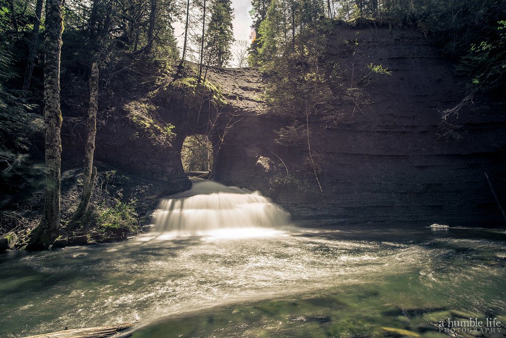
Tulameen Falls is a small, scenic waterfall in southern British Columbia near the village of Tulameen (coordinates 49.4555, -120.9842). The falls sit in a forested canyon and are reached via a short trail from a roadside/parking area. Flow and appearance vary seasonally, with higher flows in spring snowmelt and after heavy rain. Specifics about the exact height and formal name usage vary among local reports; this description uses conservative language where details are not confirmed.
Why This Waterfall Exists
Tulameen Falls flows over hard intrusive rock laid down about 66-201 million years ago. These resistant rocks form a durable ledge that water cannot easily wear away, creating the falls where softer material downstream has already eroded.
Nearby Falls Worth Visiting
Hidden Creek Falls (30 m) lies 14.3 kilometres to the northwest.
Trail & Hike Details
Trail Description
The trail to Tulameen Falls is generally a short walk from the parking/pullout and passes through mixed forest with some roots and rocks. The route may be only lightly maintained in places and can include a short scramble or steep, eroded steps near the viewpoint or the base of the falls. Expect narrow footpaths, potentially slippery surfaces when wet, and limited built infrastructure (few or no railings).
What to Expect
A modest cascade in a wooded canyon setting with rock ledges and small pools. Water flow is highest in spring and after rains and lower in late summer. The site is natural and somewhat rustic, viewpoints may be informal. Insects can be numerous in warmer months. Cell service may be intermittent; trail and parking are often informal.
Accessibility
The trail is not wheelchair accessible. Uneven terrain and elevation changes require steady footing.
Frequently Asked Questions
🐶 Are Dogs Allowed at Tulameen Falls?
❌ Dogs are not allowed
Are There Any Fees or Permits Required?
🆖 No fees required
🏊 Is There Swimming at Tulameen Falls?
❌ Swimming is not allowed
When to Visit
Spring for higher flows and greener forest; early summer for comfortable temperatures; fall for foliage colors. Avoid visiting during or immediately after heavy storms due to slippery conditions and potential for higher, hazardous flows. Winter access may be limited by snow/ice and is generally not recommended without winter backcountry experience.
Seasonal Access
The best time to visit is Spring, Summer, and Fall. Winter access may be limited. Check with the managing park or local authority for current conditions.
Safety Information
Hazards include slippery rocks and trails, steep or unstable edges, cold water and strong currents after rain or during snowmelt, falling rock in narrow canyon sections, limited cell service, and seasonal wildlife encounters (including bears). Always stay back from cliff edges, do not climb on wet rocks near the falls, tell someone your plans, and check local conditions before visiting. Carry appropriate clothing and emergency supplies.
Current Water Conditions
0.9 m³/s
Current discharge — how much water is flowing
Much lower than usual for this time of year
Based on 51 years of record
0.75 m
Water depth at gauge
7-Day Discharge Trend
What does this mean for your visit?
Flow is well below normal for this time of year, so the waterfall may be a trickle.
About This Gauge
7-Day Flow Outlook
Based on the WSC gauge TULAMEEN RIVER BELOW VUICH CREEK (1 km away).
Today
Barely Flowing
0.9 m³/s
4/10Tomorrow
Barely Flowing
0.8 m³/s
4/10Wed
Barely Flowing
0.8 m³/s
4/10Thu
Barely Flowing
0.7 m³/s
4/10Fri
Barely Flowing
0.7 m³/s
4/10Sat
Barely Flowing
0.7 m³/s
4/10Sun
Barely Flowing
0.7 m³/s
3/10Best window: Today — barely flowing flow, cloudy (trip score 4/10).
Best time of year: this gauge typically runs highest from mid April to mid July, peaking in June.
How we calculate this
This is a transparent outlook, not a precise forecast. We take the waterfall's current flow strength (how it ranks against its historical normal for today, from the nearest WSC stream gauge), carry that ranking forward along the gauge's seasonal curve, and nudge it for forecast rain. Confidence is highest for the next day or two and falls further out. Always check official conditions and your own judgment before visiting — high flows can be dangerous.
Know when to go.
Get a free email alert when waterfalls near Chilliwack hit peak flow. We only send when conditions are worth the trip — no weekly newsletters, no spam.
Weather Forecast
Location & Access
Getting There
From Highway 3 in the Tulameen/Princeton area, follow local access roads toward the Tulameen River or the small community of Tulameen. The waterfall is accessed via a short spur/trail from a roadside parking or pullout near the coordinates 49.4555, -120.9842. Road and trail conditions may change seasonally; consult local maps, recent trip reports, or authorities before travel.
Get Directions on Google MapsParking
Limited parking at a roadside pullout or small informal parking area near the trailhead. Parking is typically unpaved and may be tight; overflow parking on the shoulder may be necessary. No formal lot or fee is typically posted, but check local signage.
Elevation
1,155 metres above sea level
Coordinates
49.455530° N, -120.984249° W
Visitor Tips & Gear
Wear sturdy, grippy footwear; approach edges cautiously, rocks are slippery. Bring insect repellent in summer and a waterproof layer in wet weather. Park only in designated or safe pullouts; avoid blocking the road. Leave no trace: pack out all garbage. Check recent trip reports or local sources for current access and trail condition updates before you go.
Where to Stay
Browse vacation cabins and private rentals nearby
Unique outdoor stays — tents, yurts, and treehouses
Rent a campervan or RV for your waterfall road trip
Some links are affiliate links. We may earn a commission at no extra cost to you.
Nearby Campground
Blackeye's Plateau Camp
7.6 km away
Nearby Hot Springs
Hot springs near Chilliwack, British Columbia
Baker Hot Spring
Baker Hot Spring emerges at 108 degrees Fahrenheit on US Forest Service land in Mt. Baker National Forest, flowing 59.5 degrees...
Dorr Fumarole Field
Dorr Fumarole Field reaches 194 degrees at 8,168 feet elevation on Mount Baker's active volcanic slopes, producing superheated ...

Sherman Crater Fumaroles
Sherman Crater Fumaroles register 266 degrees Fahrenheit at 9,463 feet elevation within the active volcanic crater atop Mount B...
Looking for a soak after your hike? Explore more hot springs near Chilliwack, British Columbia on SoakingSprings.
Explore British Columbia springsAdditional Information
Nearby Attractions
Village of Tulameen and nearby small communities; Princeton is the nearest larger service center. The area is within driving distance of provincial recreational areas, backcountry access routes, and scenic highway corridors. (Note: Chilliwack ~55 mi, Glacier ~67.8 mi, and Maple Falls ~73.2 mi were provided as context; actual driving times vary.)
Wildlife
Typical southern Interior BC wildlife may be present, deer, small mammals, numerous bird species, insects, and potentially black bears. Be bear-aware in season and store food securely.
Cities near Tulameen Falls
Nearby Waterfalls
Writing about Tulameen Falls? Embed this waterfall on your site for free.