Thunder House Falls
Ontario • Missinaibi Provincial Park • 40 m
By Armen Suny · Last verified Jun 2026

Photo Credits (2)
Difficulty
Hard
Trail Length
20.0 km
Trail Type
Out And Back
About Thunder House Falls
Thunder House Falls (coordinates 50.0536, -83.1882) is a remote waterfall in northeastern Ontario, located in a sparsely populated forested area between Hearst (≈37.5 miles) and Kapuskasing (≈63.1 miles). The site appears to be on a river or stream running through typical boreal forest and may be reached via secondary roads and rough access trails. Specific trail infrastructure and official facilities appear limited or unmarked; descriptions below are conservative and describe typical conditions for small, remote Ontario waterfalls.
The Setting
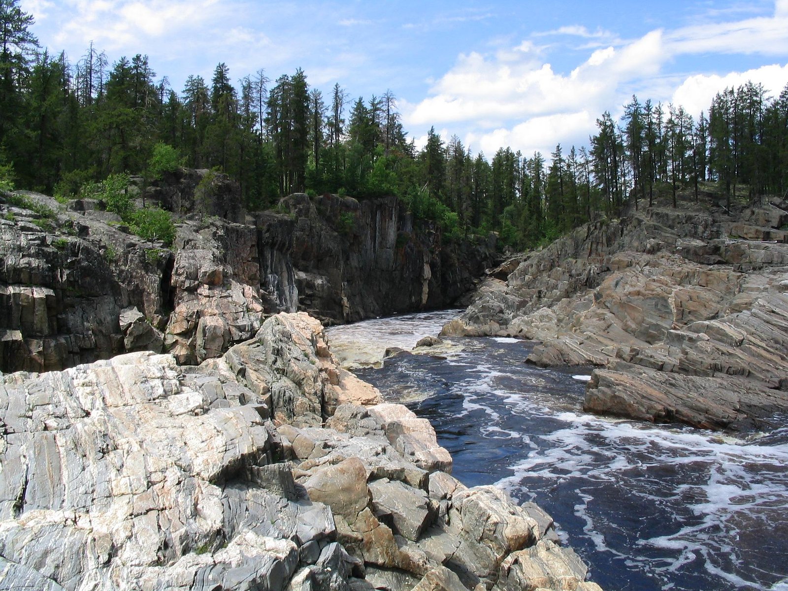
Thunder House Falls sits at 164 metres within Missinaibi Provincial Park, in the foothills of Ontario. At 40 metres, it is among the taller waterfalls in Ontario.
Why This Waterfall Exists
Thunder House Falls flows over hard banded metamorphic rock, primarily gneiss, laid down over 2.5-2.8 billion years ago. These resistant rocks form a durable ledge that water cannot easily wear away, creating a 131-foot drop where softer material downstream has already eroded.
Trail & Hike Details
Trail Description
There is likely no developed trailhead with formal infrastructure. Expect a short, informal path from a roadside pullout down to the water, over uneven, possibly muddy or root-covered ground. Approaches to the water may be steep, rocky, and slippery; route-finding could be required through forest. Where a short path exists it may be rough and unmaintained.
What to Expect
The falls cascade 40 metres over hard banded metamorphic rock.
Accessibility
The trail involves steep, uneven terrain with significant elevation change and is not accessible to mobility devices.
Frequently Asked Questions
🐶 Are Dogs Allowed at Thunder House Falls?
❌ Dogs are not allowed
Are There Any Fees or Permits Required?
🆖 No fees required
🏊 Is There Swimming at Thunder House Falls?
❌ Swimming is not allowed
When to Visit
Spring (high flow) for the most dramatic water; early fall for foliage color and more stable weather. Summer provides easier access but lower flows; winter may offer views of ice formations but roads and trails may be impassable or hazardous.
Seasonal Access
The best time to visit is Spring, Summer, and Fall. Winter access may be limited. Check with Missinaibi Provincial Park for current conditions.
Safety Information
Remote location with potentially poor cell coverage. Rocks and logs around waterfalls are slippery; falls and rapids can create strong currents and undertows. Hypothermia is a risk in cold water. Watch for changing weather and forestry or logging traffic. Seasonal insects (black flies/mosquitoes) can be intense in spring and summer. If roads to the site are unpaved, they may become impassable after rain or during freeze/thaw periods.
Current Water Conditions
Based on a Water Survey of Canada gauge 49.5 km away
26.6 m³/s
Current discharge — how much water is flowing
Lower than usual for this time of year
Based on 105 years of record
0.41 m
Water depth at gauge
7-Day Discharge Trend
What does this mean for your visit?
Flow is lower than usual for this time of year.
About This Gauge
This gauge is on a regional waterway. Conditions at the falls may differ, especially after local rain.
7-Day Flow Outlook
Based on the WSC gauge MISSINAIBI RIVER AT MATTICE (50 km away).
Today
Low
27 m³/s
5/10Tomorrow
Moderate
28 m³/s
5/10Tue
Moderate
28 m³/s
5/10Wed
Low
25 m³/s
5/10Thu
Moderate
26 m³/s
5/10Fri
Low
23 m³/s
5/10Sat
Low
21 m³/s
5/10Best window: Today — low flow, cloudy (trip score 5/10).
Best time of year: this gauge typically runs highest from mid April to early July, peaking in May.
How we calculate this
This is a transparent outlook, not a precise forecast. We take the waterfall's current flow strength (how it ranks against its historical normal for today, from the nearest WSC stream gauge), carry that ranking forward along the gauge's seasonal curve, and nudge it for forecast rain. Confidence is highest for the next day or two and falls further out. Always check official conditions and your own judgment before visiting — high flows can be dangerous.
Know when to go.
Get a free email alert when waterfalls near Hearst hit peak flow. We only send when conditions are worth the trip — no weekly newsletters, no spam.
Weather Forecast
Location & Access
Getting There
From Hearst (≈37.5 miles) or Kapuskasing (≈63.1 miles) follow regional highways toward the coordinates 50.0536, -83.1882. Expect secondary logging or access roads and some unpaved sections; exact access route may require a high-clearance vehicle. There may be no official signage. Use a reliable map (topo or GPS) and confirm local road conditions before travel.
Get Directions on Google MapsParking
Parking is likely informal and limited, may be a roadside pullout or very small unpaved lot. Vehicles should be parked clear of roadways and not block forestry access. No official parking facilities are known.
Elevation
164 metres above sea level
Coordinates
50.053604° N, -83.188238° W
Land Management
Managed by Ontario Parks
Visitor Tips & Gear
1) Tell someone your route and expected return time; cell service may be unreliable. 2) Wear sturdy, waterproof footwear with good traction; approach rocks near the falls carefully, they can be very slippery. 3) Bring insect repellent in spring/summer and layers for changing weather. 4) Avoid edges and fast water; currents can be deceptively strong. 5) Respect private property and forestry operations, do not trespass on gated roads or posted land.
Where to Stay
Browse vacation cabins and private rentals nearby
Unique outdoor stays — tents, yurts, and treehouses
Rent a campervan or RV for your waterfall road trip
Some links are affiliate links. We may earn a commission at no extra cost to you.
Additional Information
Nearby Attractions
Small northern Ontario communities (Hearst and Kapuskasing) offer services; the region also contains numerous rivers, lakes, and forested areas suitable for fishing, canoeing, and backcountry hiking. Specific nearby official parks or maintained trails are not confirmed for this exact coordinate.
Wildlife
Typical boreal species may be present: moose, black bear, white-tailed deer, wolves/foxes, beaver, and a variety of birds (raptors, waterfowl, songbirds). Take standard wildlife precautions (store food securely, give animals space).
Cities near Thunder House Falls
Writing about Thunder House Falls? Embed this waterfall on your site for free.