Swallow River Falls
Ontario • Pukaskwa National Park • 2 m
By Armen Suny · Last verified Jun 2026
Difficulty
Moderate
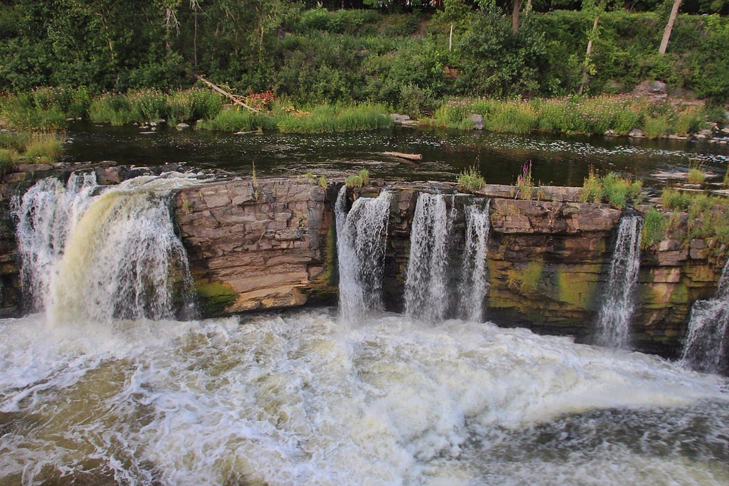
About Swallow River Falls
Swallow River Falls is a forested-river waterfall located near Marathon, Ontario (approx. 40.5 miles / ~65 km from Marathon). The falls sit on the Swallow River and appear as a series of cascades and drops through a bedrock channel surrounded by mixed boreal forest. Flow and appearance can vary seasonally, highest flows are typically in spring snowmelt and after heavy rains, while late summer flows may be reduced. Exact measured height is not confirmed here.
The Setting
Swallow River Falls sits at 200 metres within Pukaskwa National Park, in the foothills of Ontario. The falls drop 2 metres.
Why This Waterfall Exists
Swallow River Falls flows over hard intrusive rock laid down over 2.5-2.8 billion years ago. These resistant rocks form a durable ledge that water cannot easily wear away, creating a 6-foot drop where softer material downstream has already eroded.
Trail & Hike Details
Trail Description
There does not appear to be a highly developed or heavily signed trail to Swallow River Falls. Expect a natural footpath through mixed forest with roots, rocks and occasional wet or muddy sections. The final approach to the river and ledges may be steep and uneven; visitors may need to scramble short sections and exercise caution on wet rock. Trail length and vertical gain are not reliably documented here, plan for a one-way hike that could range from a short walk to several kilometers depending on the chosen access point. Follow established social trails where available and avoid creating new paths that damage vegetation or destabilize banks.
What to Expect
The falls drop a gentle 2 metres over hard intrusive rock.
Accessibility
The trail is not wheelchair accessible. Uneven terrain and elevation changes require steady footing.
Frequently Asked Questions
🐶 Are Dogs Allowed at Swallow River Falls?
❌ Dogs are not allowed
Are There Any Fees or Permits Required?
🆖 No fees required
🏊 Is There Swimming at Swallow River Falls?
❌ Swimming is not allowed
When to Visit
Late spring (snowmelt) for highest flows and dramatic cascades; early summer for milder weather with reasonable flows. Fall offers color and cooler temperatures; winter can produce icefalls but is hazardous and requires winter travel experience and equipment. Avoid times immediately after heavy rain if you are inexperienced with river terrain.
Seasonal Access
The best time to visit is Spring, Summer, Fall, and Winter. Check with Pukaskwa National Park for current conditions.
Safety Information
Primary hazards: slippery rock and ledges, steep or unstable banks, fast or cold water, limited cell coverage, and variable road conditions to the trailhead. Seasonal hazards include ice in winter and high water in spring or after storms. If using logging roads or remote access routes, watch for work vehicles and seasonal closures. Carry emergency supplies and know basic navigation and first aid.
Current Water Conditions
Based on a Water Survey of Canada gauge 25.5 km away
0.9 m³/s
Current discharge — how much water is flowing
Lower than usual for this time of year
Based on 13 years of record
3.65 m
Water depth at gauge
7-Day Discharge Trend
What does this mean for your visit?
Flow is lower than usual for this time of year.
About This Gauge
This gauge is on a regional waterway. Conditions at the falls may differ, especially after local rain.
7-Day Flow Outlook
Based on the WSC gauge PUKASKWA RIVER BELOW FOX RIVER (25 km away).
Today
Low
0.9 m³/s
5/10Tomorrow
Low
1.0 m³/s
4/10Tue
Low
0.9 m³/s
5/10Wed
Low
0.8 m³/s
5/10Thu
Low
0.9 m³/s
4/10Fri
Low
0.8 m³/s
5/10Sat
Low
0.8 m³/s
4/10Best window: Today — low flow, cloudy (trip score 5/10).
Best time of year: this gauge typically runs highest from mid April to early June, peaking in May.
How we calculate this
This is a transparent outlook, not a precise forecast. We take the waterfall's current flow strength (how it ranks against its historical normal for today, from the nearest WSC stream gauge), carry that ranking forward along the gauge's seasonal curve, and nudge it for forecast rain. Confidence is highest for the next day or two and falls further out. Always check official conditions and your own judgment before visiting — high flows can be dangerous.
Know when to go.
Get a free email alert when waterfalls near Marathon hit peak flow. We only send when conditions are worth the trip — no weekly newsletters, no spam.
Weather Forecast
Location & Access
Getting There
Approximate coordinates: 48.1748, -86.074 (user-supplied). From Marathon, the falls are roughly 40–41 miles (about 65 km) away. Access is likely via secondary or logging roads off the Trans-Canada Highway (Highway 17) and then by a footpath; expect unpaved roads and limited signage. Vehicle access beyond a parking/turnout may require high-clearance or 4WD, depending on season and road maintenance. Cell service may be intermittent; bring a map or GPS track and plan for remote conditions.
Get Directions on Google MapsParking
There may be no formal parking lot. Expect limited roadside parking or informal pullouts near the trailhead. Park clear of roadways and private driveways; if uncertain, return to the nearest community (Marathon) for guidance. Use caution when parking on soft shoulders after rain.
Elevation
200 metres above sea level
Coordinates
48.174814° N, -86.073953° W
Land Management
Managed by Parks Canada Agency
Visitor Tips & Gear
• Tell someone your plan and expected return time; cell coverage may be intermittent. • Wear sturdy, waterproof hiking boots with good traction; approach rocks and ledges with care. • Bring insect repellent in spring/summer and layered clothing for changing weather. • Carry water, snacks, a basic first-aid kit and a map/GPS, do not rely solely on cell navigation. • Do not get too close to the edge of cliffs or slippery rocks; river currents can be deceptively strong. • Pack out all trash and follow Leave No Trace principles. • If access uses logging roads, watch for working vehicles and follow posted signs.
Where to Stay
Browse vacation cabins and private rentals nearby
Unique outdoor stays — tents, yurts, and treehouses
Rent a campervan or RV for your waterfall road trip
Some links are affiliate links. We may earn a commission at no extra cost to you.
Nearby Campground
Trappers Harbour 1
1.1 km away
Additional Information
Nearby Attractions
Town of Marathon (services), Lake Superior shoreline and beaches, provincial parks in the region such as Neys Provincial Park and portions of Lake Superior Provincial Park (distances vary); many recreational lakes and rivers in the area for fishing and paddling.
Wildlife
Typical boreal wildlife: moose, white-tailed deer, black bear, beaver, various waterfowl and songbirds. Insects: black flies and mosquitoes in late spring/early summer. Take standard wildlife precautions: store food securely, keep dogs leashed, and give large animals a wide berth.
Cities near Swallow River Falls
Nearby Waterfalls
Writing about Swallow River Falls? Embed this waterfall on your site for free.