Photo Credits (1)
Difficulty
Moderate
Trail Length
1.9 km
Trail Type
Out And Back
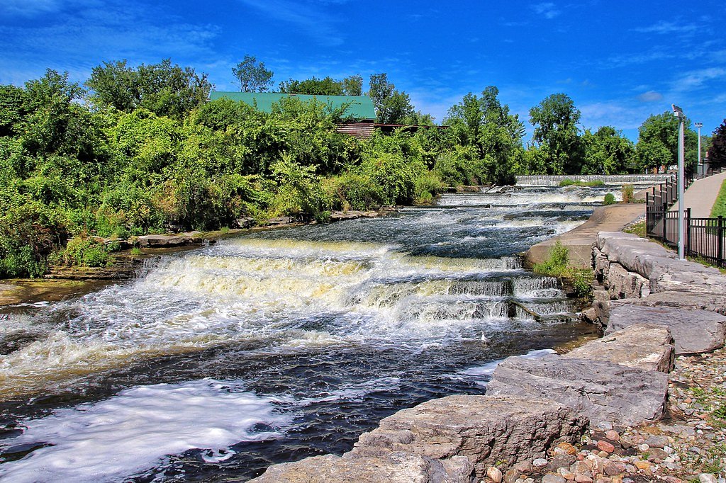
About Small Falls
Small Falls is a modest, likely multi-step cascade in the Lake Superior region near Marathon, Ontario (coordinates provided). It appears to be a natural, undeveloped waterfall set in mixed boreal forest. Flow and appearance are highly seasonal, typically higher in spring melt and after rain, reduced in late summer, and often partly or fully frozen in winter. There are limited official descriptions available; exact physical characteristics and developed facilities are not well documented.
Why This Waterfall Exists
Small Falls flows over hard volcanic rock laid down over 2.5-2.8 billion years ago. These resistant rocks form a durable ledge that water cannot easily wear away, creating the falls where softer material downstream has already eroded.
Trail & Hike Details
Trail Description
There is limited publicly available, authoritative trail information for Small Falls. Approaches are likely over natural, unpaved terrain through boreal forest with roots, rocks, and potentially muddy or wet sections near the stream. Trails (if present) may be faint and involve some short scrambling near the water. Expect no handrails or developed viewing platforms unless noted locally.
What to Expect
A small natural cascade rather than a large dramatic drop. Variable water flow: strong in spring/after rain, reduced in dry periods. Natural, undeveloped setting with forested surroundings and rocky stream banks. Limited or no facilities, signage, or maintained trails. Possible slippery rocks, steep banks, and unstable footing near the water. Seasonal changes: ice and snow in winter can create attractive frozen features but also very hazardous conditions.
Accessibility
The trail is not wheelchair accessible. Uneven terrain and elevation changes require steady footing.
Frequently Asked Questions
🐶 Are Dogs Allowed at Small Falls?
❌ Dogs are not allowed
Are There Any Fees or Permits Required?
🆖 No fees required
🏊 Is There Swimming at Small Falls?
❌ Swimming is not allowed
When to Visit
Spring (late March–May) for highest flows and dramatic water movement; early summer for good hiking conditions and vegetation; fall for foliage colors. Winter can offer ice formations but increases hazard from ice, snow and limited access.
Seasonal Access
The best time to visit is Spring, Summer, Fall, and Winter. Check with the managing park or local authority for current conditions.
Safety Information
Hazards may include slippery rock and moss, steep or unstable banks, cold water, strong currents after rain or during spring melt, limited cell service, and wildlife (including bears and moose). In winter, ice and snow introduce serious slip and fall risks and make roads impassable in places. Always tell someone your plans, carry appropriate safety gear, and avoid risky approaches near edges or under overhangs. Use caution and conservative judgment around water and cliffs.
Current Water Conditions
0.6 m³/s
Current discharge — how much water is flowing
About average for this time of year
Based on 41 years of record
7.20 m
Water depth at gauge
7-Day Discharge Trend
What does this mean for your visit?
Flow is about average for this time of year.
About This Gauge
This gauge is on a nearby waterway and may not reflect exact conditions at the falls.
7-Day Flow Outlook
Based on the WSC gauge CEDAR CREEK NEAR HEMLO (15 km away).
Today
Moderate
0.6 m³/s
6/10Tomorrow
Moderate
0.6 m³/s
5/10Tue
Moderate
0.6 m³/s
5/10Wed
Moderate
0.6 m³/s
5/10Thu
Moderate
0.6 m³/s
5/10Fri
Moderate
0.6 m³/s
6/10Sat
Moderate
0.6 m³/s
5/10Best window: Today — moderate flow, cloudy (trip score 6/10).
Best time of year: this gauge typically runs highest from mid April to mid June, peaking in May.
How we calculate this
This is a transparent outlook, not a precise forecast. We take the waterfall's current flow strength (how it ranks against its historical normal for today, from the nearest WSC stream gauge), carry that ranking forward along the gauge's seasonal curve, and nudge it for forecast rain. Confidence is highest for the next day or two and falls further out. Always check official conditions and your own judgment before visiting — high flows can be dangerous.
Know when to go.
Get a free email alert when waterfalls near Marathon hit peak flow. We only send when conditions are worth the trip — no weekly newsletters, no spam.
Weather Forecast
Location & Access
Getting There
The falls are located near Marathon, Ontario (approx. 25.3 miles from Marathon as noted). Access typically requires driving on secondary or unpaved forest/logging roads off Highway 17 and then a short walk. Exact route to the site is not published by a single official source; visitors should use detailed local maps, GPS coordinates (48.8345, -85.8671), and confirm road conditions locally before travelling. Expect limited signage.
Get Directions on Google MapsParking
There is likely no formal parking lot or facilities. Parking may be roadside or a small informal pull-out. Park legally and avoid blocking gates or driveways. Facilities (toilets, garbage bins) are likely not present.
Elevation
312 metres above sea level
Coordinates
48.834459° N, -85.867096° W
Visitor Tips & Gear
• Confirm route and road conditions locally in Marathon before you go; unpaved roads can be rough or closed. • Wear sturdy, grippy footwear and dress for changing weather. • Bring a map/GPS and a charged phone; cell coverage may be limited. • Leave no trace: pack out all trash. • Keep a safe distance from the edge; wet rocks and moss are slippery. • If visiting in bear country, follow bear-safety practices (secure food, make noise, carry bear spray where appropriate). • If uncertain about land ownership (crown land vs. private), verify access permissions.
Where to Stay
Browse vacation cabins and private rentals nearby
Unique outdoor stays — tents, yurts, and treehouses
Rent a campervan or RV for your waterfall road trip
Some links are affiliate links. We may earn a commission at no extra cost to you.
Nearby Campground
White Lake Provincial Park Campground
22.4 km away
Additional Information
Nearby Attractions
The town of Marathon and the Lake Superior shoreline are nearby. The broader region includes provincial parks, scenic coastal viewpoints, and other natural attractions, check local visitor information for specifics and distances.
Wildlife
Typical northern Ontario wildlife may be present: black bears, moose, deer, foxes, small mammals, and a variety of birds and aquatic life. Take usual precautions for wildlife encounters.
Cities near Small Falls
Writing about Small Falls? Embed this waterfall on your site for free.