Siffleur Falls
Alberta • 15 m
By Armen Suny · Last verified Jun 2026
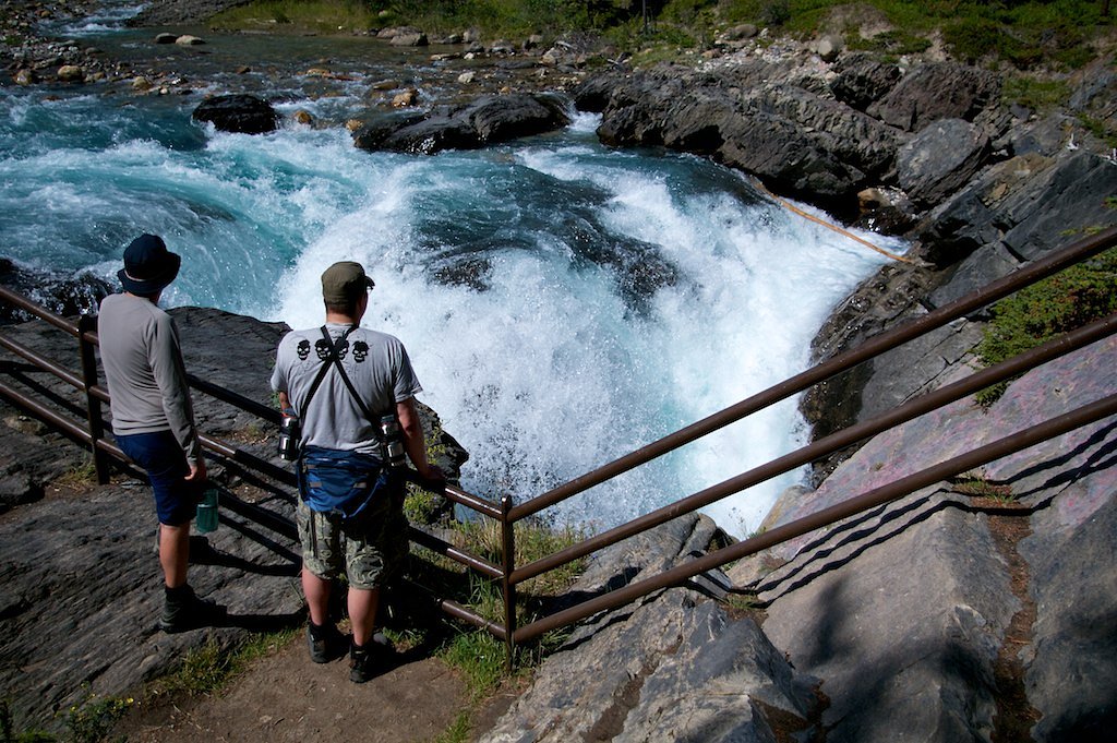

Photo Credits (2)
Difficulty
Moderate
Trail Length
7.1 km
Trail Type
Out And Back
Elevation Gain
145 m
About Siffleur Falls
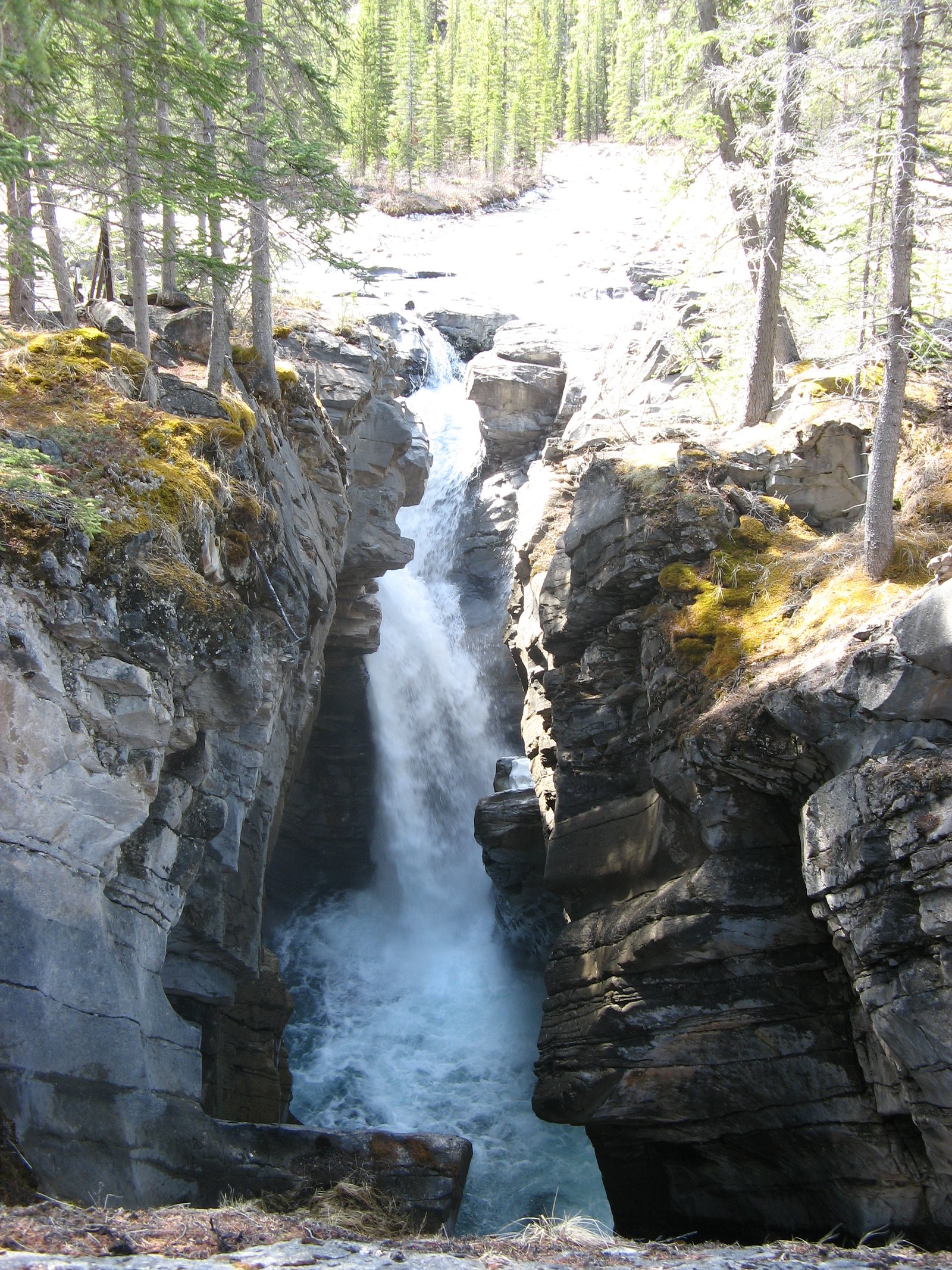
Siffleur Falls are a series of three separate waterfalls on the Siffleur River, an early tributary of the North Saskatchewan River. The falls are a short distance from the David Thompson Highway, in the Siffleur Wilderness Area, just north of Banff National Park.
The Setting
Siffleur Falls sits at 1,382 metres within Kootenay Plains Ecological Reserve, in the mountains of Alberta. The falls drop 15 metres.
Why This Waterfall Exists
Siffleur Falls flows over layered carbonate rock, primarily limestone and dolomite, laid down about 323-359 million years ago. These soft rocks erode readily, allowing the stream to carve a 49-foot drop into the landscape.
Trail & Hike Details
The Approach
The moderate 7.1-km out-and-back trail gains 145 metres of elevation on the way to the falls.
Trail Description
The trail is a short out-and-back that leaves the parking pullout and follows a well-defined natural footpath toward the river. Expect packed dirt and rocky sections; the approach passes through subalpine forest and opens onto viewpoints above the falls. There are informal lookouts and a short scramble in places to reach better vantage points. The route is generally short and straightforward but can be slippery near the water and on wet rock.
What to Expect
The falls drop 15 metres over layered carbonate rock.
Accessibility
The trail is not wheelchair accessible. Uneven terrain and elevation changes require steady footing.
Frequently Asked Questions
🐶 Are Dogs Allowed at Siffleur Falls?
❌ Dogs are not allowed
Are There Any Fees or Permits Required?
🆖 No fees required
🏊 Is There Swimming at Siffleur Falls?
❌ Swimming is not allowed
When to Visit
Late spring to early summer for higher flows from snowmelt; summer for reliably dry trail access and milder weather; early fall for fall colors and fewer crowds. Winter can offer dramatic, iced falls but requires winter travel skills and equipment (snowshoes/traction) and access may be limited.
Seasonal Access
The best time to visit is Spring, Summer, Fall, and Winter. Check with the managing park or local authority for current conditions.
Safety Information
Hazards include slippery rocks and riverbanks, fast currents, sudden weather changes, cold water, limited cell service, and wildlife encounters (including bears). Trails and viewpoints can be icy or snow-covered outside summer months. Use caution near edges and do not attempt to climb on unstable rock. Carry emergency supplies and let someone know your plans if traveling in remote areas.
Current Water Conditions
239.0 m³/s
Current discharge — how much water is flowing
Much higher than usual for this time of year
Based on 56 years of record
2.18 m
Water depth at gauge
7-Day Discharge Trend
What does this mean for your visit?
The water is flowing much higher than usual, expect an impressive display.
About This Gauge
7-Day Flow Outlook
Based on the WSC gauge NORTH SASKATCHEWAN RIVER AT WHIRLPOOL POINT (8 km away).
Today
Roaring
258 m³/s
6/10Tomorrow
Roaring
266 m³/s
6/10Tue
Roaring
269 m³/s
6/10Wed
Roaring
262 m³/s
9/10Thu
Roaring
254 m³/s
8/10Fri
Roaring
281 m³/s
6/10Sat
Roaring
260 m³/s
9/10Best window: Wed — roaring flow, mainly sunny (trip score 9/10).
Best time of year: this gauge typically runs highest from early June to early September, peaking in July.
How we calculate this
This is a transparent outlook, not a precise forecast. We take the waterfall's current flow strength (how it ranks against its historical normal for today, from the nearest WSC stream gauge), carry that ranking forward along the gauge's seasonal curve, and nudge it for forecast rain. Confidence is highest for the next day or two and falls further out. Always check official conditions and your own judgment before visiting — high flows can be dangerous.
Know when to go.
Get a free email alert when waterfalls near Lake Louise hit peak flow. We only send when conditions are worth the trip — no weekly newsletters, no spam.
Weather Forecast
Location & Access
Getting There
From the David Thompson Highway (Highway 11) use the signed pullout for Siffleur Falls. The trailhead is accessed from a small day-use parking area/pullout directly off the highway. The falls are located in a relatively remote area of the front ranges of the Rockies; the nearest well-known landmark is Lake Louise (approximately 37.8 miles / ~60.8 km by road, per provided context). Road and weather conditions can affect access, check current highway and local information before travel.
Get Directions on Google MapsParking
Small roadside pullout/day-use parking area. Spaces are limited, and parking may be tight during peak season. There are typically no services (no potable water or staffed facilities). A vault toilet may or may not be present; visitors should be prepared for minimal facilities.
Elevation
1,382 metres above sea level
Coordinates
52.038207° N, -116.378718° W
Land Management
Managed by Parks Division, Alberta Forestry and Parks
Visitor Tips & Gear
Wear sturdy, closed-toe shoes with good traction. Stay on designated trails and avoid getting too close to the river edge or slippery rocks. Carry water, layers, and insect repellent in summer. Check weather and highway conditions before traveling. Practice bear-aware behavior (make noise, carry bear spray and know how to use it), wildlife is present in the area. Arrive early on summer weekends to secure parking.
As an Amazon Associate, we earn from qualifying purchases.
With 7.1 km and 145 m of elevation gain, sturdy boots and trekking poles will help on this moderate trail. Icy conditions are common in winter — traction cleats are a smart addition.

Columbia Watertight II Rain Jacket
Packs into its own pocket, seam-sealed, and keeps you dry from spray and surprise rain.

Polarized Sunglasses (Knockaround)
Cuts glare off the water so you actually see the falls — and your photos turn out better too.

Earth Pak Waterproof Dry Bag
Keeps your phone and gear dry when waterfall mist soaks everything else.

Waterproof Phone Pouch (AiRunTech)
Cheap insurance — take photos right next to the falls without killing your phone.

Timberland Euro Sprint Mid Waterproof
Trusted waterproof boot with premium leather and grippy rubber sole — reliable on rocky, wet trails.

TrailBuddy Trekking Poles
Lightweight aluminum, cork grips, and flip-locks that actually hold — a best-seller for good reason.
Where to Stay
Browse vacation cabins and private rentals nearby
Unique outdoor stays — tents, yurts, and treehouses
Rent a campervan or RV for your waterfall road trip
Some links are affiliate links. We may earn a commission at no extra cost to you.
Nearby Campground
Preacher's North Rustic Camping Area
6.7 km away
Additional Information
Nearby Attractions
David Thompson Highway scenic drive, Abraham Lake, Icefields Parkway access points, Nordegg area attractions, other roadside viewpoints and small waterfalls along the David Thompson corridor. Lake Louise is approximately 37.8 miles (per provided context).
Wildlife
Wildlife in the area may include black and grizzly bears, elk, deer, moose, small mammals, and various bird species. Practice caution and proper food storage; make noise on the trail.
Cities near Siffleur Falls
Writing about Siffleur Falls? Embed this waterfall on your site for free.