Photo Credits (5)
About Rupert Falls
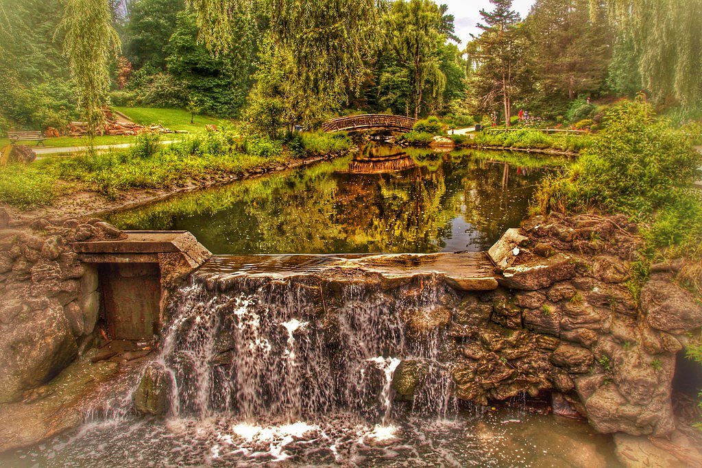
Rupert Falls is a forested cascade located in the Greenstone/Thunder Bay region of northwestern Ontario, approximately 32 miles (about 52 km) from Geraldton (coordinates 50.2842, -87.0763). The falls are set on a small creek/tributary in a mixed boreal forest and are most notable for seasonal flow variation (higher in spring snowmelt and after heavy rains). There are no formal facilities at the site; access is generally via logging/secondary roads and a short unmaintained path or scramble to the creek. Precise published height and official park designation appear not to be documented in major databases, so some site details may vary by season and access route.
Why This Waterfall Exists
Rupert Falls flows over volcanic rock laid down over 2.5-2.8 billion years ago. These resistant rocks form a durable ledge that water cannot easily wear away, creating the falls where softer material downstream has already eroded.
Trail & Hike Details
Trail Description
There does not appear to be a developed, signed trail from a major trailhead to Rupert Falls. Access is typically via secondary/forestry roads with a short unmarked path, bushwhack, or scramble down to the creek. Trail surfaces are likely uneven, with roots, rocks, mud, and possibly wet sections close to the water. Expect no boardwalks, railings, or maintained viewing platforms.
What to Expect
A small to medium cascade in a heavily forested boreal setting. Flow is highest in spring (snowmelt) and after heavy rains; summer flows may be reduced. The immediate area is natural and undeveloped: fallen logs, wet rocks, and typical northern Ontario underbrush. Insects (mosquitoes, blackflies) can be abundant in warm months. Wildlife such as moose, black bear, and small mammals inhabit the region; sightings are possible but not guaranteed.
Accessibility
No known accessibility features. The site is likely not wheelchair accessible. Approach involves unmaintained surfaces and possible scrambling.
Frequently Asked Questions
🐶 Are Dogs Allowed at Rupert Falls?
❌ Dogs are not allowed
Are There Any Fees or Permits Required?
🆖 No fees required
🏊 Is There Swimming at Rupert Falls?
❌ Swimming is not allowed
When to Visit
Late spring for the best water flow and early summer or fall for easier access and comfortable weather. Avoid periods immediately after heavy rains for road safety unless you have a high-clearance vehicle; winter can offer scenic frozen falls but requires winter travel skills and equipment.
Seasonal Access
The best time to visit is Spring, Summer, Fall, and Winter. Check with the managing park or local authority for current conditions.
Safety Information
Hazards include slippery and unstable rock near the falls, fast or cold water, undercut banks, poor or no cell coverage, variable road conditions (mud, washouts), and wildlife encounters. Always tell someone your plans, carry basic emergency supplies, and avoid approaching the edge of the waterfall. In winter, ice and deep snow can create additional hazards and require proper equipment and experience.
Know when to go.
Get a free email alert when waterfalls near Geraldton hit peak flow. We only send when conditions are worth the trip — no weekly newsletters, no spam.
Weather Forecast
Location & Access
Getting There
From Geraldton, travel by vehicle toward the general coordinates (50.2842, -87.0763). Expect to use local secondary or forestry roads; some sections may be rough or gated. Final approach is likely on a short unmarked trail or roadside access. Cell coverage may be intermittent; bring maps/GPS and confirm road conditions locally before travel.
Get Directions on Google MapsParking
No developed parking lot is known to be provided. Visitors typically park at a roadside pullout or primitive parking area near the trailhead or logging road. Park clear of gates or private driveways and avoid blocking access.
Elevation
318 metres above sea level
Coordinates
50.284190° N, -87.076268° W
Visitor Tips & Gear
1) Check local forestry/municipal road conditions before you go; some roads may be seasonally gated or in poor condition. 2) Wear sturdy hiking shoes with good traction; rocks near the falls can be slippery. 3) Bring insect repellent in late spring and summer. 4) Expect minimal or no signage, download offline maps or take GPS coordinates. 5) Practice Leave No Trace: pack out all trash. 6) Keep a safe distance from edges and fast water; currents and undercut banks can be hazardous. 7) If traveling in bear country, carry bear deterrent and know how to use it.
Where to Stay
Browse vacation cabins and private rentals nearby
Unique outdoor stays — tents, yurts, and treehouses
Rent a campervan or RV for your waterfall road trip
Some links are affiliate links. We may earn a commission at no extra cost to you.
Nearby Campground
Cordingley Lake Campground
27.3 km away
Additional Information
Nearby Attractions
Town of Geraldton (services), other natural areas and lakes in the Greenstone/Thunder Bay region; anglers and hikers often explore local lakes and trails in the surrounding boreal landscape. Specific named nearby attractions may require local guidance to locate.
Wildlife
Black bear, moose, white-tailed deer, beaver, wolves, small mammals, and abundant insects (mosquitoes, blackflies, ticks). Practice wildlife safety and bear-aware protocols.
Cities near Rupert Falls
Nearby Waterfalls
Writing about Rupert Falls? Embed this waterfall on your site for free.