Pine Creek Falls
By Armen Suny · Last verified Jun 2026
Photo Credits (1)
Difficulty
Moderate
Trail Length
3.7 km
Trail Type
Out And Back
Elevation Gain
105 m
About Pine Creek Falls
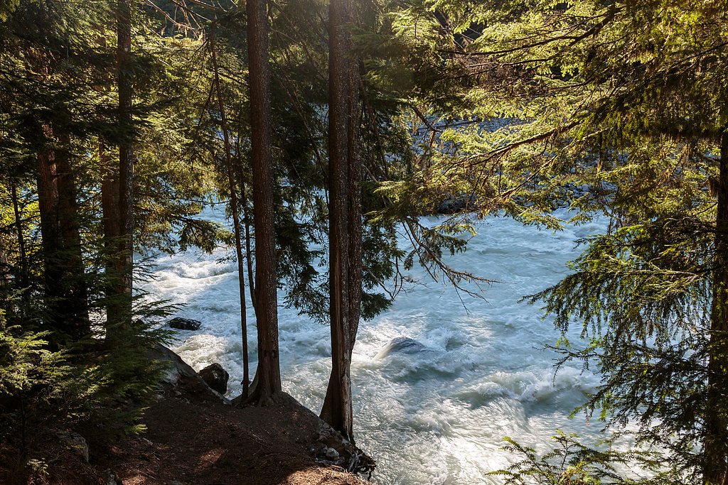
Pine Creek Falls is a forested cascade located on Pine Creek in northern British Columbia near Atlin. The falls sit in a remote, heavily treed setting typical of the region, expect moss-covered rocks, narrow channels, and a relatively small but scenic drop. Public information is limited; descriptions below use conservative language where exact details are not confirmed.
Why This Waterfall Exists
Pine Creek Falls flows over layered sedimentary rock laid down about 145-359 million years ago. Over time, the stream has worn through these layers at different rates, creating the step that forms the waterfall.
Trail & Hike Details
The Approach
The moderate 3.7-km out-and-back trail gains 105 metres of elevation on the way to the falls.
Trail Description
Trail information is limited and may vary by season. Where an informal trail exists it is typically a short beaten path or scramble from a roadside or small parking area through forest and brush to the creek and viewpoint. Expect uneven footing, tree roots, and possibly steep or eroded sections near the water. There may be no maintained switchbacks, railings, or formal viewpoints.
What to Expect
A small to moderate waterfall in a remote northern-BC forest setting. Water flow typically peaks in spring during snowmelt and can be lower in late summer. The site is likely wooded with limited clearing for views; reaching the best vantage may require short bushwhacks or scrambling over rocks. Cell service is likely unreliable. Weather can change quickly and insects (mosquitoes/blackflies) may be heavy in summer.
Accessibility
The trail is not wheelchair accessible. Uneven terrain and elevation changes require steady footing.
Frequently Asked Questions
🐶 Are Dogs Allowed at Pine Creek Falls?
❌ Dogs are not allowed
Are There Any Fees or Permits Required?
🆖 No fees required
🏊 Is There Swimming at Pine Creek Falls?
❌ Swimming is not allowed
When to Visit
Late spring to early summer for highest flows (snowmelt). Mid to late summer for easier road and trail access and more stable weather. Fall can offer quieter visits and good foliage; winter access may be difficult or unsafe due to snow and ice.
Seasonal Access
The best time to visit is Spring, Summer, and Fall. Winter access may be limited. Check with the managing park or local authority for current conditions.
Safety Information
Expect remoteness and limited or no cell service. Hazards include slippery rocks, steep or eroded banks, fast or cold water, unstable ground near edges, and changing weather. Bear encounters are possible, carry and know how to use bear spray, make noise while hiking, and keep a clean campsite if staying nearby. Roads may be rough; check conditions before driving. In winter, avalanche and ice hazards may apply. Always tell someone your plan and expected return time.
Current Water Conditions
159.0 m³/s
Current discharge — how much water is flowing
About average for this time of year
Based on 74 years of record
7-Day Discharge Trend
What does this mean for your visit?
Flow is about average for this time of year.
About This Gauge
This gauge is on a nearby waterway and may not reflect exact conditions at the falls.
7-Day Flow Outlook
Based on the WSC gauge ATLIN RIVER NEAR ATLIN (11 km away).
Today
Moderate
172 m³/s
6/10Tomorrow
Moderate
181 m³/s
6/10Thu
Moderate
171 m³/s
8/10Fri
Moderate
182 m³/s
6/10Sat
Moderate
192 m³/s
6/10Sun
Moderate
183 m³/s
8/10Mon
Moderate
179 m³/s
6/10Best window: Thu — moderate flow, cloudy (trip score 8/10).
Best time of year: this gauge typically runs highest from mid July to mid October, peaking in August.
How we calculate this
This is a transparent outlook, not a precise forecast. We take the waterfall's current flow strength (how it ranks against its historical normal for today, from the nearest WSC stream gauge), carry that ranking forward along the gauge's seasonal curve, and nudge it for forecast rain. Confidence is highest for the next day or two and falls further out. Always check official conditions and your own judgment before visiting — high flows can be dangerous.
Weather Forecast
Location & Access
Getting There
The falls are located near coordinates 59.5917, -133.6191 in northern BC. The nearest community is Atlin, BC (the falls may be accessed from local forest or logging roads and short trails branching off roads). Roads in the area can be rough and may require high-clearance or 4x4 vehicles; some access may involve hiking from the nearest serviceable parking area. Exact approach routes are not confirmed here, check local maps, area logging companies, or Atlin community resources before traveling.
Get Directions on Google MapsParking
Likely informal roadside pullout or small unimproved parking area. Expect little to no formal facilities, signage, or maintained parking lots.
Elevation
802 metres above sea level
Coordinates
59.591748° N, -133.619129° W
Visitor Tips & Gear
1) Check with local sources in Atlin (visitor center, ranger office, or local outfitters) for current access, road conditions, and any closures. 2) Use a high-clearance vehicle if attempting forest/logging roads and avoid wet or heavily rutted roads. 3) Wear sturdy footwear; approach involves uneven and potentially slippery terrain. 4) Carry bear safety tools and know how to use them. 5) Leave no trace: there are likely no services or waste facilities.
As an Amazon Associate, we earn from qualifying purchases.
With 3.7 km and 105 m of elevation gain, sturdy boots and trekking poles will help on this moderate trail. Sun exposure on the trail makes good sun protection a must in summer.

Polarized Sunglasses (Knockaround)
Cuts glare off the water so you actually see the falls — and your photos turn out better too.

Columbia Watertight II Rain Jacket
Packs into its own pocket, seam-sealed, and keeps you dry from spray and surprise rain.

Earth Pak Waterproof Dry Bag
Keeps your phone and gear dry when waterfall mist soaks everything else.

Waterproof Phone Pouch (AiRunTech)
Cheap insurance — take photos right next to the falls without killing your phone.

Timberland Euro Sprint Mid Waterproof
Trusted waterproof boot with premium leather and grippy rubber sole — reliable on rocky, wet trails.

TrailBuddy Trekking Poles
Lightweight aluminum, cork grips, and flip-locks that actually hold — a best-seller for good reason.
Where to Stay
Browse vacation cabins and private rentals nearby
Unique outdoor stays — tents, yurts, and treehouses
Rent a campervan or RV for your waterfall road trip
Some links are affiliate links. We may earn a commission at no extra cost to you.
Nearby Campground
Pine Creek Campground
4.4 km away
Additional Information
Nearby Attractions
Atlin Lake and the town of Atlin are the nearest notable attractions; hiking, local trails, and scenic viewpoints around Atlin may offer additional options. Exact nearby trailheads and official attractions should be verified locally.
Wildlife
Typical northern BC wildlife may be present: black bears, moose, wolves, and smaller mammals and birds. Insect activity (mosquitoes, blackflies) can be intense in summer. Practice wildlife safety and food storage.
Writing about Pine Creek Falls? Embed this waterfall on your site for free.