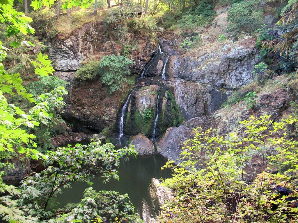
Nitinat Falls
By Armen Suny · Last verified Jun 2026
Photo Credits (2)
About Nitinat Falls
Nitinat Falls (sometimes referenced at the Nitinat Narrows) is a coastal/estuarine fall/rapids feature on southwestern Vancouver Island near the outlet of Nitinat Lake toward the Pacific. The site is notable for strong tidal flows and turbulent water where lake/river water exchanges with the ocean; flow character and appearance change dramatically with the tide. The location is remote and approach often uses forestry/secondary roads or boat access. Specific historic height measurements are not well documented; conditions and access details vary by season and tide.
The Setting
Nitinat Falls sits at 102 metres within NITINAT RIVER PARK, in the coastal lowlands of British Columbia.
Why This Waterfall Exists
Nitinat Falls flows over volcanic rock laid down about 162-201 million years ago. These resistant rocks form a durable ledge that water cannot easily wear away, creating the falls where softer material downstream has already eroded.
Trail & Hike Details
Trail Description
There is no widely maintained or highly developed trail documented for Nitinat Falls. Access typically involves short, informal footpaths from a roadside pullout or boat landing, or travel by water. Trails (if present) may be rough, muddy, steep in places, and unmarked. Expect limited signage and no handrails or developed viewpoints.
What to Expect
Expect a remote, rugged coastal environment with powerful, tide-driven currents at the narrows. Rocks and shoreline can be slippery; water flow and visible 'fall' features vary with tide and season. There are few or no visitor facilities (no toilets or potable water). Cell coverage may be poor. Weather can change quickly on the coast.
Accessibility
Remote, uneven terrain with no developed facilities, not wheelchair or stroller accessible. Expect rough footpaths and natural obstacles.
Frequently Asked Questions
🐶 Are Dogs Allowed at Nitinat Falls?
❌ Dogs are not allowed
Are There Any Fees or Permits Required?
🆖 No fees required
🏊 Is There Swimming at Nitinat Falls?
❌ Swimming is not allowed
When to Visit
Late spring through early fall for easier road access and milder weather. For the most dramatic water movement, plan visits around strong tidal exchanges (check local tide charts), spring tides and times near peak ebb/flood often show the strongest currents.
Seasonal Access
The best time to visit is Spring, Summer, and Fall. Winter access may be limited. Check with the managing park or local authority for current conditions.
Safety Information
Major hazards include strong tide-driven currents and turbulent water at the narrows, slippery and unstable shoreline rocks, steep and unmaintained approaches, quickly changing weather, and limited cell coverage or emergency services. Do not approach the edge of fast-moving water; check tide tables; use caution on unmaintained roads and trails. If traveling on forestry roads, watch for logging traffic and obey signage.
Current Water Conditions
0.0 m³/s
Current discharge — how much water is flowing
Much lower than usual for this time of year
Based on 27 years of record
0.60 m
Water depth at gauge
7-Day Discharge Trend
What does this mean for your visit?
Flow is well below normal for this time of year, so the waterfall may be a trickle.
About This Gauge
This gauge is on a nearby waterway and may not reflect exact conditions at the falls.
7-Day Flow Outlook
Based on the WSC gauge COTTONWOOD CREEK HEADWATERS (23 km away).
Today
Barely Flowing
0.0 m³/s
5/10Tomorrow
Barely Flowing
0.0 m³/s
4/10Tue
Barely Flowing
0.0 m³/s
4/10Wed
Barely Flowing
0.0 m³/s
4/10Thu
Barely Flowing
0.0 m³/s
4/10Fri
Barely Flowing
0.0 m³/s
4/10Sat
Barely Flowing
0.0 m³/s
3/10Best window: Today — barely flowing flow, mainly sunny (trip score 5/10).
Best time of year: this gauge typically runs highest from early January to late January, peaking in January.
How we calculate this
This is a transparent outlook, not a precise forecast. We take the waterfall's current flow strength (how it ranks against its historical normal for today, from the nearest WSC stream gauge), carry that ranking forward along the gauge's seasonal curve, and nudge it for forecast rain. Confidence is highest for the next day or two and falls further out. Always check official conditions and your own judgment before visiting — high flows can be dangerous.
Know when to go.
Get a free email alert when waterfalls near Nanaimo hit peak flow. We only send when conditions are worth the trip — no weekly newsletters, no spam.
Weather Forecast
Location & Access
Getting There
Nitinat Falls is on southwestern Vancouver Island near Nitinat Lake/Nitinat Narrows. Approaches are typically from Port Renfrew or the Lake Cowichan/Nitinat directions via a mix of paved and gravel/forestry roads. Some visitors approach by boat via Nitinat Lake. Road conditions can be rough, seasonal, and may require high-clearance or 4x4 vehicles; check current road status and local maps before travel. The coordinates for the reported location are approximately 48.8993, -124.5531.
Get Directions on Google MapsParking
Parking is informal and limited. There is no developed parking lot or visitor facilities at the falls. Expect roadside parking or pullouts on gravel roads; observe private property signs and avoid blocking access roads.
Elevation
102 metres above sea level
Coordinates
48.899308° N, -124.553099° W
Land Management
Managed by Government of British Columbia
Visitor Tips & Gear
• Check tide tables before visiting, tidal phase strongly affects what you will see and safety. • Use a high-clearance vehicle and check local road reports; forestry roads may be closed or in poor condition. • Tell someone your plan and expected return time; cellphone signal may be unreliable. • Wear sturdy, waterproof footwear; bring layers and rain gear. • Do not venture onto slippery rocks near the flowing narrows; strong currents and undercut banks are hazards. • Respect private property and posted closures; follow Leave No Trace principles.
Where to Stay
Browse vacation cabins and private rentals nearby
Unique outdoor stays — tents, yurts, and treehouses
Rent a campervan or RV for your waterfall road trip
Some links are affiliate links. We may earn a commission at no extra cost to you.
Nearby Campground
Kissinger Campsite
5.8 km away
Additional Information
Nearby Attractions
Nitinat Lake (known for wind/kite surfing in certain conditions), Port Renfrew and its coastal beaches, the West Coast of Vancouver Island (wilderness and surf beaches), regional forests and backcountry opportunities. Several provincial parks and backcountry trails are on Vancouver Island but confirm exact distances and access.
Wildlife
Coastal and forest wildlife may include black bears, cougars, deer, elk, bald eagles, seabirds, and marine mammals offshore. Be bear-aware and follow wildlife safety best practices.
Cities near Nitinat Falls
Nearby Waterfalls
Writing about Nitinat Falls? Embed this waterfall on your site for free.