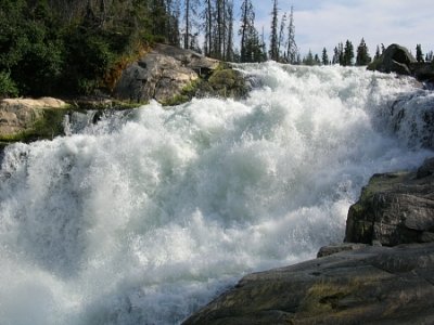
Nistowiak Falls
Saskatchewan • 10 m
By Armen Suny · Last verified Jun 2026

Photo Credits (1)
Difficulty
Easy
Trail Length
1.9 km
Trail Type
Out And Back
About Nistowiak Falls
Nistowiak Falls, at 10 metres (33 ft), is one of the highest waterfalls in the province of Saskatchewan, Canada. The falls are on the Rapid River, which flows north from Iskwatikan Lake into Nistowiak Lake on the Churchill River. Nistowiak is a Cree word referring to the convergence of waters.
The Setting
Nistowiak Falls sits at 349 metres within Lac La Ronge Provincial Park, in the foothills of Saskatchewan. The falls drop 10 metres.
Why This Waterfall Exists
Nistowiak Falls flows over hard metamorphic rock, primarily amphibolite, laid down about 539 million to 2.5 billion years ago. These resistant rocks form a durable ledge that water cannot easily wear away, creating a 33-foot drop where softer material downstream has already eroded.
Trail & Hike Details
Trail Description
There is no widely maintained conventional hiking trail to the falls from a public road; most visitors access the falls by water (boat or canoe) or by floatplane and then walk short distances over rocky shorelines and ledges to viewpoints. Expect uneven, rocky terrain close to the water, occasional short portages if approaching by canoe, and unmarked route-finding in places. Local outfitters or guides often provide the most direct and safest access options.
What to Expect
The falls drop 10 metres over hard metamorphic rock.
Accessibility
The trail is not wheelchair accessible. Uneven terrain and elevation changes require steady footing.
Frequently Asked Questions
🐶 Are Dogs Allowed at Nistowiak Falls?
❌ Dogs are not allowed
Are There Any Fees or Permits Required?
🆖 No fees required
🏊 Is There Swimming at Nistowiak Falls?
❌ Swimming is not allowed
When to Visit
Late spring (high water) through early fall offers best access by boat and the most dramatic water flow. Summer provides more stable weather and easier travel conditions; fall brings color but cooler temperatures. Winter access is possible in some years by snowmobile or winter aircraft, but ice/seasonal conditions make access more hazardous, check local authorities.
Seasonal Access
The best time to visit is Spring, Summer, and Fall. Winter access may be limited. Check with the managing park or local authority for current conditions.
Safety Information
Hazards include strong currents, slippery and unstable rock near the falls, steep drop-offs, cold water and hypothermia risk, fast-changing weather, biting insects in summer, and remoteness (limited cell service). If traveling by boat or canoe, wear a properly fitted life jacket and have appropriate experience for river conditions. Carry emergency communication and first aid supplies. Check ice and river conditions in spring and fall before travel.
Current Water Conditions
51.9 m³/s
Current discharge — how much water is flowing
About average for this time of year
Based on 21 years of record
7.16 m
Water depth at gauge
7-Day Discharge Trend
What does this mean for your visit?
Flow is about average for this time of year.
About This Gauge
This gauge is on a nearby waterway and may not reflect exact conditions at the falls.
7-Day Flow Outlook
Based on the WSC gauge RAPID RIVER AT OUTLET OF LAC LA RONGE (10 km away).
Today
Moderate
59 m³/s
6/10Tomorrow
Moderate
60 m³/s
6/10Tue
Moderate
54 m³/s
8/10Wed
Moderate
52 m³/s
8/10Thu
Moderate
56 m³/s
6/10Fri
Moderate
58 m³/s
6/10Sat
Moderate
58 m³/s
6/10Best window: Tue — moderate flow, cloudy (trip score 8/10).
Best time of year: this gauge typically runs highest from mid June to mid September, peaking in July.
How we calculate this
This is a transparent outlook, not a precise forecast. We take the waterfall's current flow strength (how it ranks against its historical normal for today, from the nearest WSC stream gauge), carry that ranking forward along the gauge's seasonal curve, and nudge it for forecast rain. Confidence is highest for the next day or two and falls further out. Always check official conditions and your own judgment before visiting — high flows can be dangerous.
Know when to go.
Get a free email alert when waterfalls near La Ronge hit peak flow. We only send when conditions are worth the trip — no weekly newsletters, no spam.
Weather Forecast
Location & Access
Getting There
The falls are in remote north-central Saskatchewan (approx. 55.3957, -104.3666) and are typically reached by boat or floatplane from communities such as Stanley Mission or La Ronge, or as part of a longer canoe trip through Lac La Ronge Provincial Park and the Churchill/Rapid River system. Road access is not available directly to the falls; expect water or air travel plus short landings/portages.
Get Directions on Google MapsParking
Parking information depends on your chosen launch point (for example, Stanley Mission or other trailheads/boat launches). Park at official boat-launch parking areas or park facilities; do not park in undesignated roadside areas. Check local park/municipal signage for overnight parking rules.
Elevation
349 metres above sea level
Coordinates
55.395676° N, -104.366623° W
Land Management
Managed by Government of Saskatchewan, Ministry of Tourism, Parks, Culture and Sport
Visitor Tips & Gear
• Arrange water or air transport in advance (local outfitters or charter operators). • Tell someone your travel plan and expected return time. • Wear sturdy shoes for slippery, uneven rock near the falls; stay well back from the edge. • Bring insect repellent, sun/rain protection, and extra layers, northern weather can be cool and wet. • Pack out all garbage. • If travelling by canoe/kayak, be prepared for strong currents and portages; only experienced paddlers should attempt river travel near rapids. • Check in with Lac La Ronge Provincial Park or local authorities for up-to-date access advice and regulations.
Where to Stay
Browse vacation cabins and private rentals nearby
Unique outdoor stays — tents, yurts, and treehouses
Rent a campervan or RV for your waterfall road trip
Some links are affiliate links. We may earn a commission at no extra cost to you.
Additional Information
Nearby Attractions
Stanley Mission (settlement and historic mission), Lac La Ronge Provincial Park, Churchill River provincial waterways and canoe routes. The broader region offers fishing, canoeing, and cultural/historical sites related to local Indigenous communities.
Wildlife
Typical boreal wildlife includes moose, black bear, wolves, beaver, and a variety of waterfowl and songbirds. Exercise standard wildlife safety: store food securely and make noise when hiking.
Cities near Nistowiak Falls
Writing about Nistowiak Falls? Embed this waterfall on your site for free.