Photo Credits (1)
Difficulty
Moderate
Trail Length
1.6 km
Trail Type
Out And Back
Elevation Gain
102 m
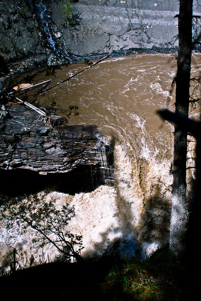
About Muskeg Falls
Muskeg Falls appears to be a remote, small waterfall or cascade located in boreal forest and muskeg (bog) country in northern Alberta. Flow is likely seasonal and driven by snowmelt and rainfall; the feature may be a cascade on a small stream rather than a large vertical drop. There is limited published information about developed facilities or maintained trails to this exact coordinate, so access and conditions may vary year to year.
Why This Waterfall Exists
Muskeg Falls flows over layered sedimentary rock, primarily sandstone, laid down about 66-101 million years ago. These soft rocks erode readily, allowing the stream to carve a vertical drop into the landscape.
Trail & Hike Details
The Approach
The moderate 1.6-km out-and-back trail gains 102 metres of elevation on the way to the falls.
Trail Description
There is no confirmed maintained trail to Muskeg Falls at the provided coordinates. Approach may require route-finding across muskeg, bogs, wet forest, and unmaintained logging tracks. Expect soft, wet ground, potentially little to no defined footpath, and sections of uneven or slippery terrain near the stream. Travel can be slow and physically demanding even over short distances due to muskeg and brush.
What to Expect
Remote boreal forest environment with wetlands (muskeg), black spruce, willows, and possibly stands of aspen or birch. In spring the falls may be at higher flow from snowmelt; summer flows may be reduced. Typical northern pests (black flies, mosquitoes) in warmer months. Little or no facilities (no restrooms, signage, or managed viewpoints). Limited cell service and no emergency services nearby except by long-distance call or air/ground rescue.
Accessibility
The trail is not wheelchair accessible. Uneven terrain and elevation changes require steady footing.
Frequently Asked Questions
🐶 Are Dogs Allowed at Muskeg Falls?
❌ Dogs are not allowed
Are There Any Fees or Permits Required?
🆖 No fees required
🏊 Is There Swimming at Muskeg Falls?
❌ Swimming is not allowed
When to Visit
Late spring (snowmelt) for higher flows and accessible roads; summer for more stable weather and easier travel though insects will be active; early fall for lower flows but fewer bugs and fall colors. Winter access is possible only for experienced winter travelers (snowmobile, skis) and conditions can be hazardous; ice and deep snow may make travel difficult or dangerous.
Seasonal Access
The best time to visit is Spring, Summer, and Fall. Winter access may be limited. Check with the managing park or local authority for current conditions.
Safety Information
Hazards include: unstable and slippery banks near water; deep or soft muskeg that can impede travel; rapidly changing weather; limited or no cell reception and long emergency response times; wildlife encounters (bears, moose); ticks in some seasons; biting insects in summer. Do not attempt to cross streams on slick rocks, and avoid getting too close to edges. Use conservative safety margins and travel with companions when possible.
Current Water Conditions
9.6 m³/s
Current discharge — how much water is flowing
About average for this time of year
Based on 52 years of record
3.37 m
Water depth at gauge
7-Day Discharge Trend
What does this mean for your visit?
Flow is about average for this time of year.
About This Gauge
7-Day Flow Outlook
Based on the WSC gauge MUSKEG RIVER NEAR GRANDE CACHE (5 km away).
Today
Moderate
10 m³/s
6/10Tomorrow
Moderate
11 m³/s
6/10Tue
Moderate
9.2 m³/s
8/10Wed
Moderate
8.6 m³/s
9/10Thu
Moderate
8.5 m³/s
8/10Fri
Moderate
9.0 m³/s
6/10Sat
Moderate
9.2 m³/s
6/10Best window: Wed — moderate flow, mainly sunny (trip score 9/10).
Best time of year: this gauge typically runs highest from early May to early August, peaking in May.
How we calculate this
This is a transparent outlook, not a precise forecast. We take the waterfall's current flow strength (how it ranks against its historical normal for today, from the nearest WSC stream gauge), carry that ranking forward along the gauge's seasonal curve, and nudge it for forecast rain. Confidence is highest for the next day or two and falls further out. Always check official conditions and your own judgment before visiting — high flows can be dangerous.
Weather Forecast
Location & Access
Getting There
The coordinates (53.9373, -118.883) place this location in remote boreal/muskeg country in northern Alberta. Access is likely via secondary logging/forest roads, ATV trails, or by boat/floatplane depending on the nearest waterway; expect no maintained trailhead or signage. Visitors should plan for off-trail navigation, limited or no cell service, and potential seasonal road closures (spring thaw/winter). Use a GPS device and topographic maps; confirm local road conditions with regional forestry or land management offices before travel.
Get Directions on Google MapsParking
There is likely no formal parking area or developed trailhead. If visiting by road, you may find informal pullouts on forestry roads; these can be muddy, soft, or closed seasonally. Park well off the roadway and avoid blocking gates or access roads.
Elevation
1,082 metres above sea level
Coordinates
53.937342° N, -118.883041° W
Visitor Tips & Gear
1) Treat this as a backcountry visit: tell someone your plan and expected return time. 2) Bring a reliable GPS and topographic map; coordinates are essential for locating the site. 3) Wear waterproof boots and gaiters for muskeg and wet ground. 4) Carry insect repellent and consider a head net in summer. 5) Carry bear spray and know how to use it; make noise while traveling. 6) Avoid approaching edges of wet, boggy banks, they can be unstable and slippery. 7) Check local forestry/land management offices for road and access advisories.
As an Amazon Associate, we earn from qualifying purchases.
With 1.6 km and 102 m of elevation gain, sturdy boots and trekking poles will help on this moderate trail. Sun exposure on the trail makes good sun protection a must in summer.

Polarized Sunglasses (Knockaround)
Cuts glare off the water so you actually see the falls — and your photos turn out better too.

Columbia Watertight II Rain Jacket
Packs into its own pocket, seam-sealed, and keeps you dry from spray and surprise rain.

Earth Pak Waterproof Dry Bag
Keeps your phone and gear dry when waterfall mist soaks everything else.

Waterproof Phone Pouch (AiRunTech)
Cheap insurance — take photos right next to the falls without killing your phone.

Timberland Euro Sprint Mid Waterproof
Trusted waterproof boot with premium leather and grippy rubber sole — reliable on rocky, wet trails.

TrailBuddy Trekking Poles
Lightweight aluminum, cork grips, and flip-locks that actually hold — a best-seller for good reason.
Where to Stay
Browse vacation cabins and private rentals nearby
Unique outdoor stays — tents, yurts, and treehouses
Rent a campervan or RV for your waterfall road trip
Some links are affiliate links. We may earn a commission at no extra cost to you.
Nearby Campground
Sheep Creek Campground
16.1 km away
Additional Information
Nearby Attractions
This area is typical northern Alberta boreal wilderness, nearby attractions, if any, are likely to be unstaffed natural features, lakes, and forest lands. For formal parks or maintained recreation sites, consult Alberta Parks or local municipal resources for more exact nearby destinations.
Wildlife
Typical boreal species may include moose, black bear, deer, wolves, beavers, and a variety of birds and small mammals. Insects (mosquitoes and black flies) can be intense in warmer months.
Writing about Muskeg Falls? Embed this waterfall on your site for free.