Murray Creek Falls
British Columbia • 49 m
By Armen Suny · Last verified Jun 2026

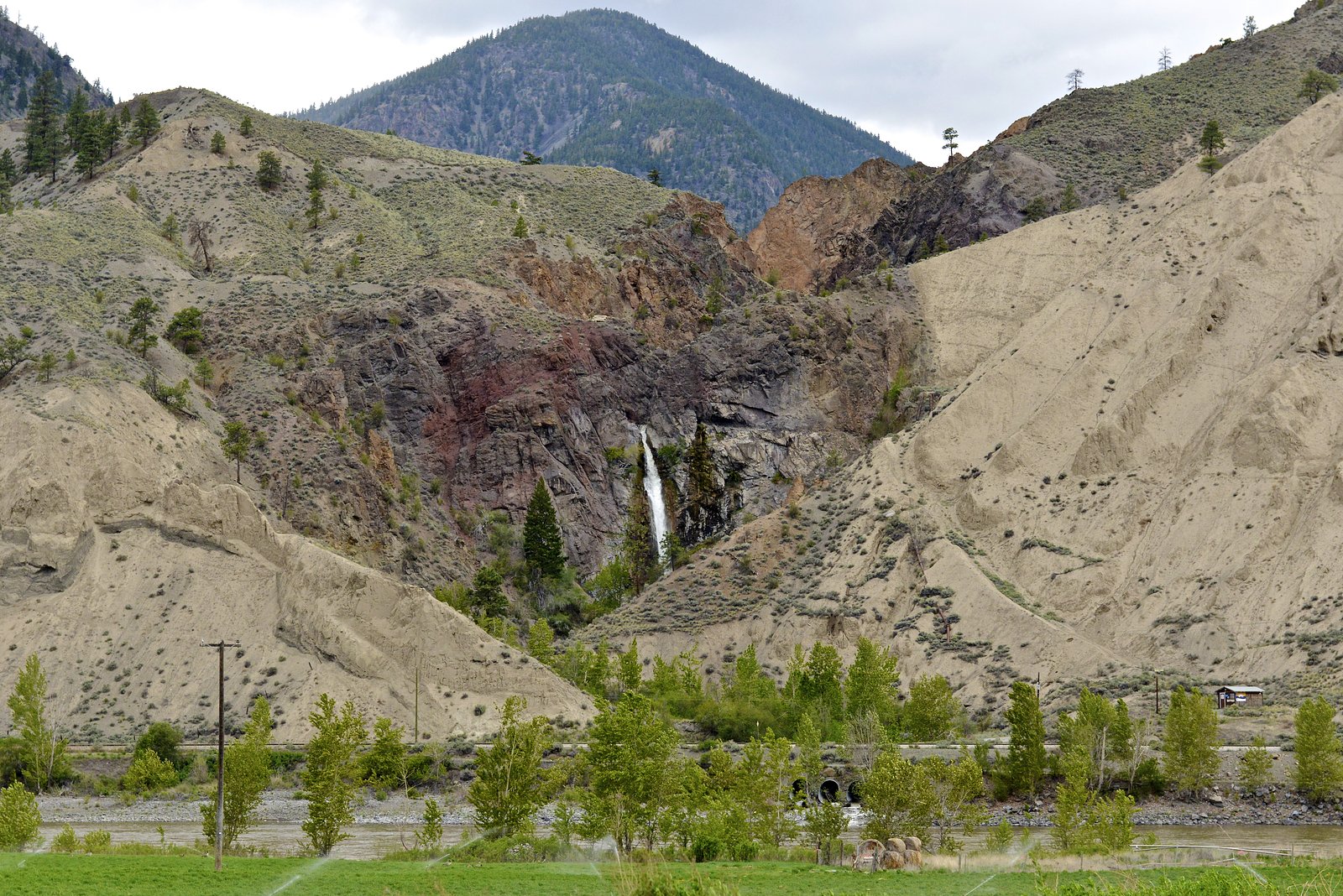
Photo Credits (4)
Difficulty
Easy
Trail Length
1.0 km
Trail Type
Out And Back
Elevation Gain
50 m
About Murray Creek Falls
Murray Creek Falls is a small, seasonal cascade on Murray Creek in interior British Columbia located near the coordinates 50.419, -121.3633 (roughly between Lillooet and Kamloops). Visitor reports and satellite imagery suggest the falls are a relatively modest drop set in a wooded or canyon stretch of the creek. Flow is typically highest in spring and early summer from snowmelt and after heavy rain; flows may be reduced to a trickle in late summer and early fall. Facilities are minimal or non-existent and access appears to be via a short spur or forest/secondary road rather than a developed provincial-park trail.
The Setting
Murray Creek Falls sits at 312 metres in the foothills of British Columbia. At 49 metres, it is among the taller waterfalls in British Columbia.
Why This Waterfall Exists
Murray Creek Falls flows over loose river sediment, primarily alluvium, laid down about 3 million years ago. These soft rocks erode readily, allowing the stream to carve a 160-foot drop into the landscape.
Trail & Hike Details
The Approach
The easy 1.0-km out-and-back trail gains 50 metres of elevation on the way to the falls.
Trail Description
There does not appear to be a heavily developed or signed trail to Murray Creek Falls. Visitors report reaching viewpoints by walking a short distance from a roadside pullout or along an unmaintained spur/forestry road. Expect uneven, natural terrain with roots, rocks and potentially steep or slippery sections near the creek and falls. If you plan to approach the base of the falls, route-finding and basic scrambling may be required.
What to Expect
The falls plunge 49 metres over loose river sediment.
Accessibility
The trail is short and relatively flat, but the surface may be uneven. Contact the managing agency for accessibility details.
Frequently Asked Questions
🐶 Are Dogs Allowed at Murray Creek Falls?
❌ Dogs are not allowed
Are There Any Fees or Permits Required?
🆖 No fees required
🏊 Is There Swimming at Murray Creek Falls?
❌ Swimming is not allowed
When to Visit
Late spring to early summer (May–June) is typically best for water volume because of snowmelt. Summer can be drier and flows may be reduced; fall offers cooler weather and fall colour but potentially lower flows. Winter access may be limited by snow and icy roads and the falls may be partly frozen.
Seasonal Access
The best time to visit is Spring, Summer, Fall, and Winter. Check with the managing park or local authority for current conditions.
Safety Information
Hazards include slippery rocks, steep or unstable creek banks, swift water near the falls, seasonal high flows during spring melt, and limited or no railings/guardrails. Roads may be rough and subject to seasonal closures; cell coverage can be unreliable. If visiting, go during daylight, wear appropriate footwear, and avoid getting too close to the lip or base of the falls where rockfall or sudden surges can occur.
Current Water Conditions
1,070.0 m³/s
Current discharge — how much water is flowing
Much lower than usual for this time of year
Based on 73 years of record
3.62 m
Water depth at gauge
7-Day Discharge Trend
What does this mean for your visit?
Flow is well below normal for this time of year, so the waterfall may be a trickle.
About This Gauge
7-Day Flow Outlook
Based on the WSC gauge THOMPSON RIVER NEAR SPENCES BRIDGE (7 km away).
Today
Barely Flowing
1070 m³/s
5/10Tomorrow
Barely Flowing
1042 m³/s
4/10Tue
Barely Flowing
1035 m³/s
4/10Wed
Barely Flowing
1013 m³/s
4/10Thu
Barely Flowing
999 m³/s
4/10Fri
Barely Flowing
971 m³/s
4/10Sat
Barely Flowing
964 m³/s
4/10Best window: Today — barely flowing flow, mainly sunny (trip score 5/10).
Best time of year: this gauge typically runs highest from early May to early August, peaking in June.
How we calculate this
This is a transparent outlook, not a precise forecast. We take the waterfall's current flow strength (how it ranks against its historical normal for today, from the nearest WSC stream gauge), carry that ranking forward along the gauge's seasonal curve, and nudge it for forecast rain. Confidence is highest for the next day or two and falls further out. Always check official conditions and your own judgment before visiting — high flows can be dangerous.
Know when to go.
Get a free email alert when waterfalls near Lillooet hit peak flow. We only send when conditions are worth the trip — no weekly newsletters, no spam.
Weather Forecast
Location & Access
Getting There
The falls are in a remote interior-BC setting roughly 37 miles from Lillooet and about 55.7 miles from Kamloops (driving distances approximate). Access may be by paved highway to a secondary/forestry road followed by a short walk. Expect limited signage; use the provided coordinates (50.419, -121.3633) and a reliable map or GPS. Roads in the area can be rough and may require high-clearance or 4x4 vehicles when on unpaved sections.
Get Directions on Google MapsParking
No formal parking lot is known. Parking likely consists of roadside/shoulder parking or a small informal pullout near a forest/secondary road. Park well off the road to avoid blocking traffic. If parking on a logging road, be aware of gated/seasonal closures and active forestry operations.
Elevation
312 metres above sea level
Coordinates
50.419033° N, -121.363289° W
Visitor Tips & Gear
• Treat the area as remote: tell someone your plans and expected return time. • Wear sturdy, waterproof footwear; rocks near the water are likely slippery. • Bring a map, compass/GPS and extra water, trailheads and pullouts may not be signed. • Be cautious of seasonal road conditions; a high-clearance vehicle may be helpful on unpaved approaches. • Observe all posted signs and closures related to forestry operations. • Practice Leave No Trace: pack out garbage and avoid damaging vegetation or creek banks. • If wildlife is encountered (bears, cougars), follow standard safety protocols (make noise, keep distance, carry bear spray where appropriate).
As an Amazon Associate, we earn from qualifying purchases.
For this easy 1.0 km trail, lightweight trail shoes and a water bottle are usually sufficient. Icy conditions are common in winter — traction cleats are a smart addition.

Columbia Watertight II Rain Jacket
Packs into its own pocket, seam-sealed, and keeps you dry from spray and surprise rain.

Polarized Sunglasses (Knockaround)
Cuts glare off the water so you actually see the falls — and your photos turn out better too.

Earth Pak Waterproof Dry Bag
Keeps your phone and gear dry when waterfall mist soaks everything else.

Waterproof Phone Pouch (AiRunTech)
Cheap insurance — take photos right next to the falls without killing your phone.

Kahtoola MICROspikes
Cult-favorite traction cleats that grip ice and wet rock — essential for winter waterfall hikes.

JOBY GorillaPod Starter Kit
Wraps around railings and rocks for long-exposure waterfall shots — no flat surface needed.
Where to Stay
Browse vacation cabins and private rentals nearby
Unique outdoor stays — tents, yurts, and treehouses
Rent a campervan or RV for your waterfall road trip
Some links are affiliate links. We may earn a commission at no extra cost to you.
Nearby Campground
Cal Woods Recreation Reserve
2 km away
Additional Information
Nearby Attractions
Nearest towns are Lillooet (~37 miles) and Kamloops (~56 miles) which offer services and accommodations. Other regional attractions may include lakes, provincial parks and scenic drives typical of the interior-B.C. region; confirm specific nearby parks and trails with local tourism or government sources.
Wildlife
Typical interior-BC species may be present: black bears, deer, mule/white-tailed deer, small mammals, and raptors. Be aware of snakes and insects in warm months.
Cities near Murray Creek Falls
Writing about Murray Creek Falls? Embed this waterfall on your site for free.