Photo Credits (1)
About Misery Falls
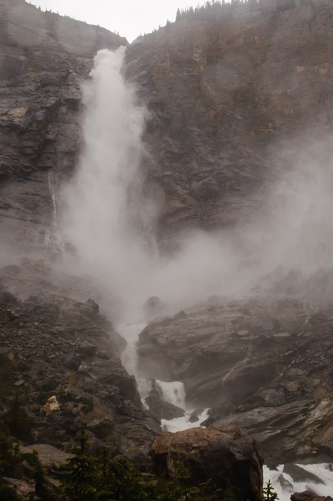
Misery Falls is a small coastal waterfall located on southern Vancouver Island, British Columbia (coords: 49.6782, -123.5855). It sits in a forested, coastal landscape within the general region served by Nanaimo and regional forest roads. Specifics about trail length, official facilities, and the measured vertical drop are not well documented in major trail guides; the falls appear to be a modest cascade that is most impressive during the wet season. Visitors should treat details here as approximate and verify local sources or recent trip reports before travel.
Why This Waterfall Exists
Misery Falls flows over hard intrusive rock laid down about 66-101 million years ago. These resistant rocks form a durable ledge that water cannot easily wear away, creating the falls where softer material downstream has already eroded.
Trail & Hike Details
Trail Description
Approach routes are typically along an unmaintained footpath through coastal mixed forest (Douglas‑fir/hemlock, depending on location). Trails in this area often have roots, rocks and short steep sections; expect a rough, possibly muddy approach. There is likely limited or no signage, and the final viewpoint may require stepping onto rocks near the stream. Trail markers, boardwalks or railings are not expected.
What to Expect
A modest forested cascade rather than a large, dramatic waterfall. Flow will be highest in late fall through spring (after rain) and lower during the dry summer months. No formal viewing platforms, restrooms, or trash facilities are expected. Cell coverage may be limited in forested or valley areas. Insects (mosquitoes/blackflies) can be a nuisance in warm months.
Accessibility
Not wheelchair or stroller accessible. Trails are likely uneven, narrow and may include short steep or slippery sections.
Frequently Asked Questions
🐶 Are Dogs Allowed at Misery Falls?
❌ Dogs are not allowed
Are There Any Fees or Permits Required?
🆖 No fees required
🏊 Is There Swimming at Misery Falls?
❌ Swimming is not allowed
When to Visit
Late fall through spring for the strongest flows; early morning or weekdays for fewer visitors. Summer offers easier road conditions but lower water flow. Avoid visiting after heavy rain without checking road safety and conditions.
Seasonal Access
The best time to visit is Spring, Summer, Fall, and Winter. Check with the managing park or local authority for current conditions.
Safety Information
Hazards include slippery rocks and roots, steep and unstable edges near the falls, fast-flowing water during high runoff, limited cell reception, changing weather, biting insects, and the potential presence of bears and other wildlife. Do not approach cliff edges or stand on wet rocks. Check recent trip reports or local land manager advisories before visiting. If accessing by forest service roads, be aware roads may be gated, rough, or seasonally impassable.
Current Water Conditions
10.6 m³/s
Current discharge — how much water is flowing
Lower than usual for this time of year
Based on 33 years of record
2.96 m
Water depth at gauge
7-Day Discharge Trend
What does this mean for your visit?
Flow is lower than usual for this time of year.
About This Gauge
This gauge is on a nearby waterway and may not reflect exact conditions at the falls.
7-Day Flow Outlook
Based on the WSC gauge CLOWHOM RIVER NEAR CLOWHOM LAKE (17 km away).
Today
Low
11 m³/s
6/10Tomorrow
Low
11 m³/s
5/10Tue
Low
10 m³/s
5/10Wed
Low
10 m³/s
5/10Thu
Low
11 m³/s
5/10Fri
Low
12 m³/s
4/10Sat
Low
11 m³/s
4/10Best window: Today — low flow, sunny (trip score 6/10).
Best time of year: this gauge typically runs highest from early May to late July, peaking in June.
How we calculate this
This is a transparent outlook, not a precise forecast. We take the waterfall's current flow strength (how it ranks against its historical normal for today, from the nearest WSC stream gauge), carry that ranking forward along the gauge's seasonal curve, and nudge it for forecast rain. Confidence is highest for the next day or two and falls further out. Always check official conditions and your own judgment before visiting — high flows can be dangerous.
Know when to go.
Get a free email alert when waterfalls near Nanaimo hit peak flow. We only send when conditions are worth the trip — no weekly newsletters, no spam.
Weather Forecast
Location & Access
Getting There
Misery Falls is reached from the general Nanaimo / southern Vancouver Island area. Use the provided coordinates (49.6782, -123.5855) in a GPS mapping app. Access likely requires travel on secondary or forest access roads and a short informal footpath through forest; there is no well‑signed provincial park entrance known from major sources. Expect unpaved roads and an unmarked or minimally marked trailhead.
Get Directions on Google MapsParking
Parking is likely informal roadside or at an unpaved pullout near the trailhead. There does not appear to be a maintained parking lot or formal facilities. Park legally and avoid blocking gates or driveways.
Elevation
54 metres above sea level
Coordinates
49.678209° N, -123.585495° W
Visitor Tips & Gear
1) Use the coordinates and a reliable mapping app or recent trip report to locate the trailhead. 2) Wear sturdy, grippy footwear, rocks and roots near the falls can be slippery. 3) Bring insect repellent and layered clothing for coastal weather. 4) Park legally in designated areas or pullouts; do not block gates. 5) Exercise caution near edges and wet rocks; keep a safe distance from the lip and cascades. 6) Follow Leave No Trace principles and pack out all trash. 7) If travelling on forest service/logging roads, be aware of gated or seasonal closures and watch for vehicles.
Where to Stay
Browse vacation cabins and private rentals nearby
Unique outdoor stays — tents, yurts, and treehouses
Rent a campervan or RV for your waterfall road trip
Some links are affiliate links. We may earn a commission at no extra cost to you.
Nearby Campground
Nine Mile Point
17.2 km away
Additional Information
Nearby Attractions
Regional attractions include the city of Nanaimo (approximate regional reference), coastal viewpoints and regional trails on southern Vancouver Island. The falls are also within reach of other island outdoor recreation areas; check local tourism and park resources for up‑to‑date nearby sites.
Wildlife
Expect typical coastal Vancouver Island wildlife: black bear, deer, small mammals, and a variety of birds (including eagles and shorebirds near coastal areas). Salmon may use nearby streams in season where suitable spawning habitat exists, but this depends on the specific stream. Practice wildlife safety and store food securely.
Cities near Misery Falls
Writing about Misery Falls? Embed this waterfall on your site for free.