Difficulty
Drive Up
Trail Length
0.2 km
Trail Type
Out And Back
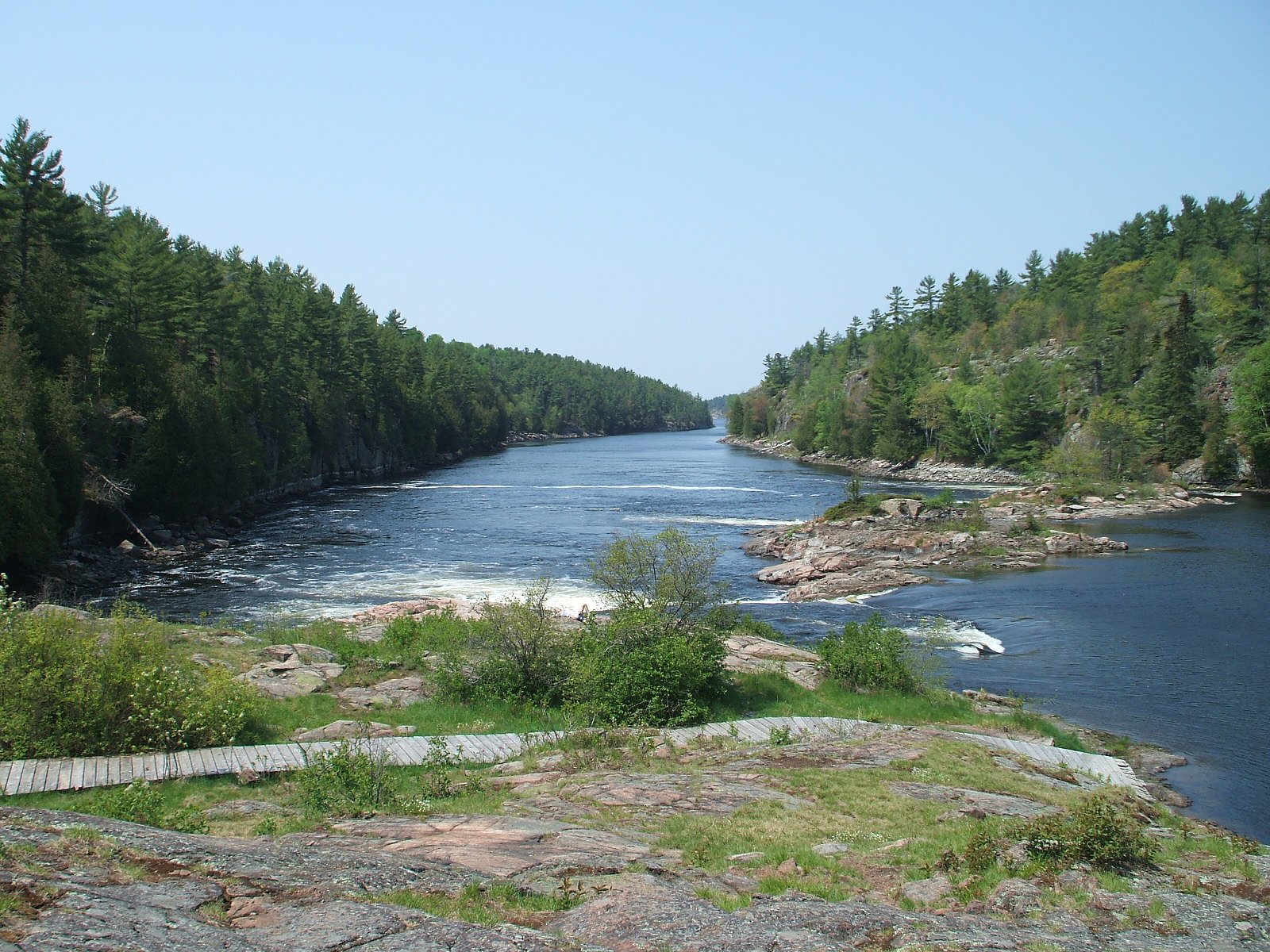
About Meshaw Falls
Meshaw Falls is a small, forested cascade in central Ontario near the Sudbury/Parry Sound region. At the provided coordinates it appears to be a modest waterfall on a local stream cutting through mixed hardwood and conifer forest. Information about official trail infrastructure and exact vertical drop is limited; descriptions below use cautious language where details are uncertain.
Why This Waterfall Exists
Meshaw Falls flows over hard metamorphic rock, primarily migmatite and gneiss, laid down over 1.0-1.6 billion years ago. These resistant rocks form a durable ledge that water cannot easily wear away, creating the falls where softer material downstream has already eroded.
Nearby Falls Worth Visiting
Recollet Falls (2 m) lies 4.5 kilometres to the southwest.
Trail & Hike Details
The Approach
No hiking required. Meshaw Falls is accessible by vehicle with a roadside viewing area.
Trail Description
Detailed, authoritative trail descriptions for Meshaw Falls are not readily available. Reports for similar small, off-the-beaten-path falls in this part of Ontario commonly describe a short unmarked trail from a roadside parking/pullout leading through mixed forest to a creek or gorge. Expect uneven terrain with roots and rocks, possible short steep sections to reach the stream edge, and limited or no maintained boardwalks or railings. Follow cairns or faint boot paths where present, and treat routes across wet rock as slippery.
What to Expect
A modest cascade in a wooded setting; seasonal flow can vary widely (high in spring runoff, lower in late summer/fall). Likely no visitor facilities (toilets, benches), limited signage, and minimal maintenance. Expect mossy rock slabs, wet surfaces, and typical boreal/mixed-wood vegetation. Wildlife encounters (deer, small mammals, birds, and possibly black bears or moose) are possible in the region. Cell service may be spotty.
Accessibility
This waterfall is viewable from a vehicle-accessible area. No hiking is required.
Frequently Asked Questions
🐶 Are Dogs Allowed at Meshaw Falls?
❌ Dogs are not allowed
Are There Any Fees or Permits Required?
🆖 No fees required
🏊 Is There Swimming at Meshaw Falls?
❌ Swimming is not allowed
When to Visit
Spring (late March–May) usually yields the highest flows and most impressive water levels. Summer and early fall offer more stable access and nicer weather; fall also provides good foliage color. Winter can produce scenic ice formations but expect icy, hazardous access and possibly closed or impassable forestry roads, only attempt winter visits if properly equipped and experienced in winter travel.
Seasonal Access
The best time to visit is Spring, Summer, Fall, and Winter. Check with the managing park or local authority for current conditions.
Safety Information
• Slippery rock and steep, unstable edges: exercise extreme caution near the water and keep a safe distance from the lip of falls and undercut banks. • Variable flow: water levels change seasonally; heavy rain or spring melt can increase flows and make crossing streams dangerous. • Limited services: bring supplies; emergency response may take time in remote areas. • Wildlife: practice bear and moose safety. Keep food sealed and unattended items stored securely. • Road conditions: forestry and secondary roads can be rough, narrow, or seasonally closed, low-clearance vehicles may be at risk. • If uncertain about conditions, check with local authorities, park offices, or recent trip reports before visiting.
Current Water Conditions
46.7 m³/s
Current discharge — how much water is flowing
About average for this time of year
Based on 64 years of record
0.55 m
Water depth at gauge
7-Day Discharge Trend
What does this mean for your visit?
Flow is about average for this time of year.
About This Gauge
7-Day Flow Outlook
Based on the WSC gauge FRENCH RIVER AT DRY PINE BAY (4 km away).
Today
Moderate
47 m³/s
6/10Tomorrow
Moderate
47 m³/s
6/10Tue
Moderate
49 m³/s
5/10Wed
Moderate
48 m³/s
5/10Thu
Moderate
43 m³/s
6/10Fri
Moderate
44 m³/s
5/10Sat
Moderate
42 m³/s
6/10Best window: Today — moderate flow, cloudy (trip score 6/10).
Best time of year: this gauge typically runs highest from early November to mid January, peaking in November.
How we calculate this
This is a transparent outlook, not a precise forecast. We take the waterfall's current flow strength (how it ranks against its historical normal for today, from the nearest WSC stream gauge), carry that ranking forward along the gauge's seasonal curve, and nudge it for forecast rain. Confidence is highest for the next day or two and falls further out. Always check official conditions and your own judgment before visiting — high flows can be dangerous.
Know when to go.
Get a free email alert when waterfalls near Sudbury hit peak flow. We only send when conditions are worth the trip — no weekly newsletters, no spam.
Weather Forecast
Location & Access
Getting There
The falls are located near latitude 46.0484, longitude -80.5694, roughly 39 miles from Greater Sudbury and about 58 miles from Parry Sound. Access likely requires driving on secondary provincial roads and possibly on short stretches of unpaved or forestry roads. Expect to leave the main highway and follow local roads; GPS or a detailed regional map is recommended. Cell coverage may be intermittent in parts of this region.
Get Directions on Google MapsParking
No formal parking lot is known to be provided. Parking may be a roadside pullout or an informal space at the trailhead; park clear of lanes and private driveways. If you encounter signage or a designated lot, follow posted rules. Visitors should be prepared for limited facilities (no toilet, no potable water) unless noted on local resources.
Elevation
199 metres above sea level
Coordinates
46.048435° N, -80.569413° W
Visitor Tips & Gear
• Wear sturdy, grippy footwear, wet rock and roots are common and slippery. • Check recent trip reports or local resources for road and trail conditions; unpaved access roads may be rough. • Bring a map and inform someone of your plans if heading into remote forested areas; cell coverage may be limited. • Be bear-aware: store food securely and make noise while hiking. Carry bear spray if you are comfortable using it and know local regulations. • Respect private property and posted signs; do not trespass on timber or private lands. • Avoid walking on fragile stream banks and vegetation; stay back from edges where banks may be undercut.
Where to Stay
Browse vacation cabins and private rentals nearby
Unique outdoor stays — tents, yurts, and treehouses
Rent a campervan or RV for your waterfall road trip
Some links are affiliate links. We may earn a commission at no extra cost to you.
Nearby Campground
B6
11.2 km away
Additional Information
Nearby Attractions
The area between Sudbury and Parry Sound includes provincial lakes, rivers, and crown land popular for boating, fishing, and backcountry exploration. French River Provincial Park and other lakes and rivers are in the broader region, but exact proximity should be verified on a regional map based on the coordinates given.
Wildlife
Typical wildlife for central Ontario forests: white-tailed deer, moose (in some areas), black bear, beavers, otters, and numerous bird species including waterfowl and songbirds. Ticks and mosquitoes can be common in warmer months.
Cities near Meshaw Falls
Nearby Waterfalls
Writing about Meshaw Falls? Embed this waterfall on your site for free.