
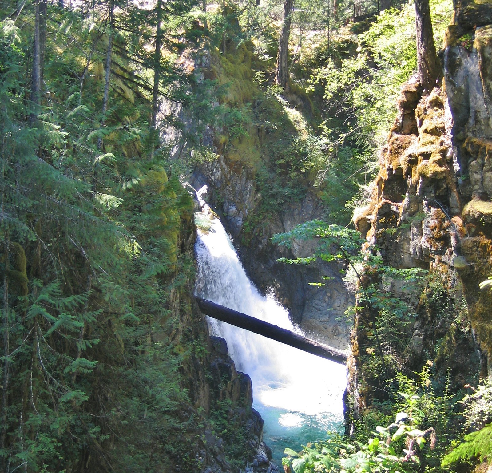
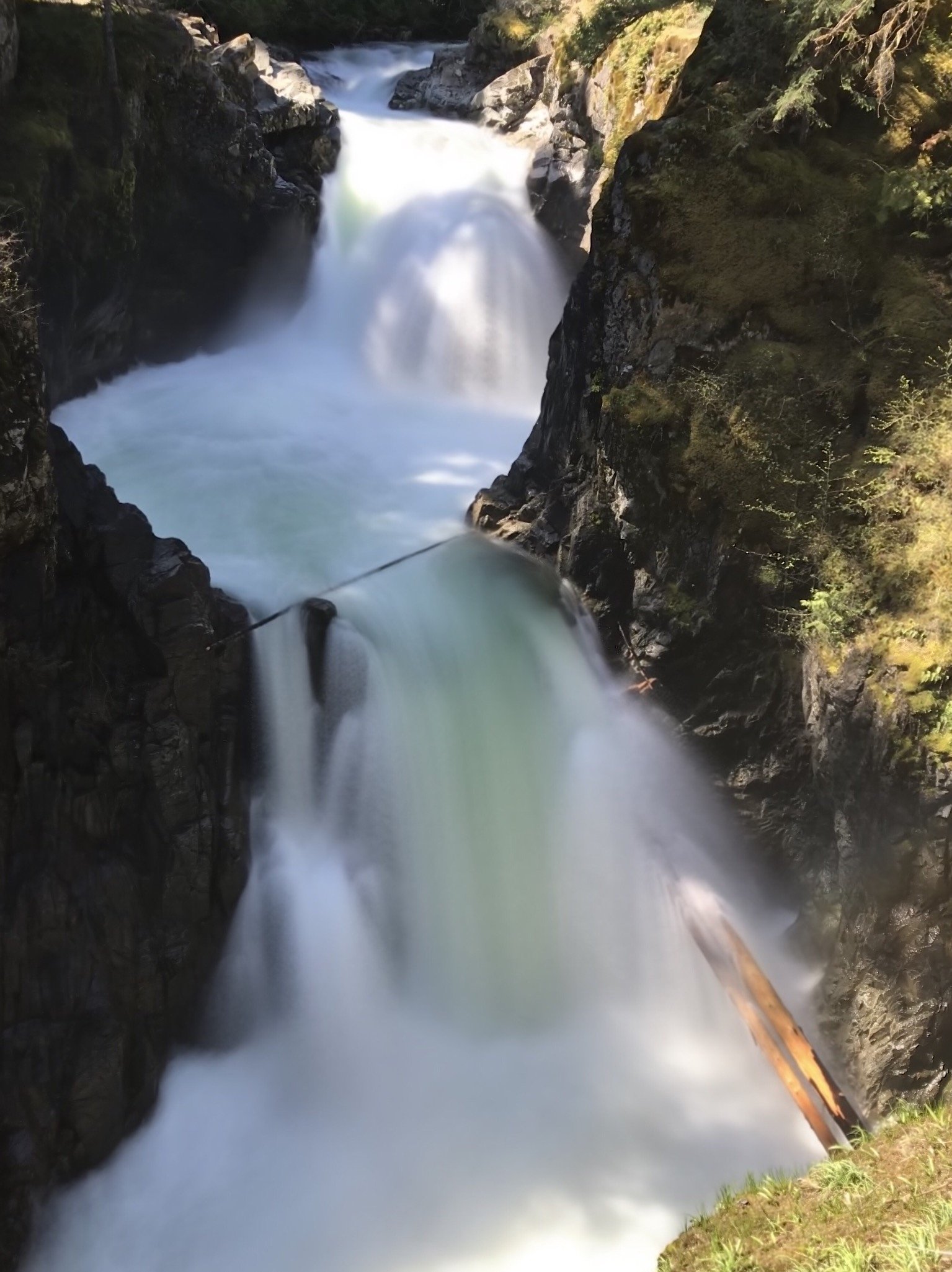
Lower Waterfall
British Columbia • Little Qualicum Falls Park • 5 m
By Armen Suny · Last verified Jun 2026
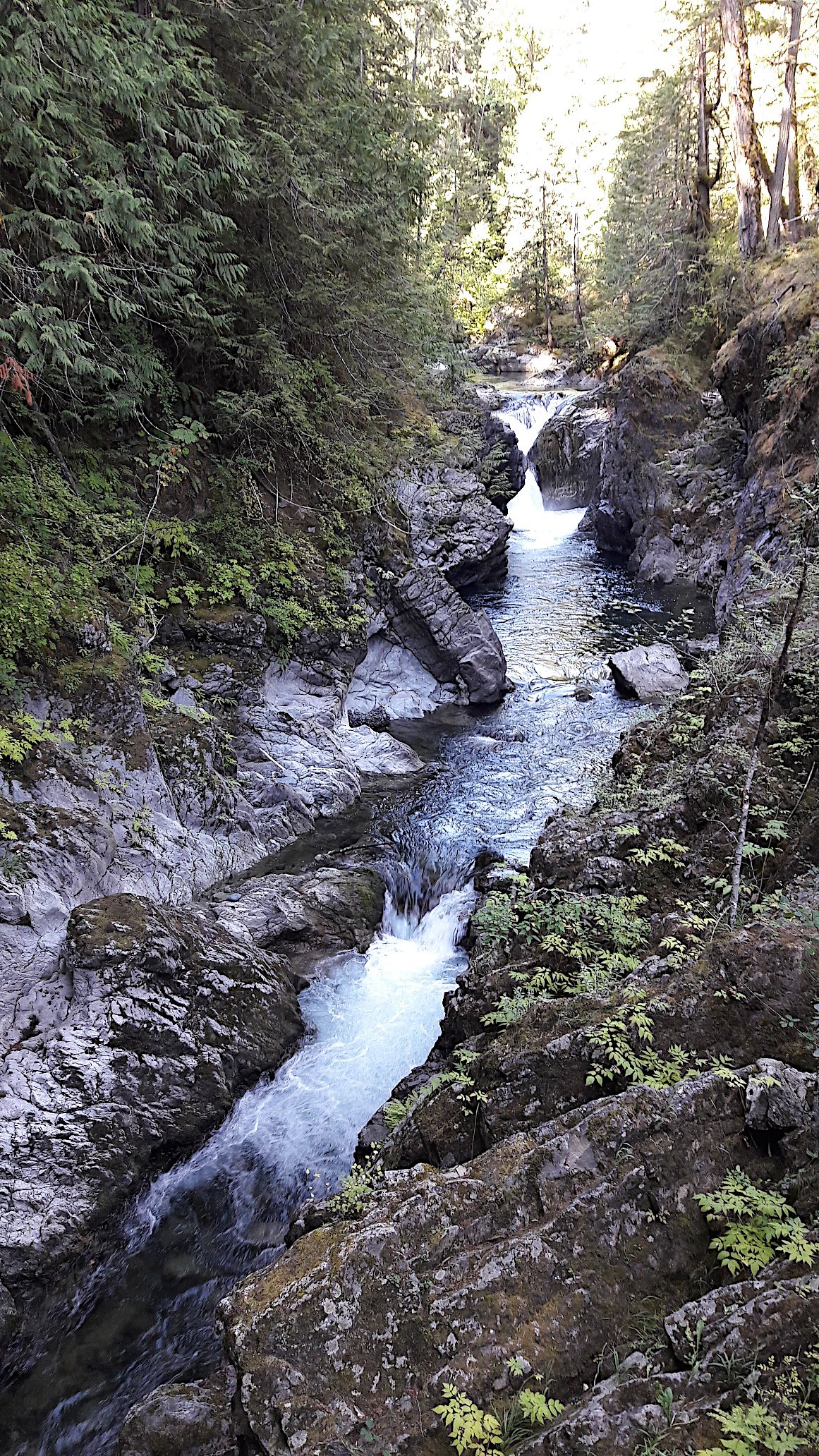
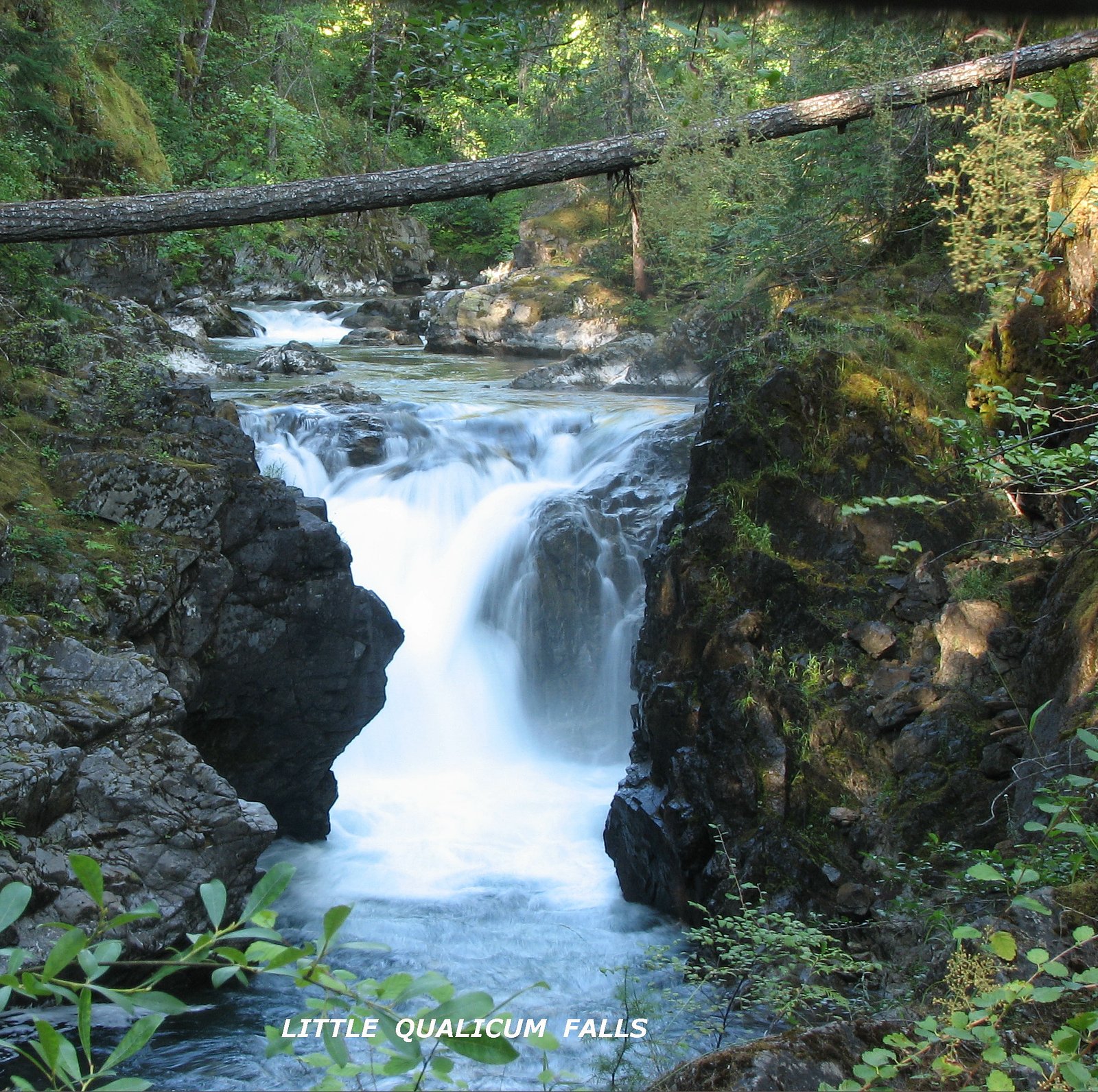
Photo Credits (5)
Difficulty
Easy
Trail Length
3.1 km
Trail Type
Loop
Elevation Gain
43 m
About Lower Waterfall
Lower Waterfall is a coastal-BC cascade located on the northern Sunshine Coast near Powell River (coordinates 49.3161, -124.5563). It appears to be a smaller, forested multi-step cascade rather than a single large plunge. Flow and appearance are seasonal and typically strongest in spring and after heavy rains; specific published height and official route information are not available in major trail databases, so details below are conservative and may require local confirmation.
The Setting
Lower Waterfall sits at 130 metres within Little Qualicum Falls Park, in the coastal lowlands of British Columbia. The falls drop 5 metres.
Why This Waterfall Exists
Lower Waterfall flows over Island Plutonic Suite, a hard intrusive rock layer deposited about 162-201 million years ago. These resistant rocks form a durable ledge that water cannot easily wear away, creating a 16-foot drop where softer material downstream has already eroded.
Nearby Falls Worth Visiting
Englishman River Upper Falls (24 m) lies 17.1 kilometres to the east. Also nearby: Englishman River Falls (24 m, 17.1 km) and Upper Waterfall (17 m, 0.3 km).
Trail & Hike Details
The Approach
The easy 3.1-km loop trail gains 43 metres of elevation on the way to the falls.
Trail Description
Trailhead and route information are not consistently documented in major trail resources. Expect a natural forest trail that may be short but uneven, with roots, rocks, and possible wet/slippery sections. The trail may follow or cross small streams and could include unmarked or rough sections. Use a map/GPS and recent local trip reports to confirm the route.
What to Expect
The falls drop a gentle 5 metres over hard intrusive rock.
Accessibility
The trail is not wheelchair accessible. Uneven terrain and elevation changes require steady footing.
Frequently Asked Questions
🐶 Are Dogs Allowed at Lower Waterfall?
❌ Dogs are not allowed
Are There Any Fees or Permits Required?
🆖 No fees required
🏊 Is There Swimming at Lower Waterfall?
❌ Swimming is not allowed
When to Visit
Spring (snowmelt and seasonal rains) for strongest flows; late spring and early summer for good combination of flow and milder weather. Summer offers drier trails and warmer conditions but lower flows. Fall can offer good flow and quieter access. Winter conditions may be wet, icy, or affected by logging-road closures.
Seasonal Access
The best time to visit is Spring, Summer, and Fall. Winter access may be limited. Check with Little Qualicum Falls Park for current conditions.
Safety Information
Major hazards include slippery rocks and wet banks, sudden high flows after rain, unmarked or poorly maintained trails, limited cell service, and seasonal logging activity on access roads. Do not climb on wet rocks near the falls. Tell someone your plan, check weather and local advisories, and carry basic safety gear. If hiking in bear country, carry bear spray and know how to use it.
Current Water Conditions
1.7 m³/s
Current discharge — how much water is flowing
Much lower than usual for this time of year
Based on 37 years of record
4.83 m
Water depth at gauge
7-Day Discharge Trend
What does this mean for your visit?
Flow is well below normal for this time of year, so the waterfall may be a trickle.
About This Gauge
7-Day Flow Outlook
Based on the WSC gauge LITTLE QUALICUM RIVER NEAR QUALICUM BEACH (7 km away).
Today
Barely Flowing
1.7 m³/s
4/10Tomorrow
Barely Flowing
1.7 m³/s
5/10Tue
Barely Flowing
1.6 m³/s
4/10Wed
Barely Flowing
1.6 m³/s
4/10Thu
Barely Flowing
1.5 m³/s
4/10Fri
Barely Flowing
1.5 m³/s
4/10Sat
Barely Flowing
1.3 m³/s
4/10Best window: Tomorrow — barely flowing flow, sunny (trip score 5/10).
Best time of year: this gauge typically runs highest from early November to late December, peaking in January.
How we calculate this
This is a transparent outlook, not a precise forecast. We take the waterfall's current flow strength (how it ranks against its historical normal for today, from the nearest WSC stream gauge), carry that ranking forward along the gauge's seasonal curve, and nudge it for forecast rain. Confidence is highest for the next day or two and falls further out. Always check official conditions and your own judgment before visiting — high flows can be dangerous.
Know when to go.
Get a free email alert when waterfalls near Powell River hit peak flow. We only send when conditions are worth the trip — no weekly newsletters, no spam.
Weather Forecast
Location & Access
Getting There
General approach is from the Powell River area via Highway 101 (Sunshine Coast Highway) and then local/forest service roads or trails. Exact trailhead location and access route are not confirmed; some approaches to waterfalls in this region require driving on unpaved forestry roads and a short hike through coastal forest. Confirm driveway/road access and recent trip reports before travel.
Get Directions on Google MapsParking
Parking is likely limited to a small trailhead pullout or roadside parking. There may be no formal lot, signage, or facilities. Park legally and avoid blocking gates or private driveways.
Elevation
130 metres above sea level
Coordinates
49.316143° N, -124.556346° W
Land Management
Managed by Government of British Columbia
Visitor Tips & Gear
1) Wear sturdy, closed-toe footwear with good traction. 2) Check recent trip reports, local ranger or forest service info, and maps before heading out. 3) Be prepared for unmarked or minimally maintained trails; bring a GPS or offline map. 4) Park responsibly and respect private property, some access routes in this region cross or abut private land and forestry operations. 5) Avoid approaching the water edge after heavy rain due to strong currents and slippery banks.
As an Amazon Associate, we earn from qualifying purchases.
This easy 3.1 km hike is straightforward — comfortable trail shoes and plenty of water should do. Sun exposure on the trail makes good sun protection a must in summer.

Polarized Sunglasses (Knockaround)
Cuts glare off the water so you actually see the falls — and your photos turn out better too.

Columbia Watertight II Rain Jacket
Packs into its own pocket, seam-sealed, and keeps you dry from spray and surprise rain.

Earth Pak Waterproof Dry Bag
Keeps your phone and gear dry when waterfall mist soaks everything else.

Waterproof Phone Pouch (AiRunTech)
Cheap insurance — take photos right next to the falls without killing your phone.

JOBY GorillaPod Starter Kit
Wraps around railings and rocks for long-exposure waterfall shots — no flat surface needed.

Osprey Daylite Daypack
Light, organized, and just the right size for a day hike — fits water, snacks, and layers.
Where to Stay
Browse vacation cabins and private rentals nearby
Unique outdoor stays — tents, yurts, and treehouses
Rent a campervan or RV for your waterfall road trip
Some links are affiliate links. We may earn a commission at no extra cost to you.
Nearby Campground
Little Qualicum Falls - Upper Campground
0.7 km away
Additional Information
Nearby Attractions
Powell River (townsite and amenities), Inland Lake Provincial Park, Savary Island (seasonal access), Lund and the northern Sunshine Coast communities; nearby provincial parks and backcountry trails may be of interest. Exact distances vary, confirm local maps for routing.
Wildlife
Typical coastal-BC species may be present: black bear, cougar (rare but present), black-tailed deer, bald eagles, various waterfowl and shorebirds, and salmon in spawning streams (seasonal). Practice wildlife safety and store food appropriately.
Cities near Lower Waterfall
Nearby Waterfalls

Writing about Lower Waterfall? Embed this waterfall on your site for free.