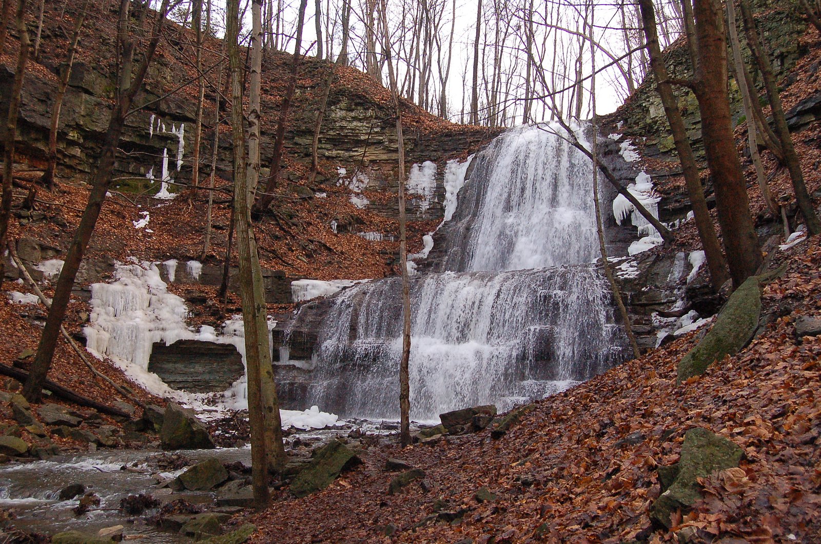
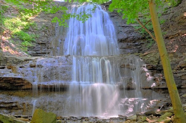
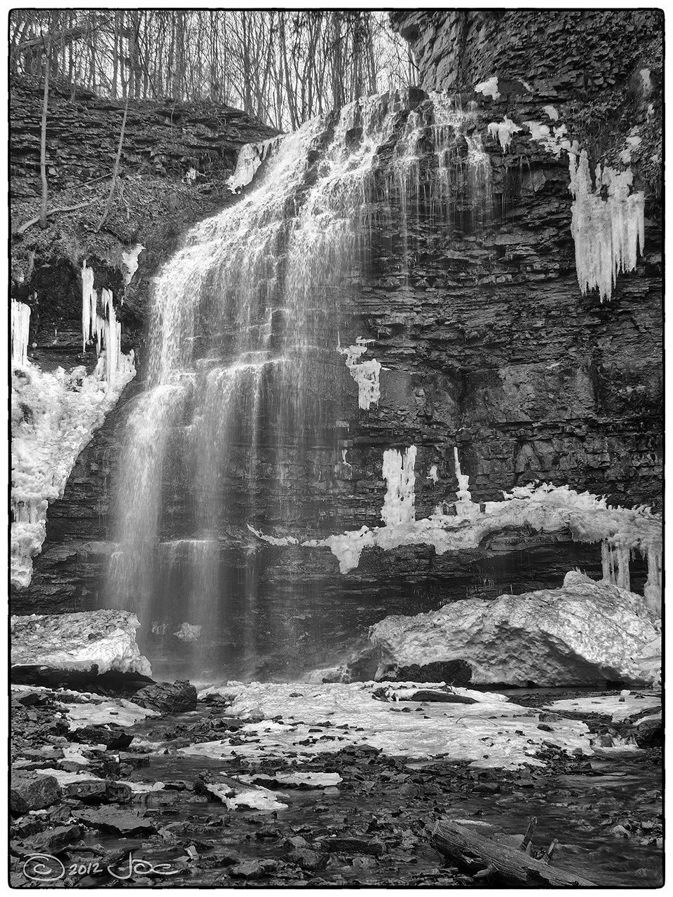
Lower Little Falls
Ontario • 8 m
By Armen Suny · Last verified Jun 2026
Difficulty
Moderate
Trail Length
3.7 km
Trail Type
Out And Back
Elevation Gain
96 m
About Lower Little Falls
Lower Little Falls sits among Hamilton’s famous collection of more than 100 waterfalls along the Niagara Escarpment, a dramatic limestone ridge that UNESCO recognizes as a World Biosphere Reserve. The falls are reached via short viewing approaches from the escarpment's network of footpaths and draw hikers who enjoy the mix of wooded canyon scenery and accessible vantage points. The setting reflects the same geology that creates cascades from Tobermory to Niagara Falls, making it an easy stop on a broader Bruce Trail outing. The approach to the falls is inviting for a daytime visit: expect a rustic, natural setting rather than developed facilities. The trail to the main viewpoints offers a compact outdoor experience, great for photographers and families who want a quick dose of escarpment scenery without a long backcountry commitment. There are no formal campgrounds within 10 km of Lower Little Falls, so plan this as a day hike and arrive with sturdy footwear and basic trail navigation in mind.
The Setting
Lower Little Falls sits at 168 metres in the foothills of Ontario. The falls drop 8 metres.
Height: 27 feet
Nearby Falls Worth Visiting
Tiffany Falls (21 m) lies 0.6 kilometres to the east. Also nearby: Sherman Falls (17 m, 0.6 km) and Ancaster Heights Falls (13 m, 0.2 km).
Trail & Hike Details
The Approach
The moderate 3.7-km out-and-back trail gains 96 metres of elevation on the way to the falls.
Trail Description
A short, relatively easy walk from nearby parking leads to viewing points for the falls. The path may be narrow in places, with roots, rocks, and occasional steep or muddy sections. Expect informal footpaths and some low ledge-scrambling to reach the best vantage points. Trails are likely unpaved and can become slippery when wet or icy.
What to Expect
The falls drop 8 metres.
Accessibility
The trail is not wheelchair accessible. Uneven terrain and elevation changes require steady footing.
Frequently Asked Questions
🐶 Are Dogs Allowed at Lower Little Falls?
❌ Dogs are not allowed
Are There Any Fees or Permits Required?
🆖 No fees required
🏊 Is There Swimming at Lower Little Falls?
❌ Swimming is not allowed
When to Visit
Spring (for higher flows and vibrant green growth) and fall (for foliage) are best for photography and viewing; winter offers ice formations but is more hazardous. Avoid very dry late-summer periods if you want strong water flow.
Seasonal Access
The best time to visit is Spring, Summer, Fall, and Winter. Check with the managing park or local authority for current conditions.
Safety Information
Common hazards include slippery and unstable rock near the falls, steep drop-offs, strong currents in high flow conditions, falling or loose rocks, seasonal ice, and ticks. Do not attempt to climb wet rock faces or stand right at the edge. Supervise children closely. Check local conditions and weather before visiting and avoid visiting alone in remote or poorly signposted areas. If the area appears to be on or adjacent to private property, do not trespass.
Current Water Conditions
0.0 m³/s
Current discharge — how much water is flowing
Lower than usual for this time of year
Based on 33 years of record
0.11 m
Water depth at gauge
7-Day Discharge Trend
What does this mean for your visit?
Flow is lower than usual for this time of year.
About This Gauge
7-Day Flow Outlook
Based on the WSC gauge ANCASTER CREEK AT ANCASTER (1 km away).
Today
Low
0.0 m³/s
5/10Tomorrow
Low
0.0 m³/s
5/10Tue
Moderate
0.0 m³/s
4/10Wed
Moderate
0.0 m³/s
6/10Thu
Low
0.0 m³/s
5/10Fri
Moderate
0.0 m³/s
5/10Sat
Moderate
0.0 m³/s
5/10Best window: Wed — moderate flow, cloudy (trip score 6/10).
Best time of year: this gauge typically runs highest from early March to late May, peaking in April.
How we calculate this
This is a transparent outlook, not a precise forecast. We take the waterfall's current flow strength (how it ranks against its historical normal for today, from the nearest WSC stream gauge), carry that ranking forward along the gauge's seasonal curve, and nudge it for forecast rain. Confidence is highest for the next day or two and falls further out. Always check official conditions and your own judgment before visiting — high flows can be dangerous.
Know when to go.
Get a free email alert when waterfalls near Hamilton hit peak flow. We only send when conditions are worth the trip — no weekly newsletters, no spam.
Weather Forecast
Location & Access
Getting There
The falls are located near Hamilton (about 5–6 miles from downtown Hamilton), approximately 30–40 miles from Kitchener and Orangeville. Use the coordinates 43.2399, -79.9657 in a mapping app for the most direct route. Expect a short drive on local roads; final approach may be on a minor access road or conservation-area road depending on the exact access point.
Get Directions on Google MapsParking
Parking may be limited. There may be a small parking area or roadside parking nearby; visitors should use official parking areas where provided and avoid blocking private driveways or roads. If a nearby conservation area or park maintains a lot, prefer using that lot and follow posted rules and fees.
Elevation
168 metres above sea level
Coordinates
43.239945° N, -79.965700° W
Visitor Tips & Gear
Wear sturdy, waterproof footwear with good traction. Stay back from the edge of ledges and do not climb on wet rock. Respect private property signs, some access points near urban areas can border private land. Pack out all trash and avoid disturbing vegetation. Check local conservation authority or municipality for any temporary closures or trail advisories before visiting.
As an Amazon Associate, we earn from qualifying purchases.
With 3.7 km and 96 m of elevation gain, sturdy boots and trekking poles will help on this moderate trail. Icy conditions are common in winter — traction cleats are a smart addition.

Columbia Watertight II Rain Jacket
Packs into its own pocket, seam-sealed, and keeps you dry from spray and surprise rain.

Earth Pak Waterproof Dry Bag
Keeps your phone and gear dry when waterfall mist soaks everything else.

Waterproof Phone Pouch (AiRunTech)
Cheap insurance — take photos right next to the falls without killing your phone.

Timberland Euro Sprint Mid Waterproof
Trusted waterproof boot with premium leather and grippy rubber sole — reliable on rocky, wet trails.

TrailBuddy Trekking Poles
Lightweight aluminum, cork grips, and flip-locks that actually hold — a best-seller for good reason.

Kahtoola MICROspikes
Cult-favorite traction cleats that grip ice and wet rock — essential for winter waterfall hikes.
Where to Stay
Browse vacation cabins and private rentals nearby
Unique outdoor stays — tents, yurts, and treehouses
Rent a campervan or RV for your waterfall road trip
Some links are affiliate links. We may earn a commission at no extra cost to you.
Nearby Campground
Lost Forest Park & Camping Resort
16.2 km away
Additional Information
Nearby Attractions
The falls are in the broader Hamilton/Dundas area, which has numerous other waterfalls and conservation areas (for example, Spencer Gorge / Webster's Falls and Tew's Falls are in the general region). Check local visitor resources for other nearby hikes and viewpoints.
Wildlife
Expect typical southern Ontario wildlife: songbirds, small mammals (squirrels, raccoons), white-tailed deer in wooded areas, and insects including ticks. Be aware of poison ivy along trails and take precautions against ticks.
Cities near Lower Little Falls
Nearby Waterfalls
Other waterfalls named Lower Little Falls
1 other waterfall shares this name across Canada.
Writing about Lower Little Falls? Embed this waterfall on your site for free.