Lepreau Falls
New Brunswick • 8 m
By Armen Suny · Last verified Jun 2026
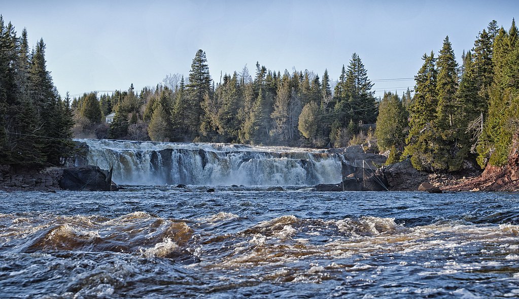
Photo Credits (5)
Difficulty
Easy
Trail Length
0.3 km
Trail Type
Out And Back
About Lepreau Falls
Lepreau Falls is a small, scenic waterfall on the Lepreau River in southwestern New Brunswick. The falls sit in a wooded river gorge and are most impressive during spring runoff and after heavy rain. Visitors report a short walk from a roadside parking area to viewpoints; the immediate area is natural and can be rocky and slippery.
The Setting
Lepreau Falls sits at 17 metres within 4010400, in the coastal lowlands of New Brunswick. The falls drop 8 metres.
Why This Waterfall Exists
Lepreau Falls flows over hard intrusive rock laid down about 485 million to 1.0 billion years ago. These resistant rocks form a durable ledge that water cannot easily wear away, creating a 26-foot drop where softer material downstream has already eroded.
Trail & Hike Details
Trail Description
A short, mostly flat walk from a small parking turnout through mixed forest to the river gorge and primary viewing area. The approach is typically under a half-mile round-trip, but the final section can be over roots and rocks and may be muddy after rain. There may be informal worn trails along the river; exercise caution near the edge.
What to Expect
The falls drop 8 metres over hard intrusive rock.
Accessibility
The trail is short and relatively flat, but the surface may be uneven. Contact the managing agency for accessibility details.
Frequently Asked Questions
🐶 Are Dogs Allowed at Lepreau Falls?
❌ Dogs are not allowed
Are There Any Fees or Permits Required?
🆖 No fees required
🏊 Is There Swimming at Lepreau Falls?
❌ Swimming is not allowed
When to Visit
Late spring (high flow) for the most impressive water volume; early summer for warmer weather and easier travel; fall for foliage colors. Avoid visiting right after heavy rainfall if you are not prepared for slippery conditions, and be cautious in winter when ice can make access hazardous.
Seasonal Access
The best time to visit is Spring, Summer, and Fall. Winter access may be limited. Check with the managing park or local authority for current conditions.
Safety Information
Hazards include slippery and unstable rocks near the river, strong currents during high flow, steep or undercut banks, and variable weather. In winter, ice-covered rocks and trails are extremely hazardous. Cell coverage may be limited, tell someone your plans and expected return time. No lifeguards or formal rescue stations are present.
Current Water Conditions
1.1 m³/s
Current discharge — how much water is flowing
About average for this time of year
Based on 108 years of record
0.26 m
Water depth at gauge
7-Day Discharge Trend
What does this mean for your visit?
Flow is about average for this time of year.
About This Gauge
7-Day Flow Outlook
Based on the WSC gauge LEPREAU RIVER AT LEPREAU (0 km away).
Today
Moderate
1.2 m³/s
5/10Tomorrow
Moderate
1.1 m³/s
6/10Tue
Moderate
1.0 m³/s
6/10Wed
Moderate
1.1 m³/s
5/10Thu
Moderate
1.1 m³/s
5/10Fri
Moderate
1.1 m³/s
6/10Sat
Moderate
1.0 m³/s
5/10Best window: Tomorrow — moderate flow, cloudy (trip score 6/10).
Best time of year: this gauge typically runs highest from late March to mid May, peaking in April.
How we calculate this
This is a transparent outlook, not a precise forecast. We take the waterfall's current flow strength (how it ranks against its historical normal for today, from the nearest WSC stream gauge), carry that ranking forward along the gauge's seasonal curve, and nudge it for forecast rain. Confidence is highest for the next day or two and falls further out. Always check official conditions and your own judgment before visiting — high flows can be dangerous.
Know when to go.
Get a free email alert when waterfalls near Saint John hit peak flow. We only send when conditions are worth the trip — no weekly newsletters, no spam.
Weather Forecast
Location & Access
Getting There
Coordinates: 45.1696, -66.4624. The falls are located roughly 18.5 miles (approx.) west of Saint John, New Brunswick, and about 34.0–36.0 miles from Calais and Eastport (Maine) respectively. Access is by local roads off the main highway into the Lepreau area; look for signage or a short turnout/parking area near Lepreau Falls Road or a numbered local road. Cell coverage may be spotty; use the coordinates or a local map for the final approach.
Get Directions on Google MapsParking
Small roadside turnout or informal parking area. Parking may be limited and unpaved; larger vehicles or trailers may have difficulty turning. Park well off the road and avoid blocking access.
Elevation
17 metres above sea level
Coordinates
45.169611° N, -66.462356° W
Land Management
Managed by Forest Planning & Stewardship Branch, Department of Natural Resources and Energy Development, Government of New Brunswick
Visitor Tips & Gear
Wear sturdy footwear with good traction; expect mud and slippery rocks. Give priority to safety near river edges, rocks are often wet and can be very slippery. In spring and after rain the current can be strong; avoid wading unless you are certain of conditions. Bring insect repellent in warm months; ticks and black flies can be present. Pack out what you pack in. Respect any posted private property signs, some access routes in the region cross or run alongside private land.
Where to Stay
Browse vacation cabins and private rentals nearby
Unique outdoor stays — tents, yurts, and treehouses
Rent a campervan or RV for your waterfall road trip
Some links are affiliate links. We may earn a commission at no extra cost to you.
Nearby Campground
New River Beach Campground
6.2 km away
Additional Information
Nearby Attractions
The Lepreau River and nearby coastal areas of southwestern New Brunswick. The city of Saint John is the closest major city (~18.5 miles). The Bay of Fundy coastline and local small communities provide additional scenic drives and coastal viewpoints.
Wildlife
Typical Maritime forest and river wildlife: white-tailed deer, small mammals, waterfowl, songbirds. Black bears and moose exist in the broader region, use normal wildlife precautions. Ticks and black flies can be abundant in warmer months.
Cities near Lepreau Falls
Writing about Lepreau Falls? Embed this waterfall on your site for free.