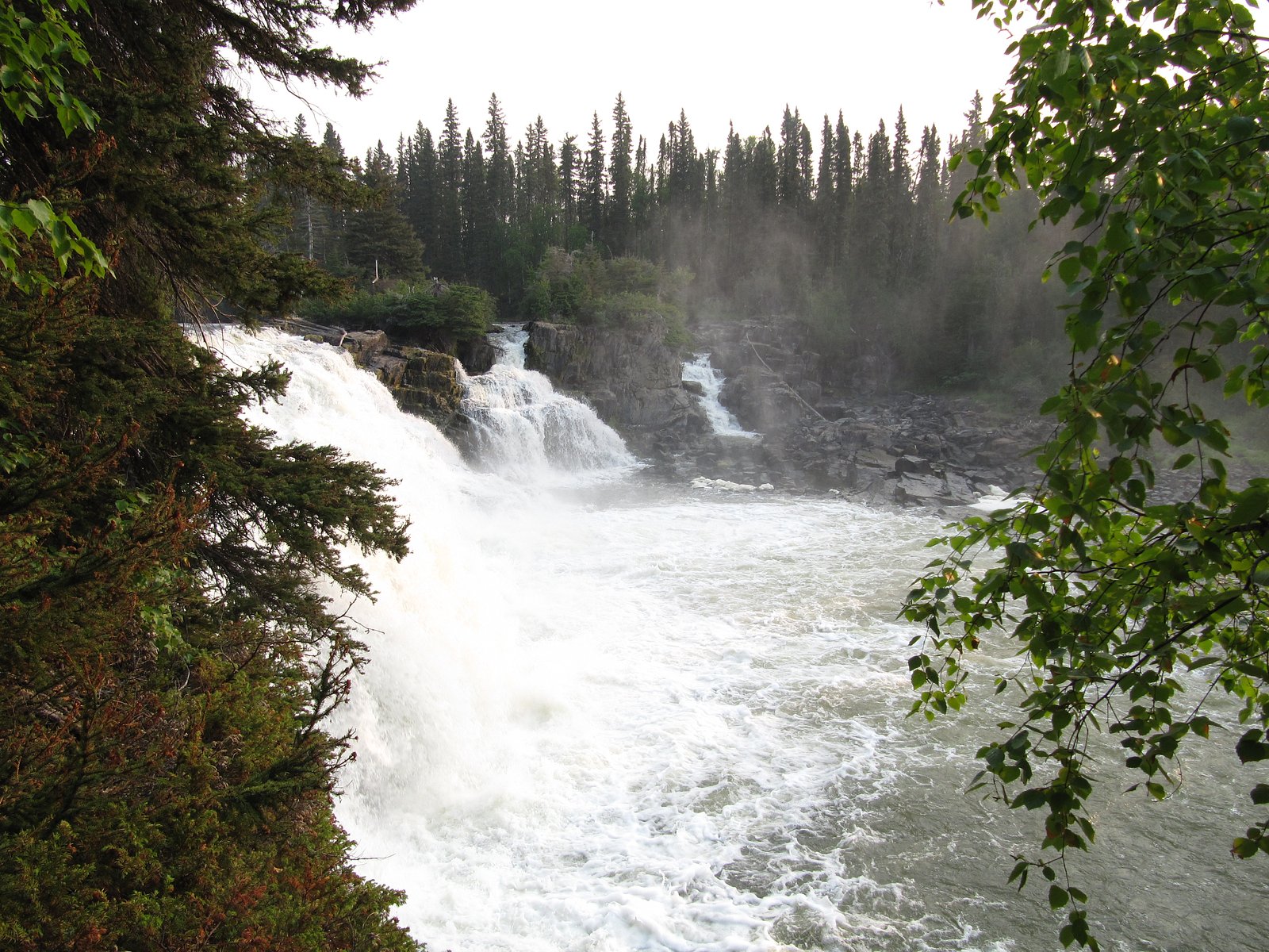
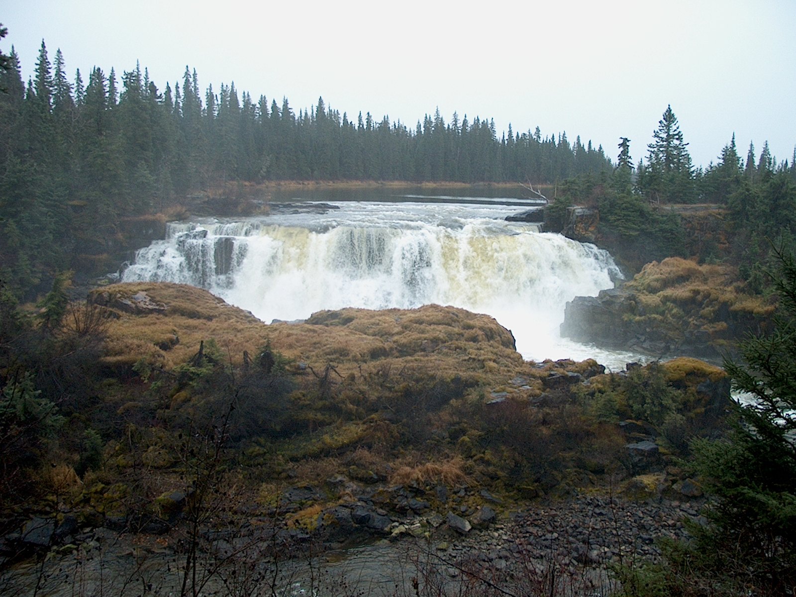
Kwasitchewan
Manitoba • 14 m
By Armen Suny · Last verified Jun 2026

Photo Credits (1)
Difficulty
Hard
Trail Length
26.6 km
Trail Type
Loop
Elevation Gain
790 m
About Kwasitchewan
Kwasitchewan Falls is a waterfall in northern Manitoba, Canada, and the highest waterfall in the province, at 14 metres (46 ft) high. It is located in Pisew Falls Provincial Park and is a 32-kilometre (20 mi) return hike from Pisew Falls, the namesake of the park and the second-highest waterfall in the province. The falls are located on the Grass River and were historically a part of the fur traders' route to the interior of Western Canada via the Saskatchewan River basin, guided by the indigenous peoples of the area.
The Setting
Kwasitchewan sits at 202 metres in the foothills of Manitoba. The falls drop 14 metres.
Why This Waterfall Exists
Kwasitchewan flows over hard intrusive rock, primarily tonalite, laid down over 2.5-4.0 billion years ago. These resistant rocks form a durable ledge that water cannot easily wear away, creating a 45-foot drop where softer material downstream has already eroded.
Trail & Hike Details
The Approach
The hard 26.6-km loop trail gains 790 metres of elevation on the way to the falls.
Trail Description
There is no widely published maintained trail to Kwasitchewan. Approaches reported for similar northern-Manitoba waterfalls typically involve water travel (canoe/boat), floatplane drop-offs, or cross-country bushwhacking from logging roads or water access points. Expect unmarked terrain, roots, muskeg, rocky shorelines and potentially steep, slippery banks immediately adjacent to the river or falls. Navigation should be by GPS and topo map; local waterways and portage routes may be required.
What to Expect
The falls drop 14 metres over hard intrusive rock.
Accessibility
The trail involves steep, uneven terrain with significant elevation change and is not accessible to mobility devices.
Frequently Asked Questions
🐶 Are Dogs Allowed at Kwasitchewan?
❌ Dogs are not allowed
Are There Any Fees or Permits Required?
🆖 No fees required
🏊 Is There Swimming at Kwasitchewan?
❌ Swimming is not allowed
When to Visit
Late spring (snowmelt and higher flows) and early summer often provide the most dramatic water flow. Summer is typically easiest for travel by small craft and milder weather. Fall can offer quieter conditions and autumn color but shorter daylight. Winter may render the falls partly frozen and accessible only by snowmobile or ski/snowshoe with appropriate winter skills; use caution with ice/river conditions.
Seasonal Access
The best time to visit is Spring, Summer, Fall, and Winter. Check with the managing park or local authority for current conditions.
Safety Information
Hazards include: swift currents and undertows near the falls, slippery and unstable rocks, cold water temperatures, lack of cell phone coverage, remote location with limited rescue resources, severe weather, and insects. Carry appropriate safety and navigation gear, and avoid approaching the edge of the falls. If approaching by water, use lifejackets and be skilled at river/canoe handling. Always err on the side of caution; if you cannot confirm route conditions, consider hiring local guides or outfitters.
Current Water Conditions
Based on a Water Survey of Canada gauge 25.7 km away
10.3 m³/s
Current discharge — how much water is flowing
Higher than usual for this time of year
Based on 52 years of record
28.44 m
Water depth at gauge
7-Day Discharge Trend
What does this mean for your visit?
The water is flowing higher than usual for this time of year.
About This Gauge
This gauge is on a regional waterway. Conditions at the falls may differ, especially after local rain.
7-Day Flow Outlook
Based on the WSC gauge TAYLOR RIVER NEAR THOMPSON (26 km away).
Today
Roaring
12 m³/s
6/10Tomorrow
Roaring
12 m³/s
6/10Tue
Strong
11 m³/s
8/10Wed
Strong
11 m³/s
8/10Thu
Strong
9.7 m³/s
10/10Fri
Strong
9.5 m³/s
8/10Sat
Strong
9.2 m³/s
8/10Best window: Thu — strong flow, mainly sunny (trip score 10/10).
Best time of year: this gauge typically runs highest from early May to late July, peaking in May.
How we calculate this
This is a transparent outlook, not a precise forecast. We take the waterfall's current flow strength (how it ranks against its historical normal for today, from the nearest WSC stream gauge), carry that ranking forward along the gauge's seasonal curve, and nudge it for forecast rain. Confidence is highest for the next day or two and falls further out. Always check official conditions and your own judgment before visiting — high flows can be dangerous.
Know when to go.
Get a free email alert when waterfalls near Thompson hit peak flow. We only send when conditions are worth the trip — no weekly newsletters, no spam.
Weather Forecast
Location & Access
Getting There
Kwasitchewan is in a remote northern Manitoba location (55.2654, -98.2898). There is no well-documented public trailhead listed in major trail resources. Typical access for features in this region is via floatplane, canoe/boat along connected rivers/lakes, remote bush roads or multi-day backcountry hikes. The nearest population centers are Thompson (~41.6 miles / ~67 km) and Nelson House (~49.8 miles / ~80 km). Visitors should plan a multi-modal approach and confirm access options with local outfitters or Manitoba provincial authorities before travel.
Get Directions on Google MapsParking
No formal parking or developed trailhead is known at the waterfall itself. If approaching by road to a put-in or staging area, parking will be informal and subject to local conditions; use official lots in Thompson or at an established boat launch if starting by water. Expect no maintained parking at the immediate site.
Elevation
202 metres above sea level
Coordinates
55.265405° N, -98.289841° W
Visitor Tips & Gear
• Confirm access options with local outfitters, Manitoba Parks/Forestry, or Indigenous community offices before travel. • Carry a topographic map, GPS, and reliable compass; plan for limited to no signage. • Practice Leave No Trace: pack out all waste. • Wear sturdy, waterproof footwear; rocks near the falls will be slippery. • Bring insect protection (spring/summer) and layers for rapidly changing weather. • Inform someone of your route and expected return; consider satellite messaging in areas without cell service. • Respect private land and Indigenous territories, check access permissions.
As an Amazon Associate, we earn from qualifying purchases.
This challenging 26.6 km trail gains 790 m in elevation — come prepared with proper hiking boots and trekking poles. Icy conditions are common in winter — traction cleats are a smart addition.

Columbia Watertight II Rain Jacket
Packs into its own pocket, seam-sealed, and keeps you dry from spray and surprise rain.

Sawyer Squeeze Water Filter
The backcountry standard — filters 99.9% of bacteria and weighs just 3 oz.

Polarized Sunglasses (Knockaround)
Cuts glare off the water so you actually see the falls — and your photos turn out better too.

Earth Pak Waterproof Dry Bag
Keeps your phone and gear dry when waterfall mist soaks everything else.

Waterproof Phone Pouch (AiRunTech)
Cheap insurance — take photos right next to the falls without killing your phone.

Timberland Euro Sprint Mid Waterproof
Trusted waterproof boot with premium leather and grippy rubber sole — reliable on rocky, wet trails.
Where to Stay
Browse vacation cabins and private rentals nearby
Unique outdoor stays — tents, yurts, and treehouses
Rent a campervan or RV for your waterfall road trip
Some links are affiliate links. We may earn a commission at no extra cost to you.
Nearby Campground
Lakeview
27.6 km away
Additional Information
Nearby Attractions
Nearest communities: Thompson (~41.6 miles) and Nelson House (~49.8 miles). The wider region contains numerous lakes, rivers and remote backcountry canoe routes common to northern Manitoba; specific nearby parks or named attractions are not well-documented for this exact coordinate, confirm with Manitoba tourism or local outfitters.
Wildlife
Typical boreal wildlife may include moose, black bear, wolves, beavers, foxes and a variety of waterfowl and songbirds. Insect activity (mosquitoes, black flies) can be intense in spring and summer. Practice normal wildlife safety precautions.
Cities near Kwasitchewan
Nearby Waterfalls
Writing about Kwasitchewan? Embed this waterfall on your site for free.