
Keyhole Falls
British Columbia • 37 m
By Armen Suny · Last verified Jun 2026
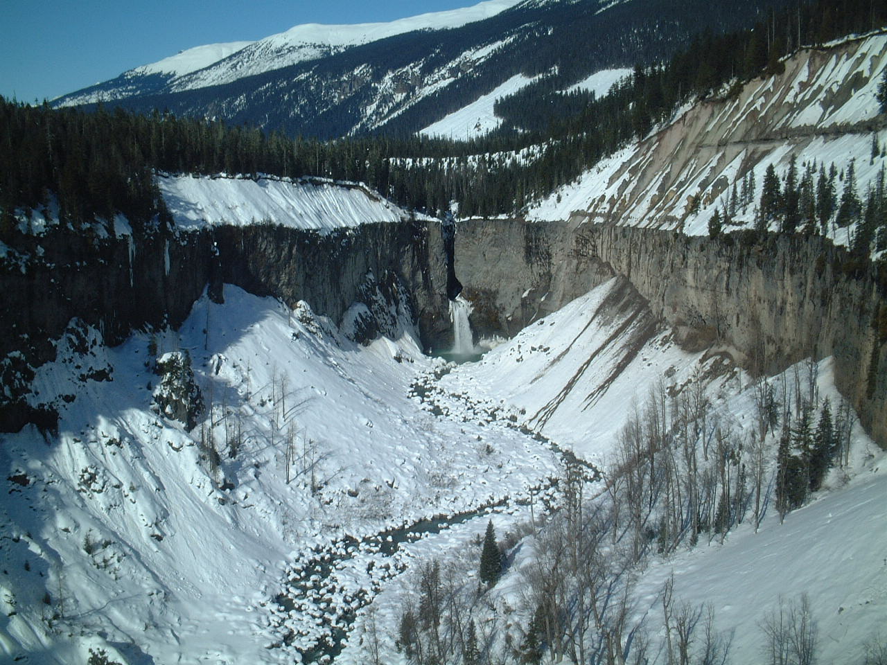
Photo Credits (1)
Difficulty
Easy
Trail Length
3.5 km
Trail Type
Out And Back
Elevation Gain
167 m
About Keyhole Falls
Keyhole Falls is the unofficial name for the largest waterfall along the Lillooet River in British Columbia, Canada. The falls are 115 feet (35 m) high and are a punchbowl type of waterfall.
The Setting
Keyhole Falls sits at 683 metres in the hills of British Columbia. At 37 metres, it is among the taller waterfalls in British Columbia.
Why This Waterfall Exists
Keyhole Falls flows over Garibaldi Group, a hard volcanic rock layer deposited about 5 million years ago. These resistant rocks form a durable ledge that water cannot easily wear away, creating a 121-foot drop where softer material downstream has already eroded.
Trail & Hike Details
The Approach
The easy 3.5-km out-and-back trail gains 167 metres of elevation on the way to the falls.
Trail Description
There is no well-documented maintained trail for Keyhole Falls in widely available official sources. Visitors should anticipate limited or informal trails, potential route-finding through forest, and sections of unstable or muddy ground. If a short access path exists it may be steep, unmarked, or cross riparian terrain. Use topographic maps, GPS coordinates, and recent trip reports to plan the route.
What to Expect
The falls cascade 37 metres over hard volcanic rock.
Accessibility
The trail is not wheelchair accessible. Uneven terrain and elevation changes require steady footing.
Frequently Asked Questions
🐶 Are Dogs Allowed at Keyhole Falls?
❌ Dogs are not allowed
Are There Any Fees or Permits Required?
🆖 No fees required
🏊 Is There Swimming at Keyhole Falls?
❌ Swimming is not allowed
When to Visit
Late spring to early summer for higher flows and more dramatic water volume. Summer offers easier road and trail access in most years. Fall can provide good color and cooler temperatures but flows may be reduced. Winter conditions can make access difficult or hazardous due to snow, ice, and avalanche risk; consider this when planning.
Seasonal Access
The best time to visit is Spring, Summer, and Fall. Winter access may be limited. Check with the managing park or local authority for current conditions.
Safety Information
Hazards may include slippery rocks and roots, steep drop-offs near the stream, fast or cold water, changing flow conditions after rain or snowmelt, poor or no cell coverage, unmaintained roads, and wildlife encounters. In winter, there may be snow, ice, and avalanche risk. Always use caution near water; avoid climbing on wet ledges or getting too close to the lip of the falls. Check local advisories and recent trip reports for current conditions.
Current Water Conditions
40.8 m³/s
Current discharge — how much water is flowing
About average for this time of year
Based on 47 years of record
1.49 m
Water depth at gauge
7-Day Discharge Trend
What does this mean for your visit?
Flow is about average for this time of year.
About This Gauge
This gauge is on a nearby waterway and may not reflect exact conditions at the falls.
7-Day Flow Outlook
Based on the WSC gauge BRIDGE RIVER (SOUTH BRANCH) BELOW BRIDGE GLACIER (20 km away).
Today
Moderate
41 m³/s
6/10Tomorrow
Moderate
43 m³/s
8/10Thu
Moderate
44 m³/s
5/10Fri
Moderate
45 m³/s
6/10Sat
Moderate
44 m³/s
6/10Sun
Moderate
47 m³/s
6/10Mon
Moderate
44 m³/s
6/10Best window: Tomorrow — moderate flow, mainly sunny (trip score 8/10).
Best time of year: this gauge typically runs highest from mid June to mid September, peaking in August.
How we calculate this
This is a transparent outlook, not a precise forecast. We take the waterfall's current flow strength (how it ranks against its historical normal for today, from the nearest WSC stream gauge), carry that ranking forward along the gauge's seasonal curve, and nudge it for forecast rain. Confidence is highest for the next day or two and falls further out. Always check official conditions and your own judgment before visiting — high flows can be dangerous.
Weather Forecast
Location & Access
Getting There
The falls are at the given coordinates (50.6766, -123.4728). Access is likely via forest service or logging roads off the nearest numbered highway and then by foot. Expect unpaved roads and possible need for high-clearance or 4WD; check recent trip reports and local forestry or park resources before travel. Cell coverage may be limited; carry a map, GPS, or offline mapping.
Get Directions on Google MapsParking
No confirmed developed parking lot is documented. Parking may be roadside at a trailhead or along a forest service road; use caution and avoid blocking gates or private driveways.
Elevation
683 metres above sea level
Coordinates
50.676605° N, -123.472820° W
Visitor Tips & Gear
• Check recent trip reports or local hiking forums for up-to-date access and road conditions before you go. • Use a map and GPS; don't rely solely on cell service. • Wear sturdy waterproof hiking boots and bring trekking poles if you plan to navigate steep or slippery sections. • Practice Leave No Trace: pack out trash and avoid disturbing vegetation and stream banks. • Let someone know your plans and expected return time.
As an Amazon Associate, we earn from qualifying purchases.
This easy 3.5 km hike is straightforward — comfortable trail shoes and plenty of water should do. Sun exposure on the trail makes good sun protection a must in summer.

Polarized Sunglasses (Knockaround)
Cuts glare off the water so you actually see the falls — and your photos turn out better too.

Columbia Watertight II Rain Jacket
Packs into its own pocket, seam-sealed, and keeps you dry from spray and surprise rain.

Earth Pak Waterproof Dry Bag
Keeps your phone and gear dry when waterfall mist soaks everything else.

Waterproof Phone Pouch (AiRunTech)
Cheap insurance — take photos right next to the falls without killing your phone.

JOBY GorillaPod Starter Kit
Wraps around railings and rocks for long-exposure waterfall shots — no flat surface needed.

Osprey Daylite Daypack
Light, organized, and just the right size for a day hike — fits water, snacks, and layers.
Where to Stay
Browse vacation cabins and private rentals nearby
Unique outdoor stays — tents, yurts, and treehouses
Rent a campervan or RV for your waterfall road trip
Some links are affiliate links. We may earn a commission at no extra cost to you.
Nearby Campground
Keyhole Hot Springs Camp Site
1.6 km away
Additional Information
Nearby Attractions
The falls are in the Coast Mountains region of southwestern British Columbia. Depending on your route, nearby points of interest may include provincial parks, alpine hiking areas, rivers, and backcountry recreational areas typical of the region. Check local maps for named parks and trails near the coordinates.
Wildlife
Typical coastal-mountain wildlife may be present: black bears, deer, small mammals, and birds. Mosquitoes and other biting insects can be abundant in spring and summer. Use standard wildlife-safety precautions (store food securely, carry bear spray where appropriate).
Writing about Keyhole Falls? Embed this waterfall on your site for free.