Photo Credits (2)
About Jesse Falls
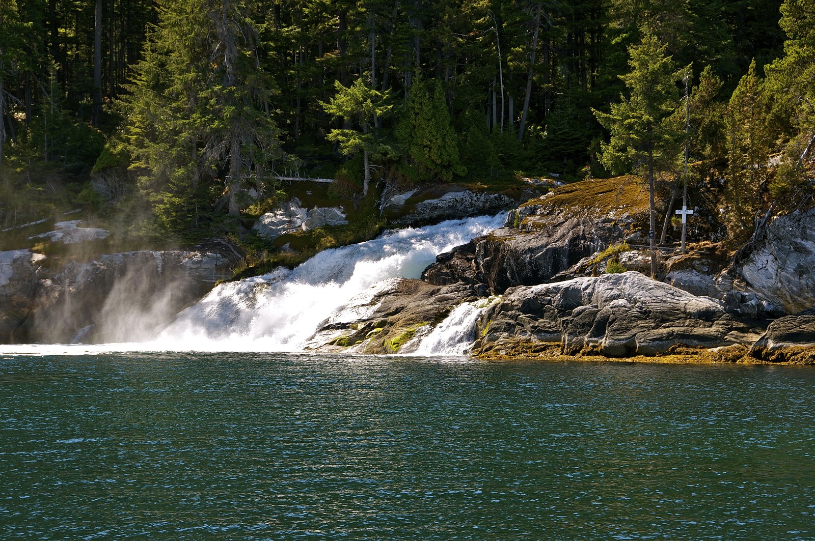
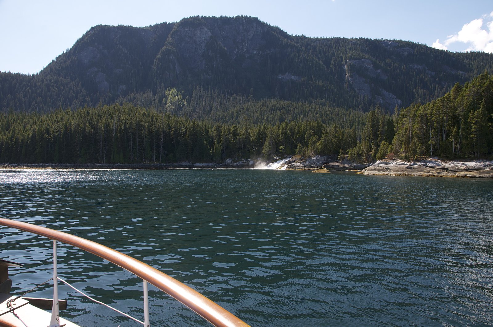
Jesse Falls is a relatively remote waterfall in northwestern British Columbia, located roughly 44.5 miles (user-provided) from Terrace. Coordinates supplied: 53.8355, -128.8673. The site appears to be in a forested, coastal-mountain environment typical of the Terrace region, with likely cascades and plunge sections. Visitor information for an established, maintained trail is limited; access may require travel on logging or resource roads and an unmaintained approach trail. Flow is likely highest in spring snowmelt and after heavy rains. Details below are conservative where information is uncertain.
Why This Waterfall Exists
Jesse Falls flows over hard intrusive rock laid down about 23-66 million years ago. These resistant rocks form a durable ledge that water cannot easily wear away, creating the falls where softer material downstream has already eroded.
Trail & Hike Details
Trail Description
There is no widely documented, maintained trail to Jesse Falls in major trail guides. The approach is likely via a combination of logging/resource roads and an unmaintained footpath or cross-country bushwhack. Expect uneven, muddy or rocky terrain, stream crossings, and dense understory in places. Trail markers and infrastructure (stairs, railings, viewing platforms) may be absent. Hikers should be prepared for route-finding and possibly scrambling near the falls.
What to Expect
Forest-dominated scenery (coastal temperate rainforest / mountain forest), rocky stream channel and cascades, variable water flow (peak in spring and after heavy rain). Limited or no visitor facilities (no restrooms, signage, or maintained overlooks expected). Slippery rocks, fallen trees, and brush on the approach; possible log-transport activity or gated roads if the area is used for forestry.
Accessibility
Likely not wheelchair or stroller accessible. Expect uneven, steep, muddy and/or rocky terrain with no formal infrastructure. Accessibility for people with limited mobility is likely poor.
Frequently Asked Questions
🐶 Are Dogs Allowed at Jesse Falls?
❌ Dogs are not allowed
Are There Any Fees or Permits Required?
🆖 No fees required
🏊 Is There Swimming at Jesse Falls?
❌ Swimming is not allowed
When to Visit
Late spring to early summer for highest flows and safer access on seasonal roads; late summer for more stable road conditions but lower flow. Fall can offer good color but increasing rain and early snow may make access difficult. Winter access may be limited or hazardous (snow, ice, closed roads).
Seasonal Access
The best time to visit is Spring, Summer, Fall, and Winter. Check with the managing park or local authority for current conditions.
Safety Information
This is a remote and likely unmaintained site. Hazards include rough logging roads, limited or no cell service, slippery rocks, steep and unstable banks or cliffs, cold and fast-moving water, potential for wildlife encounters (bears), and changing weather. Travel with a partner when possible, tell someone your route and expected return time, carry a fully charged phone and emergency communications device if available, and check local road and weather conditions before departing. If road gates are locked, do not trespass, contact local authorities for access information.
Current Water Conditions
0.0 m³/s
Current discharge — how much water is flowing
Lower than usual for this time of year
Based on 27 years of record
2.25 m
Water depth at gauge
7-Day Discharge Trend
What does this mean for your visit?
Flow is lower than usual for this time of year.
About This Gauge
This gauge is on a nearby waterway and may not reflect exact conditions at the falls.
7-Day Flow Outlook
Based on the WSC gauge RENEGADE CREEK NEAR KITIMAT (15 km away).
Today
Low
0.0 m³/s
4/10Tomorrow
Low
0.0 m³/s
6/10Tue
Low
0.0 m³/s
6/10Wed
Low
0.0 m³/s
6/10Thu
Low
0.0 m³/s
6/10Fri
Low
0.0 m³/s
5/10Sat
Low
0.0 m³/s
4/10Best window: Tomorrow — low flow, mainly sunny (trip score 6/10).
Best time of year: this gauge typically runs highest from early April to mid May, peaking in May.
How we calculate this
This is a transparent outlook, not a precise forecast. We take the waterfall's current flow strength (how it ranks against its historical normal for today, from the nearest WSC stream gauge), carry that ranking forward along the gauge's seasonal curve, and nudge it for forecast rain. Confidence is highest for the next day or two and falls further out. Always check official conditions and your own judgment before visiting — high flows can be dangerous.
Know when to go.
Get a free email alert when waterfalls near Terrace hit peak flow. We only send when conditions are worth the trip — no weekly newsletters, no spam.
Weather Forecast
Location & Access
Getting There
Approximate coordinates: 53.8355, -128.8673. From Terrace (BC) travel roughly 44–45 miles by vehicle toward the general area indicated (user-provided distance). Access may require leaving Highway 16 and driving on secondary or logging roads; these roads can be rough and may require a high-clearance or 4x4 vehicle. The final approach may involve an unmarked spur road and a short cross-country or lightly-used footpath. Cell service may be intermittent, carry downloaded maps/GPS and inform someone of your plans.
Get Directions on Google MapsParking
No confirmed formal parking lot. Expect a roadside pullout or informal parking at the end of a logging spur. Park clear of gates and respect posted private property and resource-road signage. If uncertain, return to the nearest town (Terrace) or forestry office for current road/parking guidance.
Elevation
13 metres above sea level
Coordinates
53.835490° N, -128.867271° W
Visitor Tips & Gear
1) Confirm current road and access conditions with local authorities (Terrace visitor centre or regional forestry office) before heading out. 2) Use a high-clearance vehicle for logging roads; avoid low-clearance cars. 3) Bring a GPS with the provided coordinates and a paper map; download offline maps. 4) Wear sturdy, waterproof footwear and expect muddy/slick conditions. 5) Respect private and industrial roads, do not block gates. 6) Practice Leave No Trace; pack out what you bring. 7) Be bear-aware: carry bear spray and know how to use it. 8) Avoid cliff edges and wet rock near the falls.
Where to Stay
Browse vacation cabins and private rentals nearby
Unique outdoor stays — tents, yurts, and treehouses
Rent a campervan or RV for your waterfall road trip
Some links are affiliate links. We may earn a commission at no extra cost to you.
Nearby Campground
Radley Park
27.4 km away
Additional Information
Nearby Attractions
Nearest service town: Terrace, BC. Within driving distance from Terrace are attractions such as Kitselas Canyon (railway canyon & canyon viewpoints), Kleanza Creek Provincial Park (known for salmon and forest trails), the Skeena River corridor, and regional access to other waterfalls and salmon-bearing streams. Confirm distances and road conditions locally.
Wildlife
Typical northwestern BC wildlife: black bears, possibly grizzly in broader region, black-tailed deer/moose in some areas, cougars (rare), small mammals, and a variety of birds. Salmon runs in regional rivers and creeks may attract bears, exercise extra caution during salmon season.
Cities near Jesse Falls
Writing about Jesse Falls? Embed this waterfall on your site for free.